Issue Date: Sunday, September 4th, 2016
Issue Time: 9:10AM MDT
— Flooding is NOT expected today
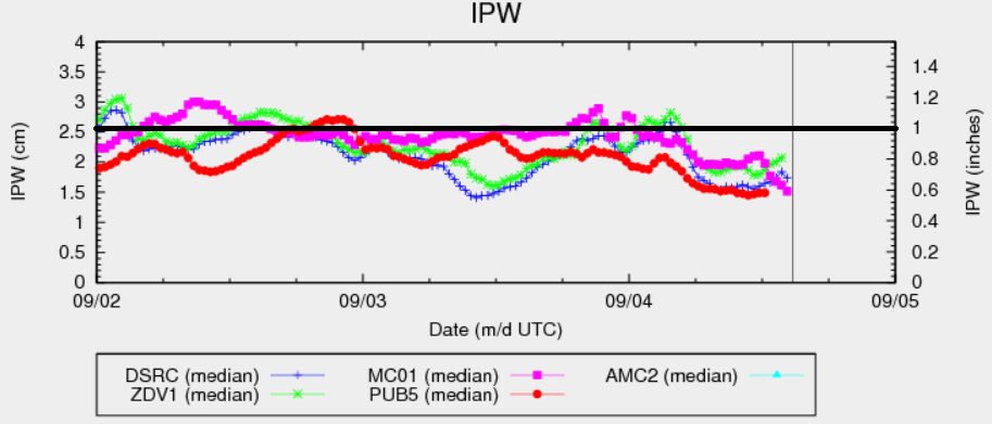
After a prolonged period of widespread active weather, today will see a transitioning to overall quieter conditions. The large-scale disturbance that has been in our discussions for nearly a week now is still positioned west of Colorado. However, the main difference is that with strong southwesterly flow aloft, moisture has decreased significantly over most of Colorado today. The precipitable water chart, below, shows a unanimous decline at the five sites shown here (Denver, Boulder, Pueblo, Grand Junction and Colorado Springs) into the 0.6 to 0.8 inch range. The one exception to this conclusion is in the far northeast part of the state. There, a small pocket of moister air and instability will remain this afternoon. This is expected to cause scattered thunderstorms, capable of large hail up to 1.5 inches and a tornado or two. However, with steering winds of 40mph+, these storms could produce short-term heavy rainfall, but will simply not have enough time to cause a flooding threat.
Today’s Flood Threat Map
For more information on today’s flood threat, see the map below (hover over threat areas for more details). For Zone-Specific forecasts, scroll below the map.

Zone-Specific Forecasts:
Northeast Plains:
Isolated to scattered thunderstorms developing in the far northeast by early afternoon. Max 1-hr rain rates up to 1.0 inch. Flooding is not expected today but hail up to 1.5 inches, gusty winds and an isolated tornado are possible.
Primetime: 2PM to 7PM
Front Range, Urban Corridor, Southeast Mountains, Raton Ridge, Southeast Plains, Palmer Ridge:
Sunny early, then partly cloudy with scattered showers and a weak storm possible in the afternoon. Max 1-hr rainfall up to 0.5 inches possible. Hail up to 0.5 inches and winds up to 50 mph are possible with the strongest storms. Flooding is not expected today.
Primetime: 1PM to 7PM
San Juan Mountains, Southwest Slope, Grand Valley, Central Mountains, San Luis Valley, Northwest Slope, Northern Mountains:
Partly cloudy with scattered showers and weak thunderstorms increasing in coverage through the day. Max 1-hr rainfall up to 0.5 inches with max 24-hour totals up to 0.8 inches possible over the higher terrain of the Northern and Central Mountains. Snow level will be as low as 12,000 feet in northern areas. Hail up to 0.5 inches will be possible with the strongest storm near the Wyoming border.
Primetime: 11AM to 7PM