FTB 05-03-2017: Gradual Clearing Expected as Disturbance Moves Away

Issue Date: 5/3/2017
Issue Time: 9:30 AM MDT

— Flooding is NOT expected today.

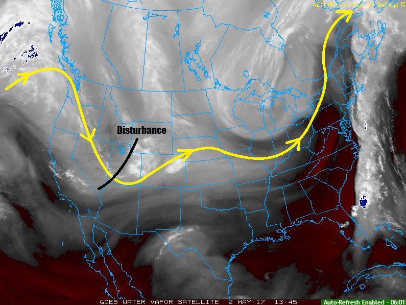
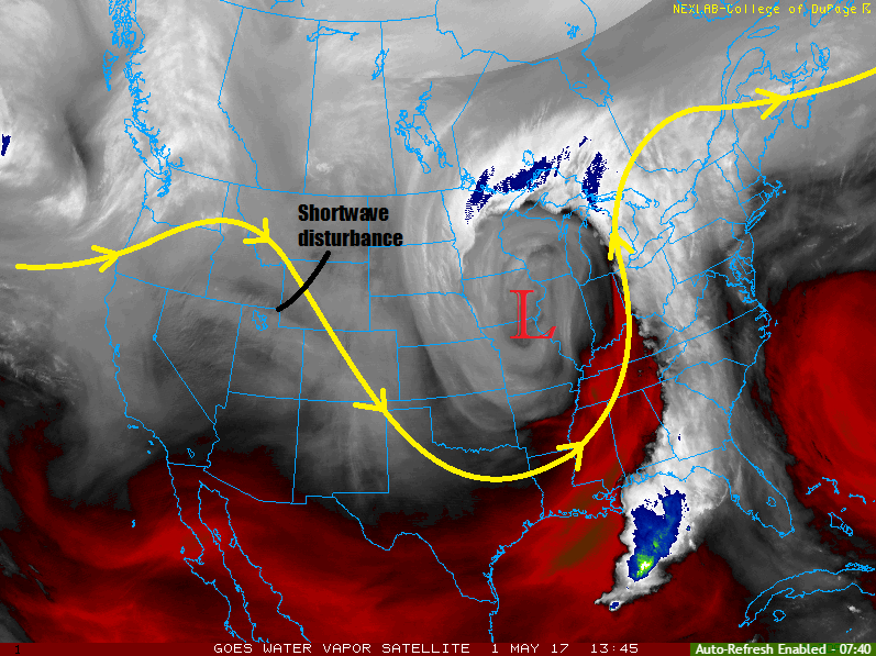
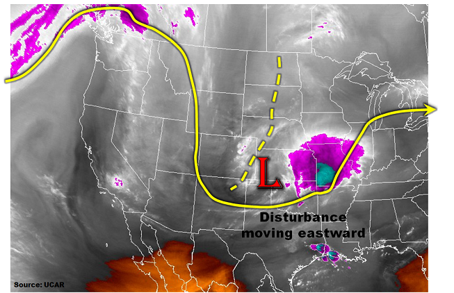
This morning’s water vapor imagery shows a large-scale trough draped across the northern Great Plains, stretching south-southwest into eastern Colorado. This vigorous disturbance is generating cloud cover and light to moderate rain showers east of the Continental Divide. As the disturbance moves eastward today, a ridge axis will replace its place over Colorado. This means gradually clearing skies for areas east of the Continental Divide (joining the already sunny western areas). Nonetheless, up to 0.4 inches of beneficial rainfall will occur from the late morning to early evening hours across parts of eastern Colorado. Flooding is not expected today across the state.

Today’s Flood Threat Map

For more information on today’s flood threat, see the map below (hover over threat areas for more details). For Zone-Specific forecasts, jump below the map.

Flood Threat Legend

Zone-Specific Forecasts:

Southeast Plains, Northeast Plains, Palmer Ridge, Raton Ridge, Front Range, Urban Corridor, Southeast Mountains, Central Mountains, Northern Mountains:

Overcast skies this morning continuing into the late afternoon, with some gradual clearing especially for western areas. Light to moderate rainfall (snow level 6,500 feet this morning lifting to 9,000 feet by afternoon) will continue mainly across the Urban Corridor, Northeast and Southeast Plains and the Palmer Ridge. A weak thunderstorm, capable of producing hail up to 0.5 inches cannot be ruled out. One-hour rainfall rates up to 0.4 inches will be possible under the heaviest showers. Total daily rainfall up to 0.5 inches will be possible. Flooding is not expected today.

Primetime: 11AM to 6PM

San Juan Mountains, Southwest Slope, Grand Valley, San Luis Valley, Northwest Slope:

Partly to mostly sunny skies with temperatures slightly below seasonal normal.


FTB 05-02-2017: Unsettled Weather Expected as Disturbance Swings Through

Issue Date: 5/2/2017
Issue Time: 9:30 AM

NO FLOOD THREAT IS FORECAST.

As noted on the water vapor image below, and upper-level disturbance will rotate across the region today, resulting in unsettled weather through the period. Most of the precipitation will be in the form of rain and snow (above ~9000 feet) showers. There will be a *bit* of instability available, so a few garden-variety thunderstorms are possible. The threat from thunderstorms will mainly be gusty winds and brief periods of moderate rainfall. Moisture is still lacking in terms of a flood threat, so no flood threat will be issued. Later this evening and overnight, snow levels will fall to around 7,000-8,000 feet.

Generally speaking, rainfall totals will range from a trace to 0.5 inches (with pockets of rainfall up to 0.7 inches). Snow totals will generally range from 1-3 inches, with pockets of snowfall up to 6 inches across the higher peaks of the Northern and Central Mountains regions. For more information, please check the zone-specific forecast discussions below.

Today’s Flood Threat Map

For more information on today’s flood threat, see the map below (hover over threat areas for more details). For Zone-Specific forecasts, jump below the map.

Flood Threat Legend

Zone-Specific Forecasts

Urban Corridor, Palmer Ridge, Northeast Plains, Southeast Plains, and Raton Ridge:

Scattered-to-widespread showers, and a couple thunderstorms, are expected today/tonight, with lingering showers expected into the morning hours tomorrow. Rain rates will generally be light (0.1-0.25 inches/hour), with a few heavier rain rates (0.4-0.7 inches/hour) underneath thunderstorms. The main threats from thunderstorms will be gusty winds, brief periods of moderate rainfall, and pea-sized hail. The far Southeast Plains have the best opportunity for a stronger thunderstorm, with hail up to 0.75” in diameter.

Timing: Noon – Midnight, with lingering showers into the early morning hours

Northern Mountains, Northwest Slope, Front Range, Southeast Mountains, San Juan Mountains, Southwest Slope, Central Mountains, Grand Valley, and San Luis Valley:

Scattered rain and snow showers are expected today/tonight, with most precipitation ending around 10-11 PM. A few lingering showers will hang around the Front Range and Southeast Mountains into the early morning hours. A couple garden-variety thunderstorms cannot be ruled out, thanks to the presence of marginal instability. Any thunderstorms will bring a threat of gusty winds and pea-sized hail, with rain rates 0.2-0.4 inches/hour. Most rainfall will occur at rates of 0.05-0.15 inches/hour.

The best coverage of precipitation will occur in the Front Range, Southeast Mountains, Northern Mountains, Central Mountains, and Northwest Slope regions, with the least amount of coverage across the Southwest Slope.

FTB 05-01-2017: Rain/Snow Showers Expected

Issue Date: 5/1/2017
Issue Time: 9:30 AM

NO FLOOD THREAT IS FORECAST.

Welcome back to the Colorado Flood Threat Bulletin for the 2017 season.

A shortwave disturbance (noted in water vapor image below) embedded in northwesterly flow aloft will trigger isolated-to-scattered rain/snow showers across Colorado through this evening. Generally speaking, most of the activity will occur north of I-70, thanks to better environmental support from the passing disturbance. Moisture values are seasonably low, so precipitation will remain well below any flood threat thresholds. Shower activity will end during the late evening hours with dry conditions expected overnight for the state.

Today’s Flood Threat Map

For more information on today’s flood threat, see the map below (hover over threat areas for more details). For Zone-Specific forecasts, jump below the map.

Flood Threat Legend

Zone-Specific Forecasts

Urban Corridor, Palmer Ridge, Northeast Plains, and Southeast Plains:

Mostly sunny skies this morning will give way to increasing clouds through the afternoon and evening hours as the disturbance moves overhead. Most showers will remain light, with maximum rain rates around 0.1-0.3 inches/hour. Most of the shower activity will occur north of I-70, and near the mountains/Cheyenne Ridge. Shower activity will come to an end between 6-8 PM, with dry conditions expected overnight.

Northern Mountains, Northwest Slope, Front Range, Southeast Mountains, San Juan Mountains, Southwest Slope, Central Mountains, Grand Valley, Raton Ridge, and San Luis Valley:

Orographic lift will combine with the disturbance aloft to produce isolated-to-widely scattered showers through the early evening, mainly for the Northern Mountains, Northwest Slope, Central Mountains, and Front Range regions. Elsewhere, shower activity cannot be ruled out, but will be less in both number and intensity. Expect precipitation to fall as snow above 10,500 feet, with rain below. Maximum rain rates will be 0.1-0.25 inches/hour, and snow accumulations will be light (Trace-3 inches).

Showers will come to an end during the early evening hours, with dry conditions expected overnight.

FTB 09-30-2016: Moisture Spreading Eastward

Issue Date: 9/30/2016
Issue Time: 10:03 AM

NO FLOOD THREAT IS FORECAST.

REMINDER: THIS IS THE FINAL FTB OF THE 2016 SEASON. IT HAS BEEN A PLEASURE TO SERVE YOU. THE NEXT FTB SEASON BEGINS ON MAY 1, 2017.

The moisture plume that has been laying across western Colorado for a couple of days now is on the move eastward, evidenced in the IPW chart below. Grand Junction IPW (green line) remains elevated, at around 1 inch, while Boulder (blue line) and Schriever AFB (pink line) are on a steady march upward. All in all, there will be plenty of moisture to fuel another period of scattered showers/isolated thunderstorms across much of the High Country and Western Slope, with lesser amounts of activity spilling over the Urban Corridor, and western extents of the Southeast Plains, Palmer Ridge, and Raton Ridge. Generally speaking, areas east of a north-south line from Sterling-to-Flagler-to-Las Animas-to-Andrix will remain dry.

ipw_20160930

Most activity will be in the form of showers, with light-to-moderate rainfall being the main impact. A couple isolated thunderstorms will mix in, producing periods of moderate rainfall, perhaps brief bouts with localized heavy rainfall. Area burn scars such as Waldo Canyon and Hayden Pass should be monitored, but no flood threat is warranted due to dry antecedent conditions. Additionally, localized street ponding may be an issue on roadways, so be on the lookout for that, as well. For more information, including rain rates and timing, please see the zone-specific discussions below.

Today’s Flood Threat Map

For more information on today’s flood threat, see the map below (hover over threat areas for more details). For Zone-Specific forecasts, jump below the map.

Flood Threat Legend

Zone-Specific Forecasts

Urban Corridor, Palmer Ridge, Northeast Plains, Raton Ridge and Southeast Plains:

Scattered showers and a couple embedded thunderstorms are expected, with the most activity focused along and east of I-25. Isolated showers/thunderstorms will spread a bit further eastward, west of a north-south line from Sterling-to-Flagler-to-Las Animas-to-Andrix. East of this line, conditions are expected to remain dry, with more clouds than during previous days. Most rain rates will be light underneath showers, with efficient rainfall coming from more organized activity. Maximum rain rates are as follows:

Urban Corridor and Palmer Ridge: 0.6-0.8 inches/hour
Southeast Plains and Northeast Plains: 0.4-0.7 inches/hour
Raton Ridge: 0.3-0.6 inches/hour

Timing: 11 AM – 11 PM

Front Range, Southeast Mountains, San Luis Valley, Northern Mountains, Northwest Slope, San Juan Mountains, Southwest Slope, Central Mountains, and Grand Valley:

Scattered-to-numerous showers, and a few thunderstorms are expected, producing mainly light-to-moderate rainfall and gusty winds. One or two stronger thunderstorms will produce localized heavy rain, resulting in ponding on roadways and in low-lying areas. No flood threat is warranted as storm motions should keep activity moving at a decent clip, minimizing the threat from heavy rain. Maximum rain rates are as follows:

Southwest Slope and Grand Valley: 0.6-0.8 inches/hour
San Juan Mountains, Central Mountains, Northwest Slope, Northern Mountains, and Southeast Mountains: 0.4-0.7 inches/hour
Front Range: 0.5-0.9 inches/hour
San Luis Valley: 0.3-0.5 inches/hour

Timing: 11 AM – 9 PM for areas west of the Continental Divide, 11 AM – 1 AM for areas along and east of the Continental Divide