FTB 06-20-2017: Heat For Most, But A Few Storms Possible Far Southeast

Issue Date: Tuesday, June 20th
Issue Time: 11AM MDT

— Flooding is NOT expected today

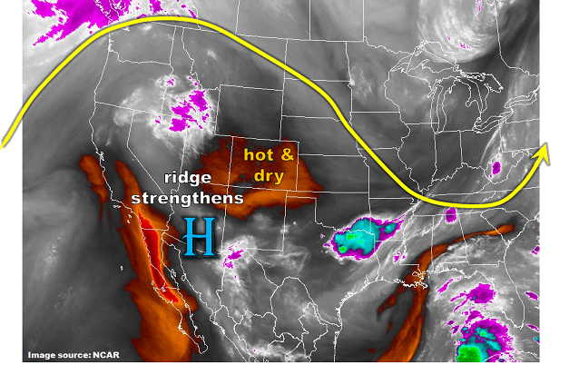
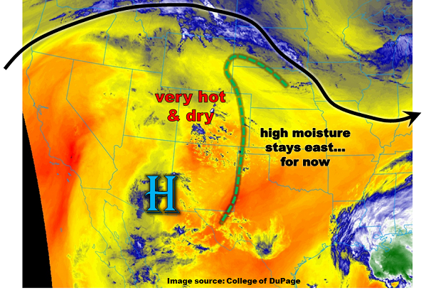
A high pressure ridge will continue to rule Colorado’s landscape on Tuesday. Temperatures will climb another 5 – 10F higher compared to Monday’s already warm afternoon, with highs exceeding 100F for most locations below 4,500 feet. Certainly a fitting story given that the summer solstice is at 10:24PM MDT tonight! Meanwhile, upslope flow will try to advect much higher moisture into Colorado from the east. A strong Precipitable Water (PW) gradient is noted this morning with Denver and Grand Junction tallying PW below 0.5 inch while locations just east of the Kansas border are above 1 inch. With the higher moisture content, an axis of moderate to strong instability will develop in far southeast Colorado today. Isolated heavy rainfall will be possible with these storms, but we expect that any storm capable of flood-intensity rainfall will move into KS, OK and NM before that can occur. Thus, no flooding is expected today. These cells will also be capable of producing large hail up to 1.75 inches and gusty winds.

Elsewhere, the Arkansas and Roaring Fork rivers continue to run slightly above “Action” levels this morning. With snow melt already peaking and no additional precipitation, these rivers should peak in the very short term and no flooding is expected.

Today’s Flood Threat Map

For more information on today’s flood threat, see the map below (hover over threat areas for more details). For Zone-Specific forecasts, scroll below the map.

Zone-Specific Forecasts:

Southeast Plains:

Partly cloudy and hot with an isolated shower or thunderstorm possible along the NM, OK and KS borders. Max 1-hour rainfall up to 1.4 inches. Large hail and gusty winds could accompany the strongest cells. Flooding is not expected today.

Primetime: 2PM to 9PM

Northeast Plains, Urban Corridor, Front Range, Palmer Ridge, Raton Ridge, Southeast Mountains, San Luis Valley:

Mostly sunny and continued warmer today with temperatures exceeding 100F below 5,000 feet. Flooding is not expected today.

Grand Valley, Northwest Slope, Northern Mountains, Central Mountains, Southwest Slope, San Juan Mountains:

Mostly sunny and very hot today with high temperatures exceeding 100F for most locations below 4,500 feet. A Heat Advisory is in effect for parts of the Colorado River valley.

FTB 06-19-2017: Cranking Up The Heat

Issue Date: Monday, June 19th, 2017
Issue Time: 9:05AM MDT

— Flooding is NOT expected today

The big story for today, and in fact the next few days will be the hot weather statewide as an already strong ridge will intensify further today. As it does, mostly sunny skies will prevail for Colorado. The only exception to this will be in far southern areas where some residual moisture and a slight amount of atmospheric instability could support an isolated shower or perhaps weak thunderstorm. However, flooding is not expected today.

Today’s Flood Threat Map

For more information on today’s flood threat, see the map below (hover over threat areas for more details). For Zone-Specific forecasts, scroll below the map.

Zone-Specific Forecasts:

Raton Ridge, Southeast Mountains, Southeast Plains, San Luis Valley:

Partly cloudy and hot with an isolated shower or weak thunderstorm not out of the question during the afternoon and evening. Highest chances will be over the San Luis Valley and Sangre de Cristo Mountains, along the NM border. Max 1-hour rainfall up to 0.4 inches. Flooding is not expected today. Dry lightning may be an issue (for starting fires).

Primetime: 1PM to 7PM

Northeast Plains, Urban Corridor, Front Range, Palmer Ridge:

Mostly sunny and much warmer today with temperatures up to 10F above normal. Flooding is not expected today.

Grand Valley, Northwest Slope, Northern Mountains, Central Mountains, Southwest Slope, San Juan Mountains:

Mostly sunny and hot today with high temperatures approaching or exceeding 100F for most locations below 4,500 feet. A Heat Advisory is in effect for parts of the Colorado River valley.

FTB 06-18-2017: Splendid Father’s Day

Issue Date: Sunday, June 18th, 2017
Issue Time: 10:10AM MDT

— Flooding is NOT expected today

Yesterday’s cool front that moved southward across eastern Colorado is currently draped south of the Palmer Ridge on this Father’s Day Sunday. It will continue to move slowly south today, though these summer cool fronts certainly face improbable odds compared to their winter counterparts. With mid-June heating on either side of the front, it will “wash away” today. However, it will leave some enhanced convergence to support isolated to scattered shower and storm activity mainly on the southern periphery of Sangre de Cristo mountains. But with limited instability and relatively fast steering winds of 30-40 mph, only light precipitation amounts are forecasted. Thus, no flood threat today.

Check out the map below for the chance of measurable rainfall today (i.e. 0.01 inch or greater).

Today’s Flood Threat Map

For more information on today’s flood threat, see the map below (hover over threat areas for more details). For Zone-Specific forecasts, scroll below the map.

Zone-Specific Forecasts:

Raton Ridge, Southeast Mountains, Southeast Plains, San Luis Valley:

Partly cloudy with isolated to scattered showers and a weak thunderstorm possible during the afternoon and evening. Max 1-hour rainfall up to 0.4 inches. Flooding is not expected today. Dry lightning may be an issue (for starting fires).

Primetime: 1PM to 8PM

Northeast Plains, Urban Corridor, Front Range, Palmer Ridge:

Mostly sunny with an isolated shower or weak storm not out of the question towards the Kansas border during the late afternoon. Max 1-hour rainfall up to 0.15 inches. Flooding is not expected today.

Grand Valley, Northwest Slope, Northern Mountains, Central Mountains, Southwest Slope, San Juan Mountains:

Mostly sunny and very warm today with high temperatures approaching 100F in the lower elevations (especially Colorado River valley).

FTB 06-17-2017: Cooler With Afternoon Showers and Storms, But No Flood Threat

Issue Date: Saturday, June 17th, 2017
Issue Time: 9:25AM MDT

— Flooding is NOT expected today

The persistent weather pattern of the past 72-96 hours continues on this Saturday, though with some minor changes. A very strong jet stream remains anchored just north of Colorado, separating active weather to the north of it with the quieter conditions to its south. A new feature this morning is a Pacific-origin cool front that will be quickly making its way southward across eastern Colorado later this morning and into the afternoon hours. The front will provide a focal point, albeit a weak one, for shower and storm activity. This will also be aided by adequate amounts of moisture with Precipitable Water values approaching 1 inch in eastern Colorado. The moisture is top-heavy though, with low-level moisture not particularly conducive for heavy rainfall. Another factor putting a lid on high rainfall intensity will be very strong steering winds to the tune of 40-50 mph.

Altogether, we expect a round of showers and storms late this morning mainly across northeast and east-central Colorado, but also extending west of the Continental Divide into the North Platte basin. Storms will be racing, limiting their rainfall to well below flood threat intensity. Thus, no flood threat today. However, dry lightning will be a concern as a fire threat today after a string of dry days.

Check out the precipitation map below to find out the chances of rainfall for your area.

Today’s Flood Threat Map

For more information on today’s flood threat, see the map below (hover over threat areas for more details). For Zone-Specific forecasts, scroll below the map.

Zone-Specific Forecasts:

Northeast Plains, Urban Corridor, Front Range, Palmer Ridge, Raton Ridge, Southeast Mountains, Southeast Plains:

Partly cloudy and cooler with scattered showers and storms from late morning through early evening. Max 1-hour rainfall up to 0.6 inches. Flooding is not expected today.

Primetime: 11AM to 7PM

Grand Valley, Northwest Slope, Northern Mountains, Central Mountains, Southwest Slope, San Juan Mountains, San Luis Valley:

Partly sunny and slightly with isolated to scattered showers and a weak storm possible. Dry lightning could present fire concerns this afternoon. Max 1-hour rainfall up to 0.4 inches. Flooding is not expected today.

Primetime: 11AM to 6PM