Issue Date: Tuesday, July 12th, 2022
Issue Time: 9:50AM MDT
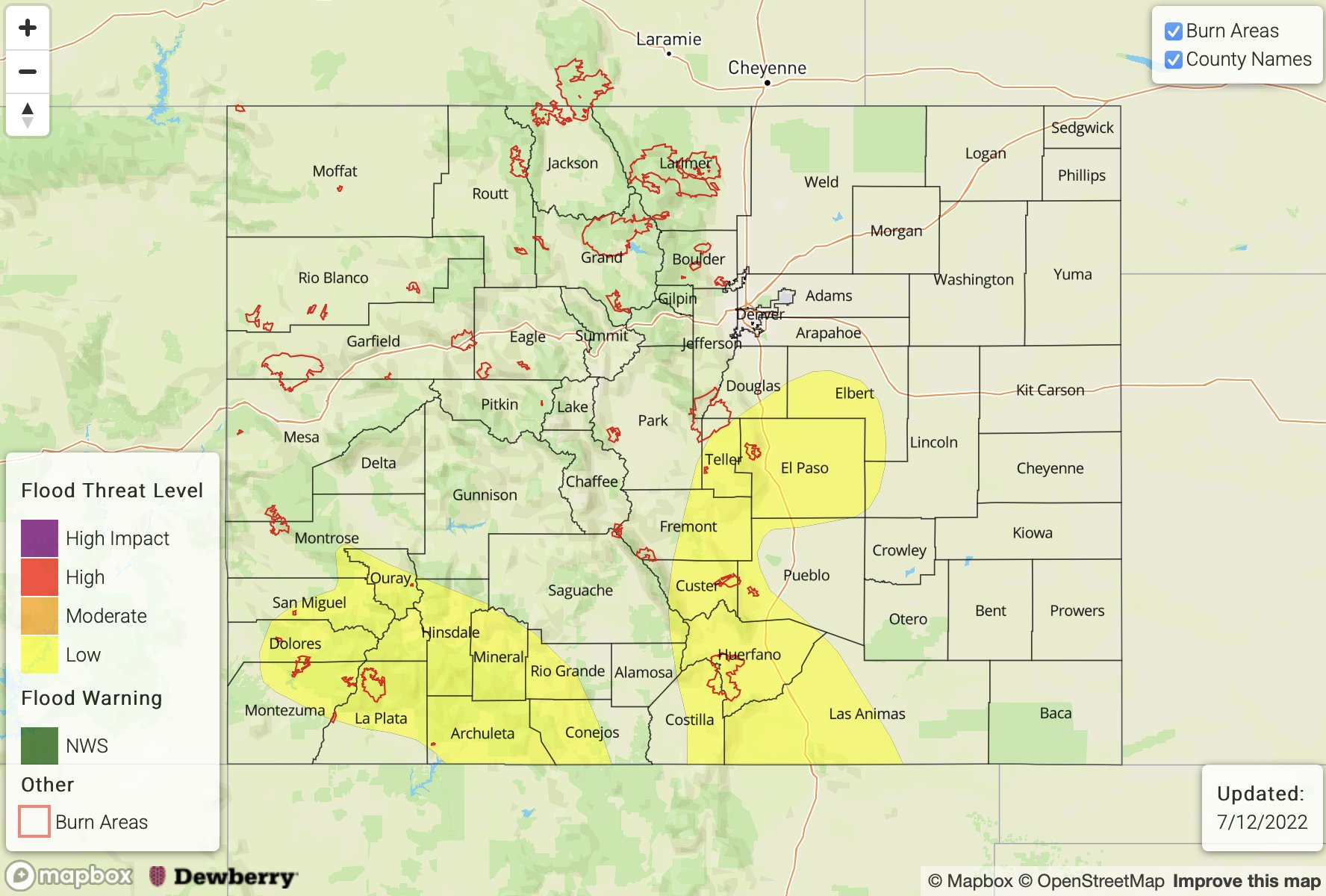
— A LOW flood threat has been issued for the Southeast Mountains, Raton Ridge and portions of the Palmer Ridge, Urban Corridor, Front Range, San Juan Mountains and Southwest Slope
— Fire-Burn Forecast Summary: 3 burn areas under LOW threat; click HERE for more info
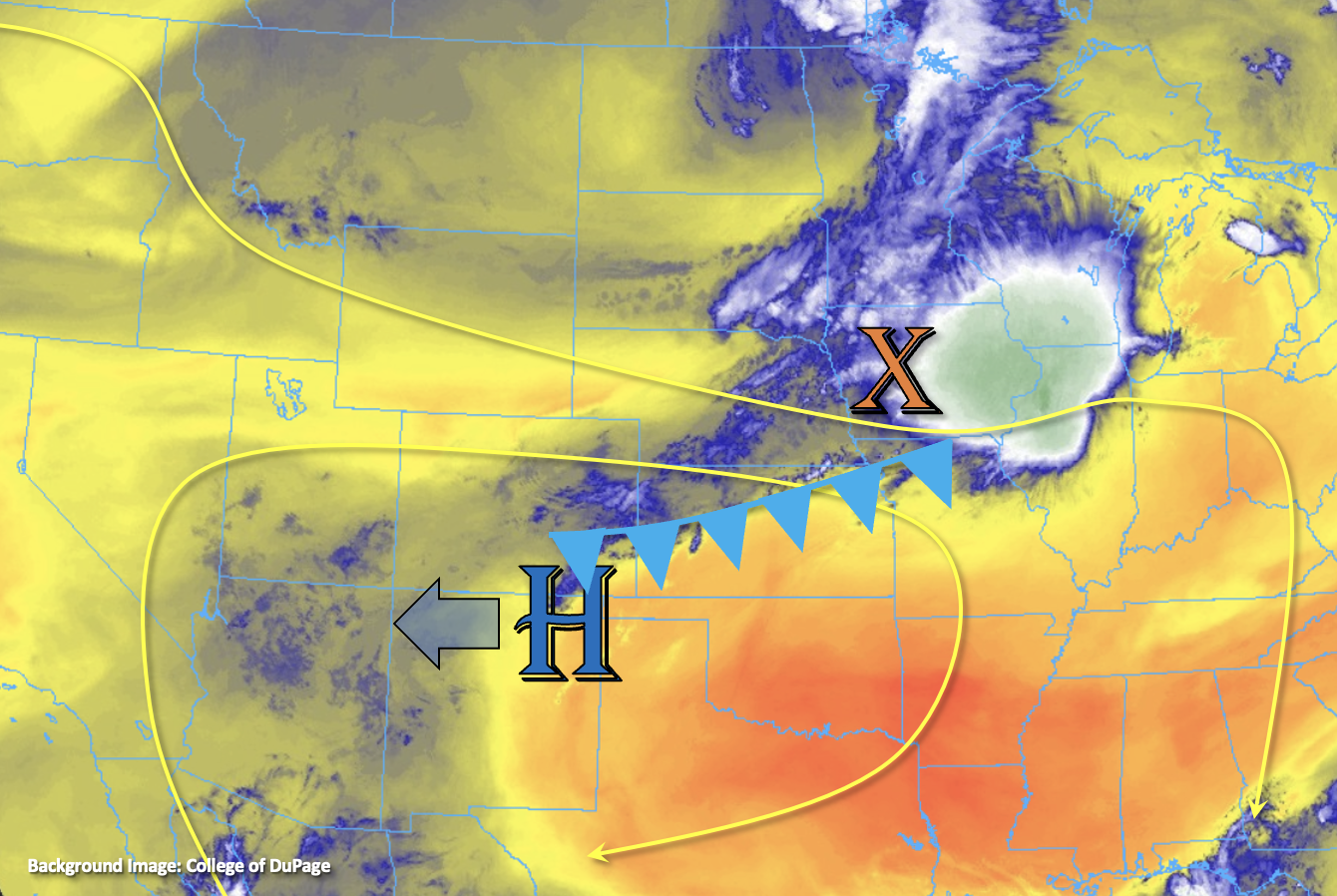
This morning skies are mostly clear across the state thanks to the advection of a drier air mass from the north. There is a small disturbance just west of Colorado (orange “X” below) creating some morning cloud cover with the residual moisture. However, the morning sounding at Grand Junction indicates that this moisture is mostly located around 500mb with the dry boundary layer remaining. PW was measured at 0.75 inches with values increasing towards the southern border, closer to the moisture plume. There was no sounding again at Denver this morning, but it’s likely that PW is around the same as Grand Junction with values estimated around an inch over the far eastern plains. So, while there has been a reduction in the available moisture, there is still plenty left for scattered to numerous storms to develop this afternoon again.
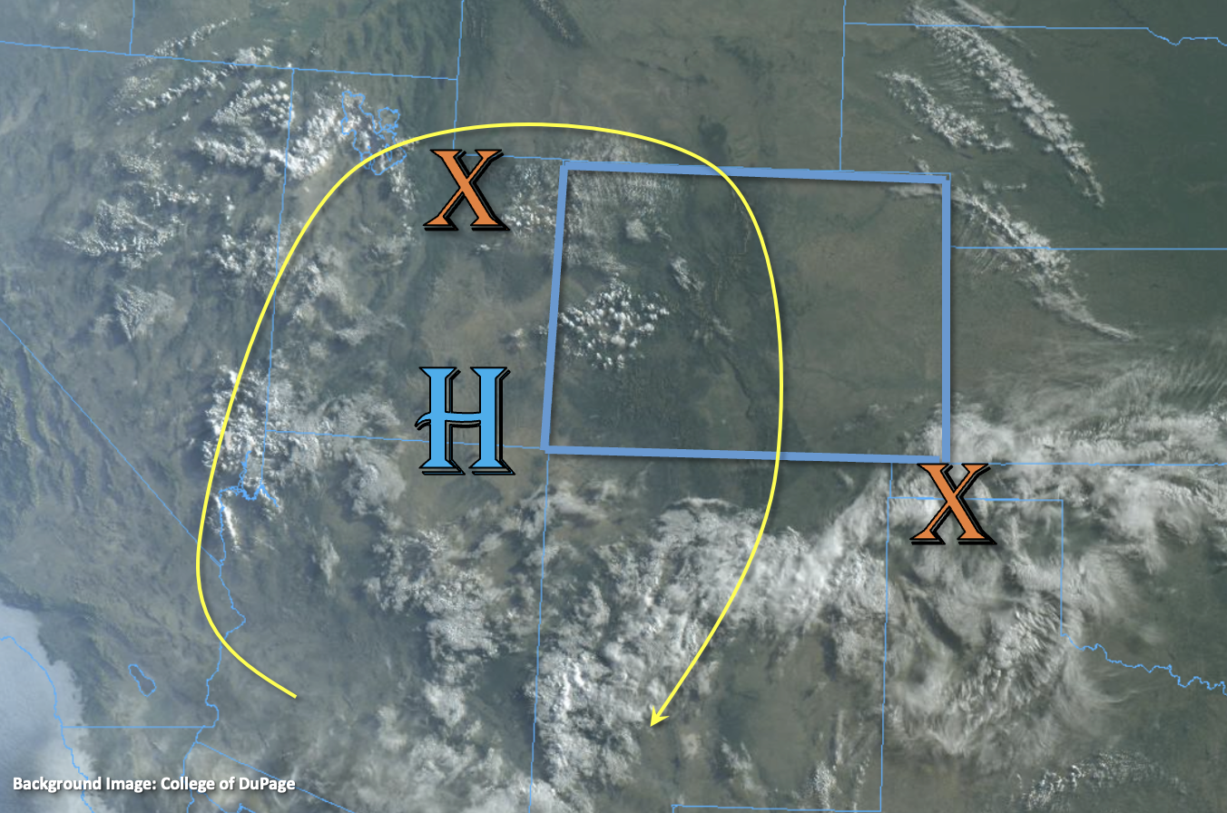
The ridge will continue to build northward today, which will place Colorado under northwesterly flow aloft and help increase afternoon temperatures. Diurnal flow and perhaps some weak mid-level lift will help initiate storms over the high terrains by early afternoon. More activity is forecast over the Front Range and Central Mountains today with some storm activity likely over the adjacent, Northeast Plains as storms roll off the Cheyenne Ridge and mountains. Further south, closer to the moisture plume, storms should be more numerous again. Storm motion should be marginally faster than yesterday and paired with the slight downtick in moisture, this should reduce the flood threat when compared to yesterday. However, isolated thunderstorms over the elevated ridges and southern mountains may still be able to produce local, heavy rainfall under the stronger cores that develop in areas of higher instability. With soils likely saturated from yesterday over the Southeast Mountains and Raton Ridge, there is an increased threat for flooding over the area, mostly regarding runoff. A LOW flood threat has been issued. Scroll down for more details.
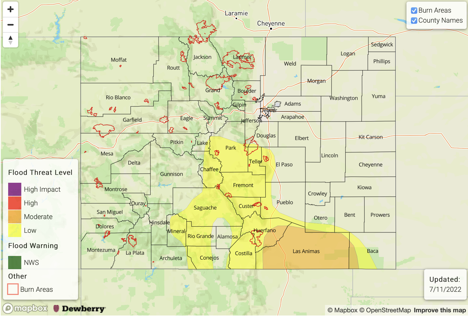
Today’s Flood Threat Map
For more information on today’s flood threat, see the map below. If there is a threat, hover over the threat areas for more details, and click on burn areas to learn more about them. For Zone-Specific forecasts, scroll below the threat map.
Zone-Specific Forecasts:
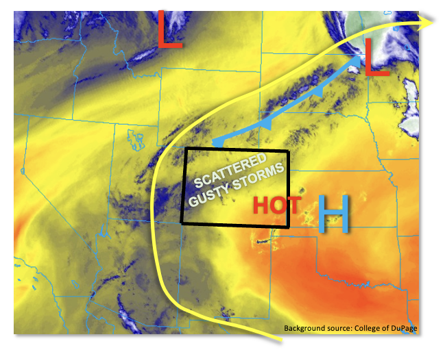
Raton Ridge, Palmer Ridge, Southeast Mountains, Southeast Plains, San Luis Valley, Southwest Slope & San Juan Mountains:
Scattered to numerous storms are forecast today with isolated heavy rainfall possible under the stronger thunderstorms that develop. Small hail and outflow winds may also accompany these stronger storms. Over eastern Colorado, isolated max 1-hour rain rates up to 1.75 inches will be possible. This could cause mud flows and debris slides over steeper terrains and increased runoff and road flooding, especially if storms track over saturated soils. The far eastern plains look to stay dry. Over western Colorado, there should be an uptick in storm coverage today over the high terrains. Isolated max 1-hour rain rates up to 1.5 inches will be possible with training storms or storms that anchor to an area. This could cause isolated mud flows and debris slides as well as road flooding across the steeper terrains. A LOW flood threat has been issued.
Primetime: 11AM to 10PM
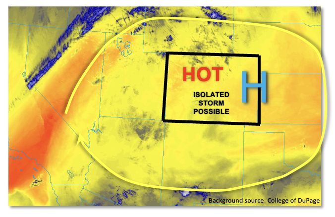
Front Range, Central Mountains, Northern Mountains, Northwest Slope, Grand Valley, Northeast Plains & Urban Corridor:
Storms should be widely scattered (west) to scattered (east) today with max 1-hour rain rates up to 0.4 inches possible over the western high terrains and mountains. A few storms will likely produce some strong outflow winds with the drier surface layer. The Urban Corridor will likely stay dry with downscoping winds forecast. A couple stronger thunderstorms may be possible over the Northeast Plains as storms roll off the mountains and Cheyenne Ridge into higher moisture. Additional storms may develop from their outflow boundaries. Small hail and wind along with max 1-hour rain rates up to 1.5 inches will be possible. Flooding is NOT expected.
Primetime: 12:30PM to 11PM