Issue Date: Sunday, July 10th, 2022
Issue Time: 8:45AM MDT
— Flooding is NOT expected today
Compared to yesterday morning, a much busier weather map is noted over Colorado today as shown in the water vapor image, below. The main feature continues to be a strong upper-level ridge, now centered just to our east. Clockwise circulation along with subsidence will continue to hamper convection today, though mainly over southeast Colorado. An increase in moisture over western Colorado (Grand Junction PW at 0.74 inches compared to ~0.50 inches yesterday), combined with more active synoptic scale dynamics coming in from the north will support scattered shower and storm activity this afternoon and evening across most of the state. This will be welcome news given that very hot afternoon temperatures are expected once again. The good news today is that cloud cover should bring down temperatures quicker by early evening.
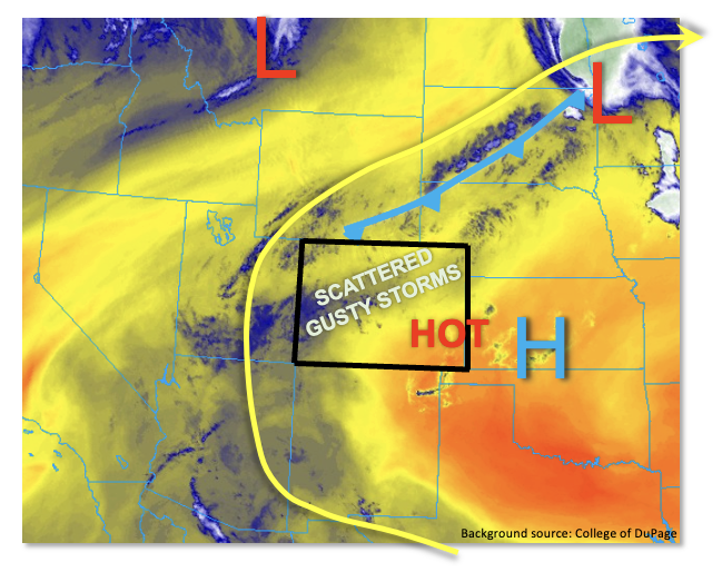
Focusing on details, mid-level clouds are already noted over parts of western Colorado as modest monsoon moisture has moved into the state. However, PW is expected to top in the 0.5 – 0.8 inch range as the much higher moisture will be suppressed well south over southern New Mexico and Arizona. With some mid-level cooling associated with a jet stream and cool front to our north, we expect much higher storm coverage today compared to Saturday. However, the combination of limited boundary layer moisture and notably faster steering flow will still act to suppress rainfall accumulation. While short-term moderate intensity downpours are still expected under the strongest storm cores, flooding is NOT expected today. However, gusty storm winds are expected basically statewide this afternoon and evening as storms increase in coverage.
Today’s Flood Threat Map
For more information on today’s flood threat, see the map below. If there is a threat, hover over the threat areas for more details, and click on burn areas to learn more about them. For Zone-Specific forecasts, scroll below the threat map.

Zone-Specific Forecasts:
Front Range, Urban Corridor, Palmer Ridge, Southeast Mountains, Raton Ridge, Northern Mountains, Central Mountains, Grand Valley, San Juan Mountains, Southwest Slope, San Luis Valley & Northwest Slope:
Becoming partly to mostly cloudy and continued hot with isolated to scattered showers and storms expected this afternoon. Highest coverage will be over the southern and central higher terrain. Max 30-minute rainfall up to 0.5 inches possible along with max 1-hour rainfall up to 0.7 inches. Gusty winds of 30-50 mph or even higher with the strongest cells. Flooding is NOT expected today.
Primetime: 11AM to 8PM
Northeast Plains & Southeast Plains:
Becoming partly cloudy and very hot with isolated to widely scattered storms expected later this afternoon and evening. Highest coverage will be over the Northeast Plains with minimal coverage further south. Max 30-minute rainfall up to 0.9 inches with max 1-hour rainfall up to 1.2 inches. Nuisance street and field ponding is possible but flooding is NOT expected today.
Very gusty winds exceeding 60mph are possible later this afternoon as storms could form a larger complex as they move across the Northeast Plains.
Primetime: 2PM to 11PM