Issue Date: Thursday, August 3, 2017
Issue Time: 10:00AM MDT
— LOW/MODERATE flood threat for portions of the Front Range, Urban Corridor, Palmer Ridge, Central Mountains, Southeast Mountains, Southeast Plains, Raton Ridge
— LOW flood threat for the Southwest Slope, San Juan Mountains
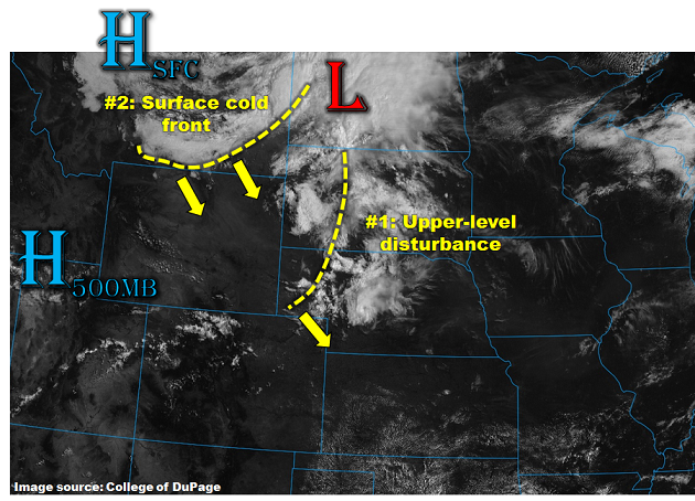
A strong summer cold front passed through the northern portion of the state last night bringing some isolated thunderstorms and much cooler temperatures for today. There are ongoing scattered showers over the eastern plains and central mountains this morning that can be seen in the water vapor imagery below. The showers are located near the cold front and upper-level disturbance, and will continue to move to the SE and exit the state by early afternoon. The cold front helped usher in some low and mid-level moisture east of the Continental Divide. The Precipitable Water (PW) over 1 inch for this afternoon is marked in the map below.
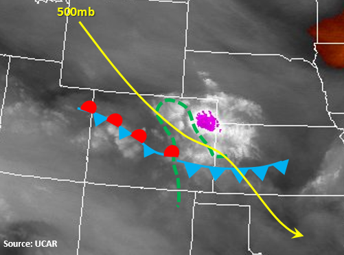
Some of today’s storms will begin to form over the higher terrain midday, while the storms over the Central Mountains will move to the SE and exit the state by early afternoon. Coverage will be more numerous than the previous couple of days favoring the southern Front Range, Southeast Mountains and San Juan Mountains for the heavier precipitation. Storm motion will continue a bit faster to the SE, but the two rounds of precipitation over the SW mountains warrants a Low flood threat. As storms begin to move off the higher terrain, they will favor the higher terrain along the Palmer Divide and Raton Ridge where there will be little convective inhibition and higher instability. There will also be some shear today with the NW upper-level flow that could support a couple severe thunderstorms with 1 inch hail and gusty winds. Flood threats include mud flows, debris slides and small stream and road flooding especially near burn scars. The ongoing showers and associated cloud cover will limit coverage of heavy rainfall over the far eastern plains today. Mainly dry weather is expected over the northwest portion of Colorado.
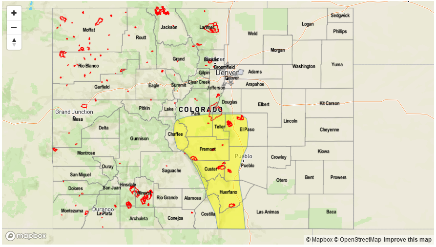
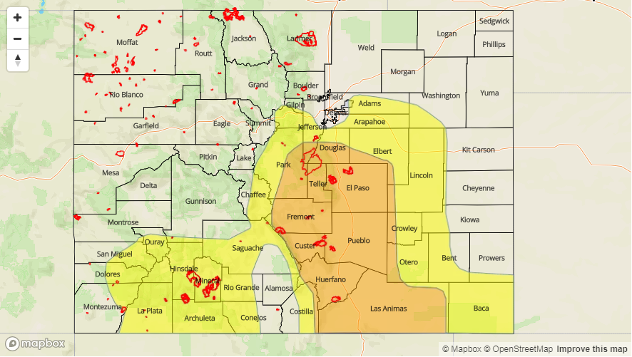
Today’s Flood Threat Map
For more information on today’s flood threat, see the map below (hover over threat areas for more details). For Zone-Specific forecasts, scroll below the map.

Zone-Specific Forecasts:
Front Range, Urban Corridor, Palmer Ridge, Northeast Plains, Southeast Mountains, Raton Ridge, Southeast Plains:
Partly cloudy early then turning more sunny through the day. Expecting scattered showers and thunderstorms to develop over the terrain around midday and last into the early evening hours. Highest coverage will be along the Front Range, Palmer Ridge, Southeast Mountains and Raton Ridge. Storms on the adjacent plains will favor the Palmer Ridge. Max 1-hour rainfall up to 1.8 inches (east) and 1.4 inches (west). A Moderate/Low flood threat has been issued for today.
Primetime: 1PM to 10PM
Northwest Slope, Grand Valley, Southwest Slope, Northern Mountains, Central Mountains, San Juan Mountains, San Luis Valley:
Ongoing showers continue over the Central Mountains as they move to the SE. Mostly sunny and pleasant today with the cooler temperatures over the NW portion of the state. Scattered thunderstorms expected throughout the afternoon over the San Juan Mountains with 24-hour totals up to 2 inches. Max 1-hour rainfall up to 0.5 inches (north) and 0.7 inches (south). A Low flood threat has been issued for the 24-hour totals.
Primetime: 10AM to 10PM