Issue Date: Tuesday, August 1, 2017
Issue Time: 9:50AM MDT
— Flooding is NOT expected today
After a very long stretch of heavy rainfall somewhere across Colorado, we are in store for a break today. On a side note, we have issued a flood threat for the past 21 days in a row, which is the longest such stretch that we can remember!
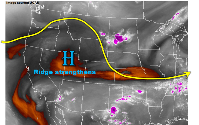
The water vapor image, below, shows that an upper-level ridge, currently centered just west of Colorado, will intensify today. The implication for our weather will be subsidence and some modest drying. Precipitable water this morning range from 0.5 – 0.9 inches and will continue to drop a bit further. This will partially be offset by very wet soils that will evaporate into the boundary layer and keep moisture higher than it would otherwise be. Marginal instability will develop this afternoon in far eastern Colorado, and an isolated thunderstorm is possible. One or two of the storms could briefly turn severe (large hail is the main threat). However, flooding is not expected today.
With the recent string of rainfall in southeast Colorado, the Arkansas River and its tributaries remain elevated. The Purgatoire River is particularly high after a pronounced river crest formed late Sunday. This morning’s analysis suggests the river peaked earlier today in the “Action” level, and it is expected to stay below Minor flood stage.
Looking out further, a strong surface high pressure system is set to move into Colorado starting Wednesday afternoon. It will usher in a fall-like cool front that will briefly interrupt summer. High temperatures on Thursday could end up being as much as 20F below normal for parts of eastern Colorado.
Today’s Flood Threat Map
For more information on today’s flood threat, see the map below (hover over threat areas for more details). For Zone-Specific forecasts, scroll below the map.

Zone-Specific Forecasts:
Front Range, Urban Corridor, Palmer Ridge, Northeast Plains, Southeast Mountains, Raton Ridge, Southeast Plains:
Sunny early then a partly cloudy with an isolated thunderstorm possible in the higher terrain as well as far eastern areas. Max 1-hour rainfall 0.4 inches (west) and 0.7 inches (east). For eastern areas, the strongest cells could briefly turn severe, with hail up to 1.25 inches possible. Flooding is not expected today.
Primetime: 1PM to 8PM
Northwest Slope, Grand Valley, Southwest Slope, Northern Mountains, Central Mountains, San Juan Mountains, San Luis Valley:
Mostly sunny and pleasant today with isolated to scattered showers and perhaps a weak thunderstorm possible especially across southern areas. Max 1-hour rainfall up to 0.4 inches. Flooding is not expected today.
Primetime: 12PM to 8PM