Issue Date: Wednesday, August 2nd, 2017
Issue Time: 10:30AM MDT
— Flooding is NOT expected today
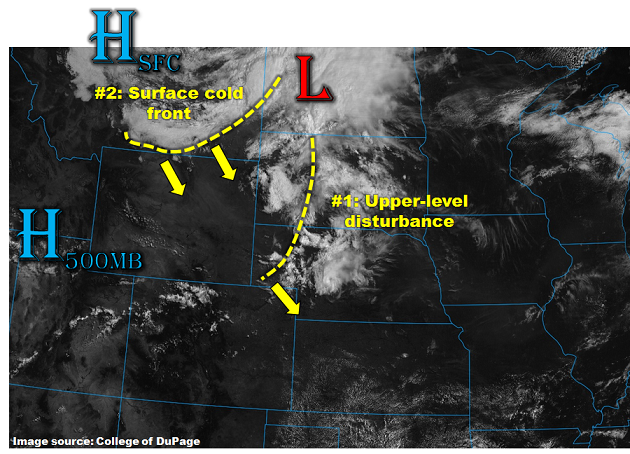
After a brief pause in the action on Tuesday, more active weather is expected over the next 24-36 hours. However, for today, this is not expected to result in a flood threat. As shown in the visible satellite image, below, a weak surface low pressure is located in the northern Great Plains this morning. Associated with this feature is a modest strength mid-level disturbance, currently supporting mid-level clouds over central and western Nebraska. As this disturbance moves quickly to the south and east, it will graze mainly the northeast quadrant of Colorado. An increase in rainfall coverage and intensity is expected this afternoon and evening to the north and east of the Palmer Ridge. However, rain rates are expected to stay below flood threat thresholds.
Looking farther northwest, a 1032mb surface high pressure, very strong for this time of year, is developing to the lee of the southern Canadian Rockies. An accompanying strong surface cold front is expected to enter northeast Colorado later this evening. The main sensible impacts will be a secondary shot of shower and thunderstorm activity, and an increase in low-level moisture. However, with limited instability, relatively fast SSE steering winds and only a shallow easterly component of storm inflow, max rain rates with this activity are also expected to stay below flood threat levels.
Much cooler temperatures are expected tomorrow for northeast Colorado, with an increase in heavy rainfall across southeast Colorado where instability will be present. Mainly dry weather is expected to the west of the Continental Divide.
Today’s Flood Threat Map
For more information on today’s flood threat, see the map below (hover over threat areas for more details). For Zone-Specific forecasts, scroll below the map.
Zone-Specific Forecasts:
Front Range, Urban Corridor, Palmer Ridge, Northeast Plains, Southeast Mountains, Raton Ridge, Southeast Plains:
Sunny early then turning partly cloudy with isolated to scattered showers and thunderstorms developing in the early afternoon, lasting into the early evening. Highest coverage will be along the Front Range and also towards the KS/NE borders. Max 1-hour rainfall up to 1.2 inches (east) and 0.7 inches (west). A secondary increase in precipitation is expected during the late evening as a cold front moves into Colorado. Max 1-hour rainfall up to 1.0 inches (east) and 0.7 inches (west) will be possible with this activity. Flooding is not expected today.
Primetime: 12PM to 2AM
Northwest Slope, Grand Valley, Southwest Slope, Northern Mountains, Central Mountains, San Juan Mountains, San Luis Valley:
Mostly sunny and pleasant today with isolated showers and weak thunderstorms over the higher terrain. However, scattered thunderstorms will be possible over the San Juans. Max 1-hour rainfall up to 0.3 inches (north) and 0.6 inches (south). Flooding is not expected today.
Primetime: 12PM to 8PM