Issue Date: 6/23/2018
Issue Time: 8:40 AM
A LOW FLOOD THREAT IS ISSUED FOR PORTIONS OF THE URBAN CORRIDOR, PALMER RIDGE, NORTHEAST PLAINS AND SOUTHEAST PLAINS FROM 3 PM – 11 AM TOMORROW.
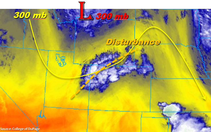
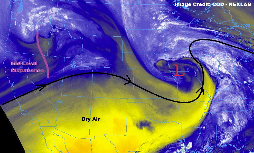
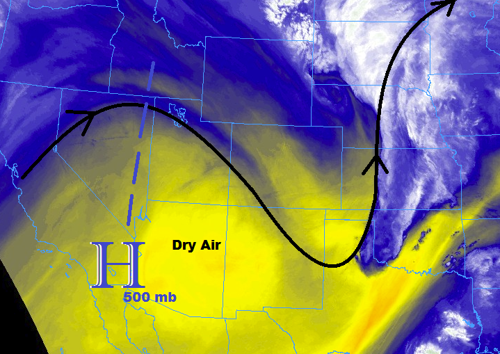
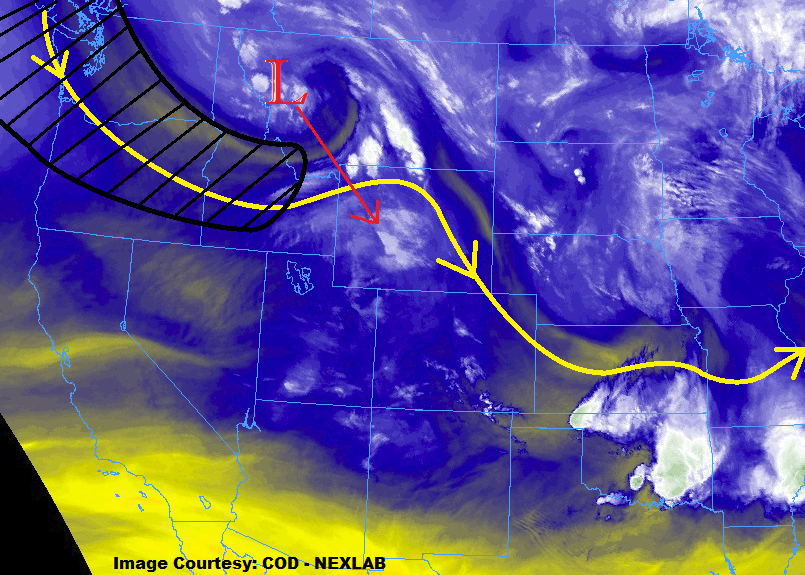
The main focus of this FTB period’s forecast is an upper-level low, currently situated over Northeastern Idaho/western Montana, that will dig southeastward through today and tonight, becoming centered over western Wyoming around midnight tonight. This movement will place a jet streak (black-hatched area in water vapor image below) in a favorable position to produce lift and trigger thunderstorms over Colorado later today and continuing into tomorrow. At the surface, a cold front will pass through the state tonight and early tomorrow, with increasing moisture behind the front and east of the mountains. This will set the stage for the low flood threat that has been issued, as deeper moisture coincides with the broad-scale lift brought on by the upper-low and jet streak.
Prior to this period’s “main event” described above, a few isolated showers and thunderstorms are expected this afternoon/evening thanks to daytime heating and residual moisture. Activity west of I-25 will produce more gusty winds than rain, as low-level moisture will be a bit too low for anything more. For areas east of I-25, isolated thunderstorms will have access to better moisture and better wind profiles, so a couple strong-to-severe storms cannot be ruled out. These storms will be capable of periods of heavy rainfall, strong winds, and small hail. Relatively quick eastward storm motions will mitigate heavy rainfall residence time over an area, so street/field ponding in poorly drained areas will be only concern with heavy rainfall during this time frame.
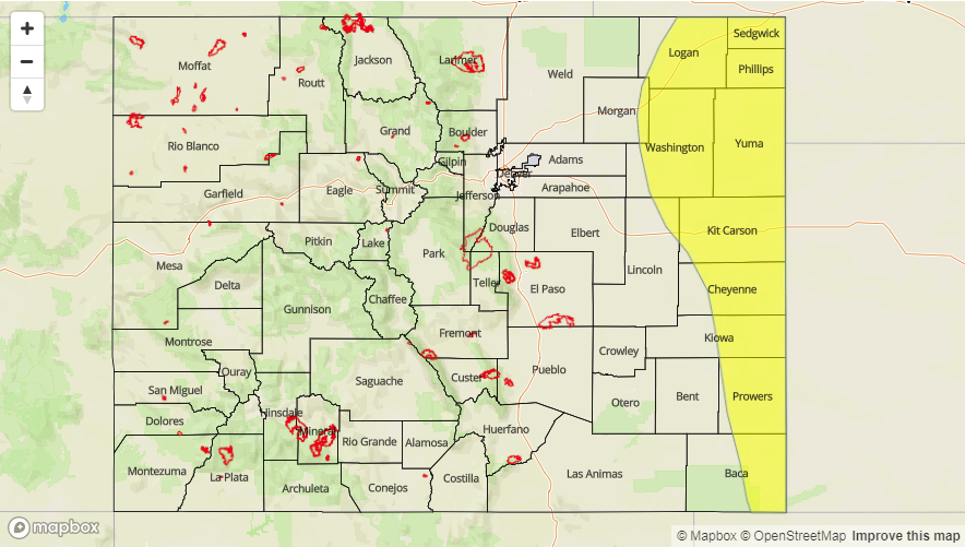
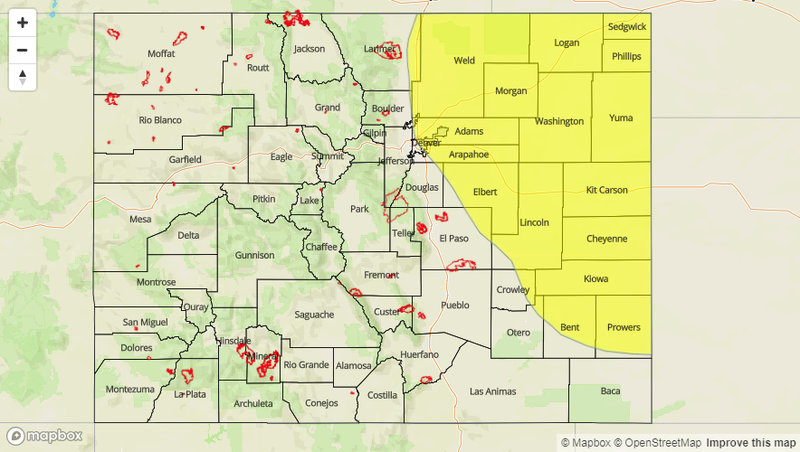
Today’s Flood Threat Map
For more information on today’s flood threat, see the map below (hover over threat areas for more details). For Zone-Specific forecasts, jump below the map.

Zone-Specific Forecasts
Front Range, Urban Corridor, Palmer Ridge, Northeast Plains, Southeast Mountains, Raton Ridge, and Southeast Plains:
A few isolated thunderstorms expected this afternoon/evening (3 PM – 7 PM) triggered by daytime heating. Later this evening and into tomorrow morning (6 PM – 11 AM), the influence of an upper-level low, jet streak, and moisture return behind a surface cold front will allow for the development of scattered showers and thunderstorms, mainly north of a line from Kit Carson to Colorado Springs. The bulk of the thunderstorm activity is expected north of Highway 36. Maximum rain rates are as follows:
Urban Corridor: 0.5-1.0 inches/hour
Northeast Plains and Southeast Plains: 1.4-2.0 inches/hour
Raton Ridge: 0.5-0.8 inches/hour
Front Range: 0.25-0.5 inches/hour
Southeast Mountains: 0.05-0.15 inches/hour
The main threats will be street/field ponding in poorly drained areas, flooding of low-lying areas and intersections, and small stream/creek flooding.
Timing: 3 PM – 11 AM
Northern Mountains, Central Mountains, Northwest Slope, Grand Valley, San Juan Mountains, San Luis Valley, and Southwest Slope:
Mostly sunny, breezy, and hot for most areas today, with Red Flag Warnings in effect across much of the region until 9 PM tonight. A few isolated showers/weak storms are expected over the higher elevations of the Northwest Slope, Northern Mountains, and northern portions of the Central Mountains later this afternoon (thanks to daytime heating), with a few continuing into the overnight hours thanks to the upper-level low and jet streak. Moisture remains too low for any flood threat, and more wind than rain is expected from any activity. Maximum rain rates will be 0.05-0.15 inches/hour.
Timing: 3 PM – Midnight