Issue Date: Friday, June 22, 2018
Issue Time: 9:30AM MDT
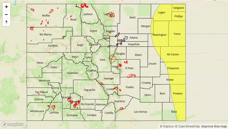
— A LOW flood threat has been issued for the Northeast Plains, Southeast Plains and eastern Palmer Ridge
Taking a look at the low level water vapor imagery below, the first upper trough described in yesterday’s FTO can be seen over the MT/WY border. The upper jet associated with this feature is producing strong westerly flow over Colorado and helping produce the shortwave (disturbance) marked in the image below. This is currently generating high cloud cover and some very light showers over the northwest corner of the state. This trough will continue to move eastward across the state today and help produce severe weather over the eastern plains. Threats include very large hail, strong winds and local, heavy rainfall. To the west, a tightening gradient and weak front will increase surface winds. The lack of low level moisture (Grand Junction PW at 0.52 inches) will produce critical fire weather; thus, a Red Flag Warning has been issued through this evening.
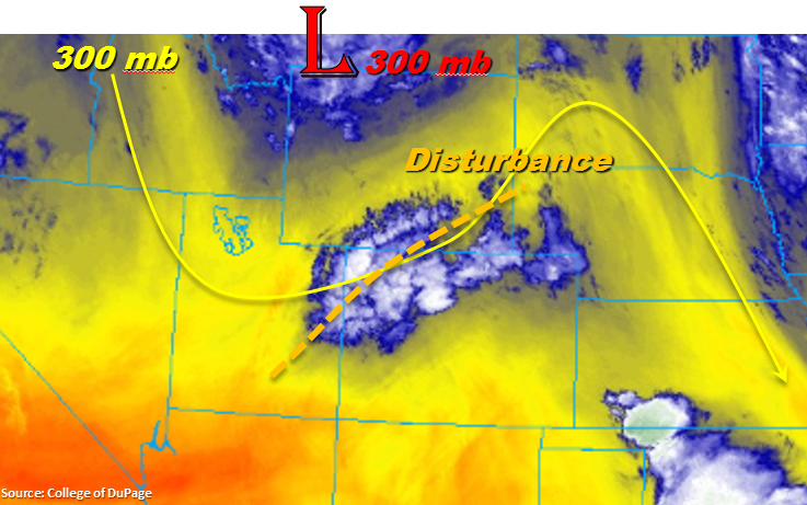
Over eastern Colorado, the shortwave trough will help promote more widespread showers and thunderstorm development over the Front Range and Southeast Mountains this afternoon. However, with dry upper levels and downsloping winds, these storms will produce more gusty winds than measureable rainfall. As the disturbance arrives to the plains during peak heating, favorable severe weather parameters will have set up. A lee cyclone will have helped pull in high low level moisture with easterly flow increasing CAPE values, decent shear will have developed thanks to westerly flow aloft and a nice SW to NE convergence boundary will provide lift for the severe thunderstorms. Hodographs indicate a low tornado threat, and instead the atmosphere is expected to produce a line of convection capable of generating strong winds and very large hail. Although storm motion will be fairly quick to the E/SE, with dew points in the upper 50Fs to 60Fs, heavy, local rainfall is possible. A Low flood threat has been issued for road and small stream flooding, arroyo flooding and field ponding.
Today’s Flood Threat Map
For more information on today’s flood threat, see the map below. For Zone-Specific forecasts, scroll below the map.

Zone-Specific Forecasts:
Northeast Plains, Southeast Plains, Palmer Ridge:
Expecting severe thunderstorms this afternoon with very large hail and strong winds. With high dew points, a quick 1.75 inches in an hour is possible closer to the KS/CO border and over the northeast corner of the state. Storms will move quickly to the E/SE and exit the region by 9PM this evening, but there may be some showers that wander into the plains through midnight. A Low flood threat has been issued for road flooding, small stream flooding and field ponding for the line of convection this afternoon.
Primetime: 12PM to 9PM
Front Range, Urban Corridor, Southeast Mountains, Raton Ridge:
Expecting increased shower and thunderstorm coverage over the mountains this afternoon with the passing shortwave. Storms will likely produce gusty winds as there will not be much moisture available for measureable rainfall. Max 1-hr rain rates up to 0.15 inches/hour north and 0.25 inches/hour south. Over the adjacent plains max 1-hour rain rates up to 0.6 inches/hour are possible. There is a chance for some lingering showers over the adjacent plains through midnight.
Primetime: 11AM to 9PM
San Luis Valley, San Juan Mountains, Northern Mountains, Southwest Slope, Grand Valley, Central Mountains, Northwest Slope:
As the upper wave continues eastward throughout the day, the cloud cover should decrease over the northwest corner of the state. Expect a few high clouds over the higher terrains this afternoon. Surface winds will also increase with the passing trough and create another day of critical fire weather. Rainfall is not likely outside of light showers this morning over the Northern and Central Mountains.