Issue Date: 6/21/2018
Issue Time: 8:15 AM
NO FLOOD THREAT IS FORECAST TODAY.
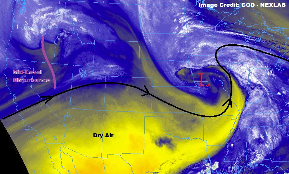
The ridge of high pressure that dominated the forecast yesterday is being flattened today by the approach and passage of a mid-level shortwave (denoted by the purple line in the water vapor image below). This will result in the development of a few more isolated-to-widely thunderstorms this afternoon/evening, mainly along/east of the Continental Divide. Westerly flow aloft will work against the potential for heavy rainfall today in two ways: 1) it will keep better moisture further east over the plains, and 2) storms will move quickly towards the east, reducing the residence time of any periods of rainfall over a particular location.
West of the Continental Divide, a couple of high-based, isolated showers/weak thunderstorms cannot be ruled out over the Northwest Slope, Northern Mountains, and northern portions of the Central Mountains, where the close(r) proximity to the mid-level disturbance will provide enough lift for the development of said activity. Moisture will remain on the lower end of the scale, so any showers/storms will produce more wind and virga than rainfall. Other than that, western Colorado will remain dry and mostly sunny.
Today’s Flood Threat Map
For more information on today’s flood threat, see the map below (hover over threat areas for more details). For Zone-Specific forecasts, jump below the map.


Zone-Specific Forecasts
Front Range, Urban Corridor, Palmer Ridge, Northeast Plains, Southeast Mountains, Raton Ridge, and Southeast Plains:
Isolated-to-widely scattered thunderstorms are expected this afternoon/evening, first developing over the mountains, then progressing eastward over the lower elevations with time. The strongest storms will occur over northern portions of the Urban Corridor, Palmer Ridge, and Northeast Plains, where low-level moisture will be best (dewpoints in the 50s). A brief period of heavy rainfall in these locations may result in localized street/field ponding, but storm motions will be too quick to necessitate the issuance of any flash flood threat. Maximum rain rates are as follows:
Front Range: 0.25-0.5 inches/hour
Urban Corridor, Northeast Plains, and Palmer Ridge: 0.8-1.2 inches/hour
Southeast Plains: 0.6-1.0 inches/hour
Raton Ridge: 0.3-0.5 inches/hour
Timing: 3 PM – 10 PM, with the any lingering activity diminishing/exiting the state by Midnight
Northern Mountains, Central Mountains, Northwest Slope, Grand Valley, San Juan Mountains, San Luis Valley, and Southwest Slope:
Mostly sunny and dry will be the weather story for the vast majority of the area, with only a couple isolated showers/weak thunderstorms expected over higher terrain north of I-70. This includes the Northwest Slope, Northern Mountains, and northern portions of the Central Mountains. Very little rainfall is expected from any activity, as moisture remains on the lower end of the scale. Gusty winds, virga, and lightning will be the most likely outcome. Maximum rain rates will be 0.05-0.10 inches/hour.
Timing: 2 PM – 9 PM