Issue Date: Tuesday, July 17th, 2018
Issue Time: 09:25AM MDT
— A MODERATE flood threat has been issued for portions of the Palmer Ridge, Southeast Plains and Northeast Plains as well as the recent burn scars over the San Juan Mountains and Southeast Mountains
— A LOW flood threat has been issued for the San Juan Mountains, Southeast Mountains, Raton Ridge, Front Range and Urban Corridor
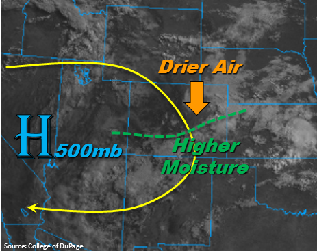
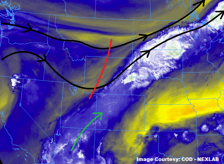
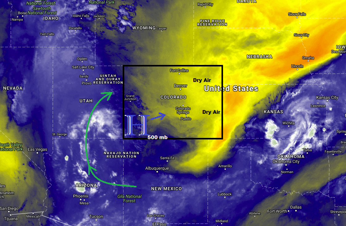
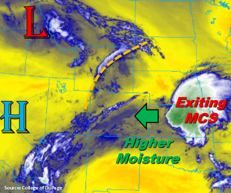
Much cooler start to the day with cloud cover over a large portion of the state thanks to the MCS that moved through the NE panhandle into KS overnight. Today the low pressure over the Pacific Northwest will start to migrate to the east breaking down the ridging pattern to our west. This will push some upper disturbances (marked in orange) over the state, which will provide lift for more widespread thunderstorm activity this afternoon. Over the eastern plains, low level easterly winds will pull in plentiful moisture with dew points reaching the mid 50Fs to 60F later this afternoon. That means paired with sunshine, CAPE will also be able to build throughout the day. So as the storms fire over the higher terrains this afternoon and move into the adjacent plains, they will move into a favorable severe weather environment. Storms are expected to merge into a line, which will be capable of producing large hail and strong winds. With PW values well over 1 inch, (Denver’s sounding had a PW value of 1.15 inches) local, heavy rainfall is expected. A Low and Moderate flood threat have been issued. Storms that track over burn scars should be monitored closely as there is high confidence rain rates will exceed 0.5 inches/hour.
Over the San Juan Mountains, subtropical moisture is able to hold on for one more day. The GEFS is projecting PW values greater than 1 inch this afternoon, which means there is a threat for flash flooding again this afternoon with burn scars being the most susceptible. A Low flood threat has been issued with the recent burn scars under a Moderate flood threat. Storms will likely fire around noon with upslope flow and the flood threat should diminish as instability decreases after sundown. Further north over the Central and Northern Mountains, afternoon thunderstorm activity will be much more isolated. Over the adjacent valleys, a few storms may wander across the border from Utah, but flooding is not expected.
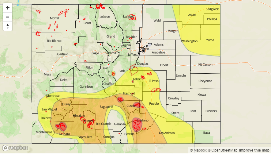
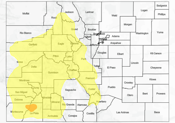
Today’s Flood Threat Map
For more information on today’s flood threat, see the map below. For Zone-Specific forecasts, scroll below the map.

Zone-Specific Forecasts:
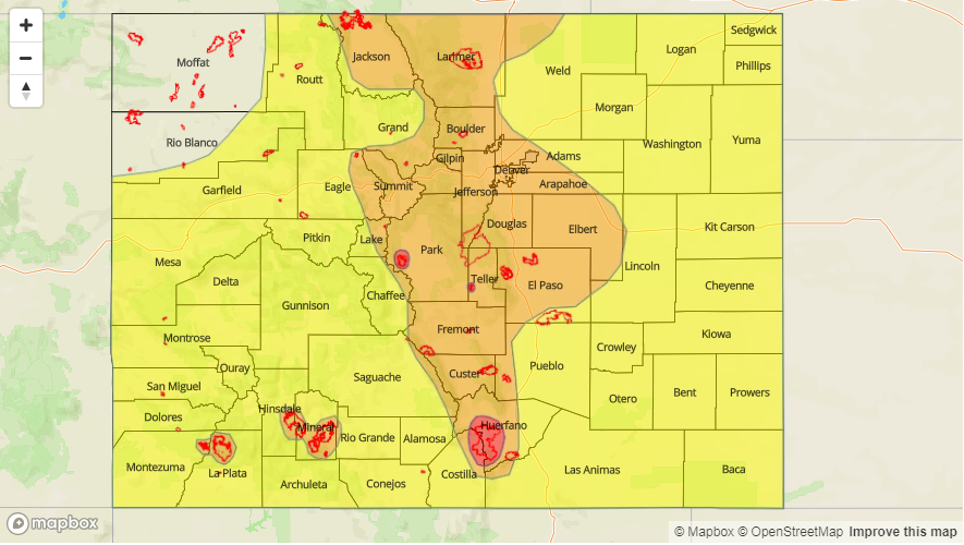
Front Range, Urban Corridor, Palmer Ridge, Southeast Plains, Northeast Plains, Southeast Mountains, Raton Ridge:
Upper disturbance moving in with the low over the Pacific Northwest will help trigger more widespread thunderstorm development this afternoon. With high dew points, the flood threat returns to the Front Range, Southeast Mountains and eastern plains. Max 1-hour rain rates up to 1.1 inches are possible to the west. With deeper moisture over the plains, max 1-hour rain rates up to 2 inches are possible with local totals exceeding 2.3 inches. Threats include local stream and road flooding with debris slides and mud flows possible over the higher terrains. Burn scars will be especially susceptible to flooding, so a Moderate flood threat has been issued for those. A Low/Moderate flood threat has been issued for these regions. Storms over the eastern plains will also be capable of producing large hail and damaging winds.
Primetime: 1PM to 1AM
Southwest Slope, San Juan Mountains, San Luis Valley, Northern Mountains, Grand Valley, Central Mountains, Northwest Slope:
High PW values over the San Juan Mountains means another day for a Low flood threat with a Moderate flood threat for the burn scars. Max 1-hour rain rates up to 1 inch are possible. This could trigger mud flows and debris slides along with local stream flooding. Further north, storms will be more isolated in nature. A couple thunderstorms may move into the lower elevations from Utah. Max 1-hour rain rates will be closer to 0.5 inches/hour. A couple light showers may linger over the San Juan Mountains into the night, but the flood threat will end after sundown.
Primetime: 1PM to 8PM