Issue Date: 7/14/2018
Issue Time: 7:40 AM
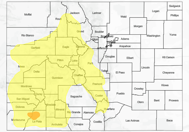
A MODERATE FLOOD THREAT IS FORECAST FOR THE 416 FIRE AND BURRO FIRE BURN AREAS IN THE SOUTHWEST SLOPE AND SAN JUAN MOUNTAINS REGIONS.
A LOW FLOOD THREAT IS FORECAST FOR PORTIONS OF THE SOUTHWEST SLOPE, SAN JUAN MOUNTAINS, GRAND VALLEY, NORTHWEST SLOPE, NORTHERN MOUNTAINS, CENTRAL MOUNTAINS, FRONT RANGE, AND SOUTHEAST MOUNTAINS, WITH THE MAIN FOCUS ON RECENT/ONGOING BURN AREAS.
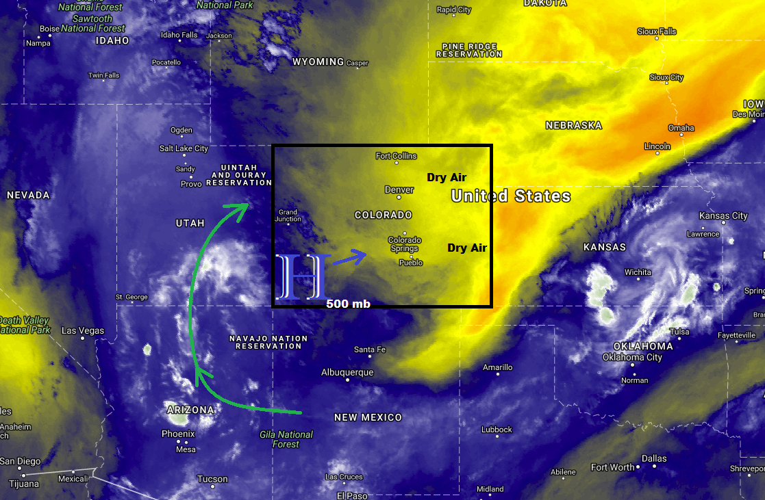
The mid-level high centered over southwest Colorado this morning is expected to shift eastward in response to an approaching mid-level trough today/tonight. This shift will bring moisture currently over Arizona and Utah into western Colorado, setting the stage for another day/night of scattered showers/thunderstorms over the High Country. Due to the depth of moisture associated with the moist plume, heavy rainfall will once again be a threat. Additionally, with the high pressure center centered near the area, steering flow will be weak, meaning showers/thunderstorms will by slow-movers, increasing the residence time of any rainfall. For these reasons, a Moderate Flood Threat has been hoisted for the 416 Fire and Burro Fire burn areas, as well as a broad low threat area across much of the High Country.
To the east of the mountains, temperatures will be on the rise, with high temperatures a few degrees warmer than yesterday’s readings. A couple isolated thunderstorms cannot be ruled out for locations adjacent to the Front Range and Southeast Mountains over the Urban Corridor and western portions of the Northeast/Southeast Plains, or for the preferred terrain of the Palmer Ridge and Raton Ridge. The main threats from any thunderstorm activity will be gusty winds and lightning, with periods of light-to-moderate rainfall. Relatively dry air below cloud bases will evaporate much of the precipitation before it reaches the surface. For more information on rain rates and timing, please see the zone-specific discussions below.
NOTE: Due to technical difficulties beyond our control, the flood threat map today will be a static image and not zoom-able as usual. We apologize for any inconvenience this may cause, and we will do everything we can to have this fixed ASAP.
Today’s Flood Threat Map
For more information on today’s flood threat, see the map below (hover over threat areas for more details). For Zone-Specific forecasts, jump below the map.

Zone-Specific Forecasts
Urban Corridor, Palmer Ridge, Northeast Plains, Southeast Plains, and Raton Ridge:
Mostly sunny and hot, with high temperatures a few degrees warmer than yesterday’s readings. A couple isolated showers/thunderstorms will dot areas near the Front Range/Southeast Mountains over the Urban Corridor and western portions of the Northeast/Southeast Plains, as well as the preferred terrain of the Palmer Ridge and Raton Ridge. The bulk of storm activity will produce more gusty winds than rain due to relatively dry air below cloud bases. Maximum rain rates are as follows:
Northeast Plains: 0.2-0.4 inches/hour
Urban Corridor, Palmer Ridge, and Raton Ridge: 0.3-0.7 inches/hour
Southeast Plains: 0.5-0.9 inches/hour
Timing: 3 PM – 10 PM
Northern Mountains, Northwest Slope, Front Range, Central Mountains, Grand Valley, San Juan Mountains, Southwest Slope, Southeast Mountains, and San Luis Valley:
Scattered showers/thunderstorms are expected today/tonight, beginning around lunchtime, and continuing into the nighttime hours as a weak disturbance keeps showers (and a few thunderstorms) going well past sunset. Relatively slow storm motions and the deep moisture plume require the issuance of a moderate flood threat area for the sensitive burn scars of the 416 Fire and Burro Fire, with a broad low threat area for much of the High Country (with the focus on burn scars). Maximum rain rates are as follows:
Northwest Slope and Northern Mountains: 0.4-0.8 inches/hour
Grand Valley, Southwest Slope, Central Mountains, and San Juan Mountains: 0.6-1.2 inches/hour
Front Range and Southeast Mountains: 0.4-0.6 inches/hour
San Luis Valley: 0.2-0.4 inches/hour
Timing: Noon – Midnight, with a few lingering showers into the early morning hours over the higher terrain of the Southwest Slope, San Juan Mountains, Grand Valley, and Central Mountains regions.