Issue Date: Monday, July 16, 2018
Issue Time: 09:20AM MDT
— A HIGH flood threat has been issued for the Burro/416, Spring Creek, Junkins and Hayden Pass burn scars
— A MODERATE flood threat has been issued for the San Juan Mountains, Southeast Mountains, Raton Ridge and Chateau burn scar
— A LOW flood threat has been issued for the Northeast Plains, portions of the Front Range, Urban Corridor and Palmer Ridge and Weston Pass burn scar
After a busy night of ongoing thunderstorms and moderate rainfall, there will be some fog and lingering showers to start this morning. The thick fog can be seen the visible satellite imagery below as well as some of the rain showers over the Southeastern Plains. Both should begin clearing after some heating later this morning. Today, some drier air begins to make its way in from the north. It won’t quite make it to southern Colorado, so the subtropical moisture will remain south of the green axis in the image below.
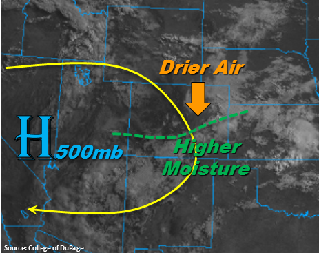
Under the influence of the ridge (slow steering winds), this will allow for another round of heavy rainfall over the southern mountains and Raton Ridge with more isolated activity over the Southeast Plains. Between the high moisture and antecedent rainfall, burn scars will be susceptible to flash flooding again today, which includes mud flows and debris slides. A High/Moderate flood threat has been issued for the higher terrains and burn scars. The entrainment of the dry air should limit rainfall totals on the north side of the moisture axis, but still expect showers and thunderstorms over the northern mountains this afternoon. The storms to the north will be more isolated in coverage when compared to yesterday and will produce some gusty winds. Though more isolated and less intense, thunderstorms that track near fresh burn scars should be monitored closely as it can take as little as 0.25 inches/hour to trigger flash flooding. Thus, a Low flood threat has been issued for the Weston Pass burn scar.
Lastly, a shortwave will move near or across the northeast corner of the state overnight, which would bring a line of organized convection to the Northeast Plains. Threats include severe hail and gusty winds after 11PM with local, heavy rainfall. With high PW values and slow moving storms there is the potential for flash flooding. A Low flood threat has been issued for this area.
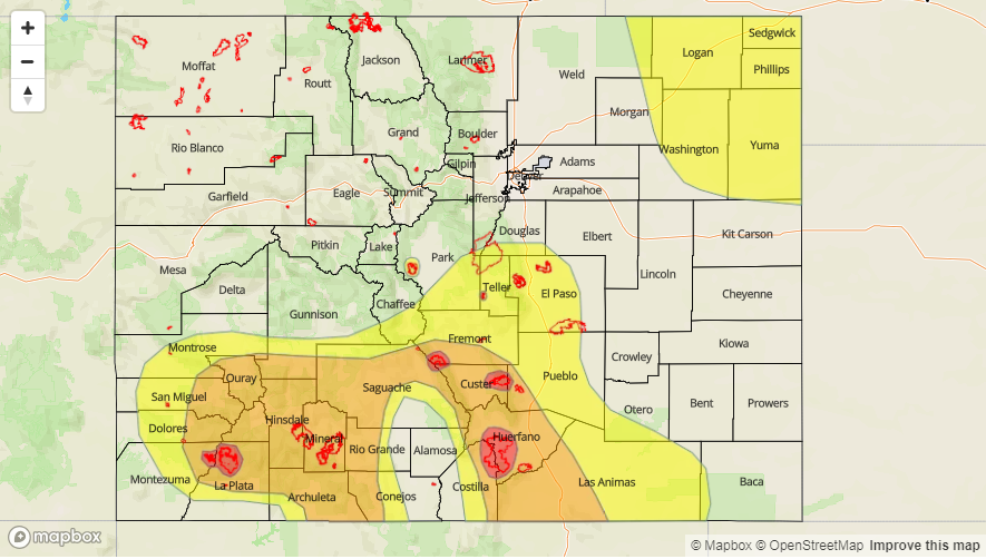
Today’s Flood Threat Map
For more information on today’s flood threat, see the map below. For Zone-Specific forecasts, scroll below the map.

Zone-Specific Forecasts:
Front Range, Urban Corridor, Northern Mountains, Grand Valley, Central Mountains, Northwest Slope:
Drier air will begin to work its way in from the north, which should lower rainfall rates this afternoon over the higher terrains. Max 1-hour rain rates up to 1 inch are possible across the southern Front Range and Urban Corridor, so a Low flood threat has been issued. Threats include local stream and road flooding with debris slides and mud flows possible over the higher terrains. Burn scars will be especially susceptible to flooding. A Low flood threat has been issued for portions of some of these regions. Elsewhere over the high terrains, max 1-hour rain rates will be closer to 0.5 inches.
Primetime: 1PM to 11PM
Southwest Slope, San Juan Mountains, San Luis Valley, Southeast Mountains, Raton Ridge:
Subtropical moisture remains over southern Colorado, and with slow steering winds, heavy rainfall is likely again this afternoon. Special attention should be shown to burn scars in this area as mud flows and debris slides are likely. Max 1-hour rain rates up to 1.2 inches/hour are possible, so flash flooding is likely over this area along with mud flows and debris slides – especially with antecedent moisture. Showers and thunderstorms may linger overnight, but the flood threat should not. A Moderate flood threat has been issued.
Primetime: 1:00PM to Midnight
Palmer Ridge, Southeast Plains, Northeast Plains:
More isolated showers are expected this afternoon over the eastern plains. Overnight, a shortwave and associated convection may move over the northeast portion of the state. Should this occur, this would bring max 1-hour rain rates of 2 inches/hour. Slow storm motion and high moisture would lead to local totals exceeding 3 inches. A Low flood threat has been issued for flash flooding of streams and low-lying roads. Isolated showers and thunderstorms may linger through early tomorrow morning.
Primetime: 11PM to 8AM