Issue Date: Friday, July 26th, 2019
Issue Time: 8:50AM MDT
— A MODERATE flood threat has been issued for the Spring Creek burn area
— A LOW flood threat has been issued for the Southeast Mountains, Raton Ridge, San Juan Mountains, Central Mountains and the higher terrains of the Grand Valley and Southwest Slope. This includes the Hayden Pass, Junkins, Lake Christine and 416 burn areas.
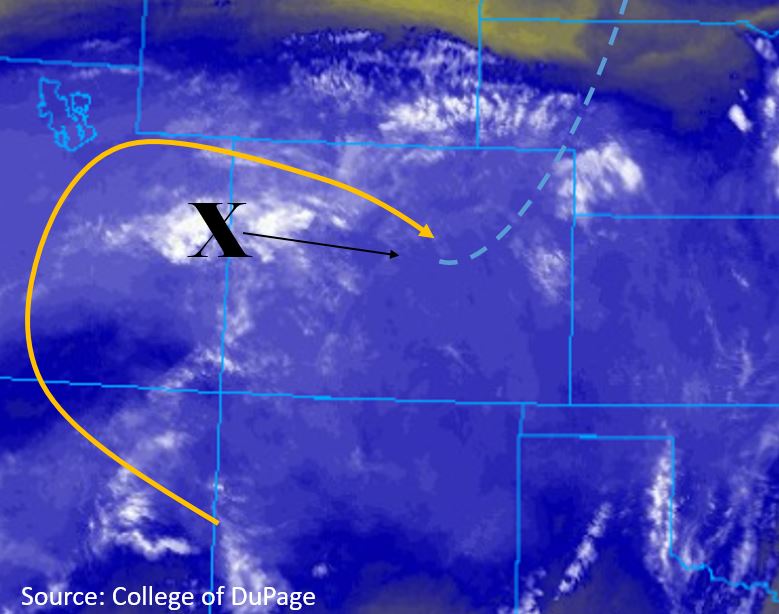
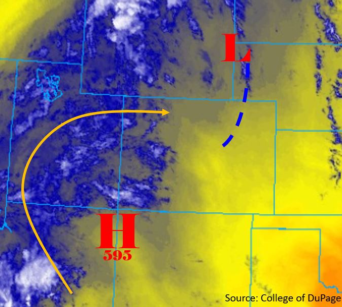
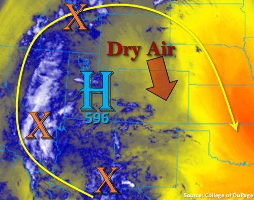
Clear start to the morning over eastern Colorado as some dry air has worked its way into the state with the northwest flow aloft. There is some morning cloudiness over western Colorado from convection yesterday and early this morning associated with the monsoon surge. This will likely limit the instability that can build this afternoon over that area, so expecting more general showers with a slight chance for a couple weak thunderstorms where clouds clear. Marked in the water vapor imagery below are two shortwaves, one that passed through the state yesterday (New Mexico) and the stronger shortwave that will affect tomorrow’s weather as it rotates around the high. The high continues to sit over the NM/AZ border before it gets displaced to the west overnight. The placement of the high is keeping PW values elevated over Grand Junction with this morning’s sounding measuring 1.14 inches, which is slight below yesterday, but still a very moist air mass and above average for this time of year. As anticipated, PW over Denver has dropped off and was measured at 0.65 inches. This should limit the flood threat over the northeast corner of the state, although slow steering winds will still allow for some moderate accumulations.

Storms are expected to initiate with upslope flow by midday; first to the west and then to the east a couple of hours later. Best coverage of afternoon thunderstorms will be over western and southern Colorado. The location of the subtropical high will have storm movement more west to east along the western Colorado border and more to the southeast elsewhere. Slower steering winds will allow for some decent 2 hour accumulations with the moderate rain rates forecast. Paired with three days of rainfall over western Colorado and the Southeast Mountains, soils are rather saturated, so increased runoff is expected this afternoon. A Low flood threat has been issued for these reasons. In addition to the Low threat, a Moderate threat has been issued for the Spring Creek Burn area due to higher confidence rain rates will exceed the 0.4 inch per hour threshold known to trigger flooding, mud flows and debris slides. The threat should end a couple of hours after sundown, although there may be some light, lingering showers over the eastern plains and high country through tomorrow morning.
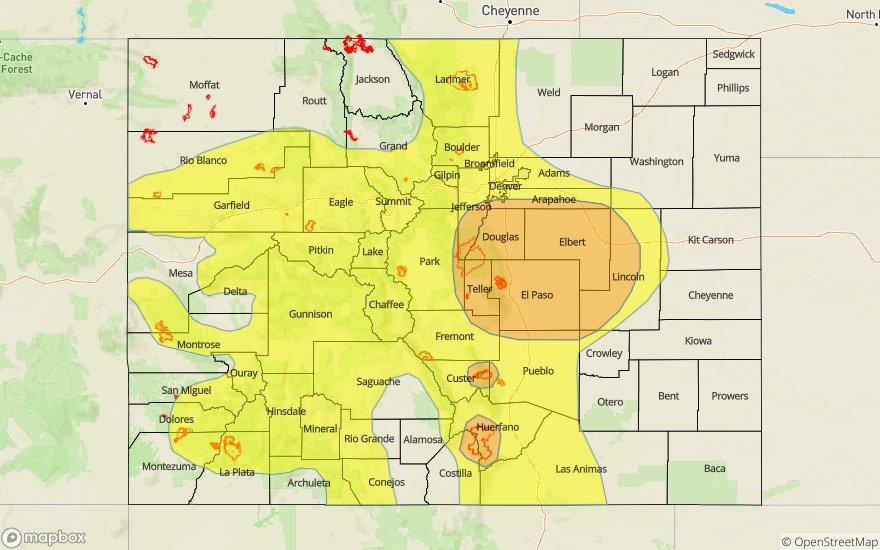
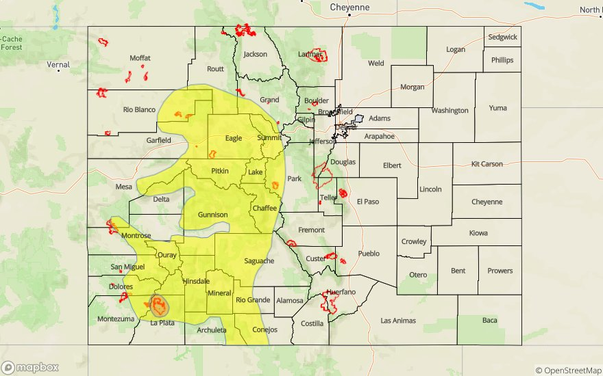
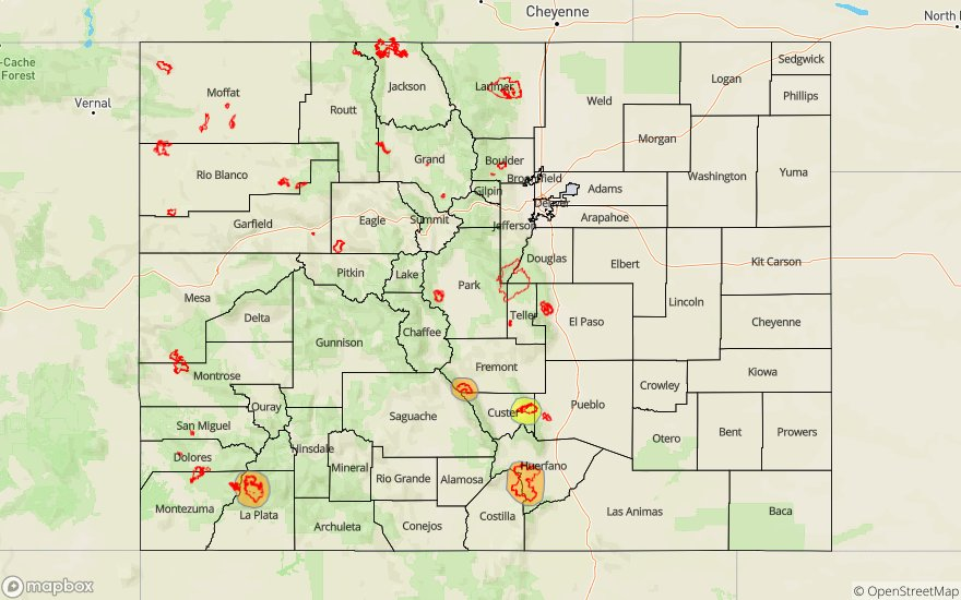
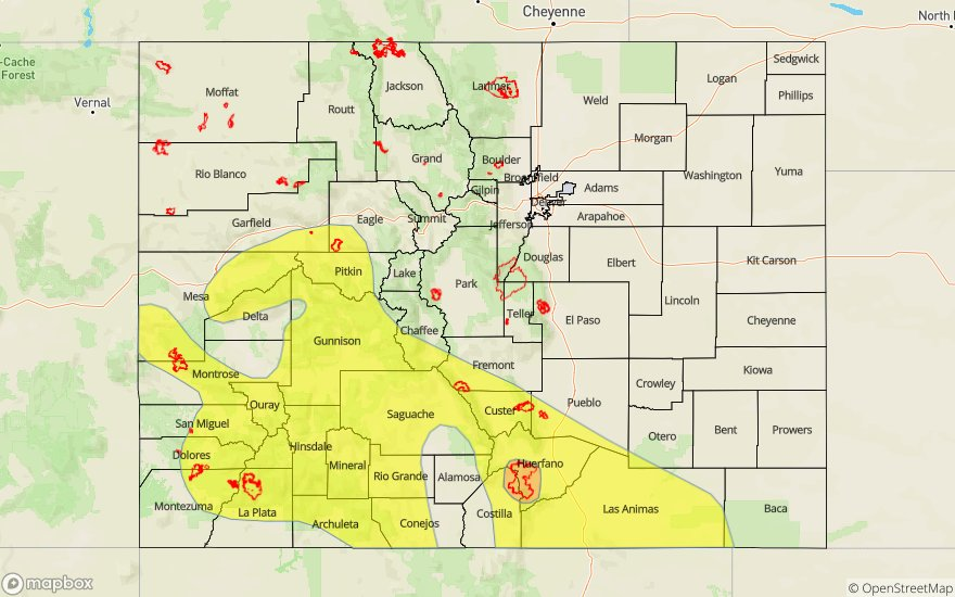
Today’s Flood Threat Map
For more information on today’s flood threat, see the map below. For Zone-Specific forecasts, scroll below the map.

Zone-Specific Forecasts:
Front Range, Urban Corridor, Palmer Ridge, Southeast Mountains, Raton Ridge, Northeast Plains, Southeast Plains:
More scattered storms are expected over the Front Range and Palmer Ridge today with the majority of the action further south were a moister air mass remains in place. A couple of storms may sneak over the Northeast Plains northern border from the Cheyenne Ridge later in the evening. Max 1-hour rain rates up to 0.7 inches will be possible with these storms. Back to the west, 1-hour rain rates between 0.15 and 0.25 inches are forecast for the aforementioned zones. Over the Southeast Mountains and Raton Ridge, max 1-hr rain rates up to 0.75 inches are possible with 2 hour totals up to 1.1 inches along the Raton Ridge. Threats today over the higher terrains include mud flows, debris slides and flash flooding of local streams and creeks. Over the Raton Ridge, field ponding, road flooding and local stream and creek flash flooding will be possible. A Low flood threat has been issued with a Moderate flood threat for the Spring Creek burn area. The Low threat over the Hayden Pass and Junkins burn areas should suffice, but please note there is a Flash Flood Watch for the Spring Creek, Junkins and Hayden Pass burn areas through this evening.
Primetime: 2PM to 11PM
Northwest Slope, Grand Valley, Southwest Slope, Northern Mountains, Central Mountains, San Juan Mountains, San Luis Valley:
Not much has changed from the forecast since yesterday. However, soils have become more saturated, which will cause a Low flood threat to be issued. The main threat will be increased runoff causing flash flooding of local streams and creeks. Mud flows and debris slides will also be possible over the high terrains with mild local field ponding and road flooding possible over the adjacent valleys if storms track off the mountains. Max 1-hr rain rates up to 0.9 inches (south), 0.75 inches (central) and 0.4 inches (north) will be possible. Higher rain rates look to be over the eastern San Juan Mountains, so the Low flood threat should be okay for the 416 burn area. The Low flood threat also includes the Lake Christine burn area.
Primetime: 1PM to 11PM