Issue Date: Thursday, July 25, 2019
Issue Time: 10:20AM MDT
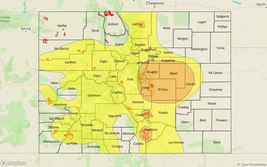
–A MODERATE flood threat is issued for portions of the Palmer Ridge, Front Range and Urban Corridor. This threat includes the Spring Creek, Junkins burn areas.
–A LOW flood threat is issued for portions of the Southwest Slope, San Juan Mountains, Grand Valley, Northwest Slope, Northern Mountains, Central Mountains, Southeast Mountains and Raton Ridge
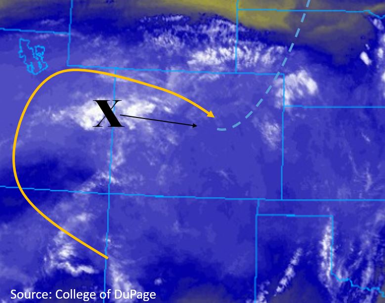
The strong upper level ridge remains overhead, with little to no changes in the upper level wind pattern since yesterday. Persistent flow of deep moisture on the backside of the high will provide high chances for thunderstorms throughout the state today. PW increased by approximately 0.25 inches at both Grand Junction and Denver from yesterday morning, measuring 1.28 inches and 0.98 inches respectively. Embedded within the flow is a shortwave and vorticity maximum (marked “X” below) that will make its way east throughout the day, providing strong forcing for thunderstorms. A weak surface low pressure system sits over the Southeast Plains this morning, which will delay normal upslope flow slightly and form a dryline over the eastern plains. Additionally, a cold front (blue line below) will move south over the eastern plains throughout the morning, producing thunderstorms over and south of the Palmer Ridge throughout the afternoon. Post frontal upslope flow will provide additional rainfall east of the Continental Divide later in the afternoon and into the early evening.
The primary area of concern today will be the recent burn areas within southern Front Range and Southeast Mountains. A weak thermal low is forecast to develop over northern New Mexico and the San Luis Valley, which will pull in high levels of moisture from the eastern plains. Moderate steering winds will allow multiple storms to slowly track over the recent burn areas and regions with near saturated soils. Over western Colorado steering flows will be much faster, reaching up to 30 mph, but deep atmospheric moisture and persistent storms will provide chances for flooding throughout the high country. Primary threats include: flash flooding of small streams and creeks, mud flows and debris slides. Storms are forecast to begin over the high country by noon and over the plains in the early afternoon with the passing cold front. Storms will end in a north to south fashion, between 12AM and 3AM.
Today’s Flood Threat Map
For more information on today’s flood threat, see the map below. For Zone-Specific forecasts, scroll below the map.

Zone-Specific Forecasts:
San Luis Valley, San Juan Mountains, Southwest Slope, Grand Valley, Northwest Slope, Central Mountains, Northern Mountains:
An incoming shortwave is forecast to move over the area this morning and be over central Colorado by midday. Thunderstorms are expected to form over the high country by noon and move to the southeast. Fast steering winds between 20 and 25 mph out of the northwest should prevent large accumulations over a 1 hour period, however persistent storms over a 2-3 hour period may provide chances for flooding. The heavier rain rates will favor the Central Mountains and San Juan Mountains, with max 2-3 hour rain rates of 1.75 and 1.25 inches respectively. Multiple storms tracking over the 416 burn area will provide chances of flooding, but fast winds confine the area to a Low flood threat. The Lake Christine and Weston Pass burn areas are also included with the Low flood threat area. Threats include flooding of small streams and creeks, flashing flooding, mud slides and debris flows.
Primetime: 12PM to 12AM
Front Range, Urban Corridor, Northeast Plains, Palmer Ridge, Southeast Plains, Southeast Mountains, Raton Ridge:
A Moderate flood threat returns today over southern Front Range, southern Urban Corridor, and the Palmer Ridge. A vorticity maximum is forecast to move over the area early this afternoon, providing lift to a moisture rich atmosphere for persistent moderate to severe thunderstorms. A cold front will make its way south over the eastern plains this morning and into the early afternoon, producing thunderstorms over and south of the Palmer Divide. Post frontal upslope flow over the eastern plains will provide additional lift over the Moderate threat area and create weak thunderstorms over the Northeast Plains. 2-3 hour rainfall rates up to 1.75 inches are forecast over the Moderate threat area. Recent precipitation has increased soil moisture over the area, which will increase the chance for flooding. Max 1 hour rainfall rates of 1.25 inches are forecast over the Southeast Plains, drier soils will reduce the chance for flooding.
A Moderate flood threat has been issued for the Spring Creek, and Junkins burn areas. Recent precipitation has created a surface environment that is primed for flooding. Persistent thunderstorms from the northwest will provide max 2-3 hour rainfall rates up to 1.8 inches over the Southeast Mountains. Threats over the burn areas include flash flooding of small creeks and streams, flooding over rural, mountain roadways, debris slides and mud flows. The threat for the Southeast Mountains extends until 3AM.
Primetime: 11AM to 3AM