Issue Date: Wednesday, July 24, 2019
Issue Time: 10:15AM MDT
— A MODERATE flood threat is issued for the 416 burn area
—A LOW flood threat is issued for portions of the San Juan Mountains, Southwest Slope, Grand Valley, Northwest Slope, Northern Mountains and Central Mountains. This threat includes the Lake Christine burn area.
The strong mid-level ridge that has controlled our weather for the past week remains the main weather feature today. Moisture continues to come into the area from the southwest, with PW measured at 1.04 inches at Grand Junction this morning. An incoming shortwave trough over the northern Great Plains will slowly weaken and push the ridge to the south today, transitioning upper level flow from southerly to westerly over western Colorado. This south-southwesterly flow of moisture (yellow line below) throughout the day and into tonight will generate consistent thunderstorms over the high country. Flow around the backside of a surface high pressure system over the Missouri River Valley will keep most of the eastern plains hot and dry today. A surface low, marked by an “L” below, is forecast to form over eastern Wyoming around noon, bringing in a cold front over the northeast plains later this afternoon. The frontal passage will provide a chance for thunderstorms over the northeast quadrant of the state.
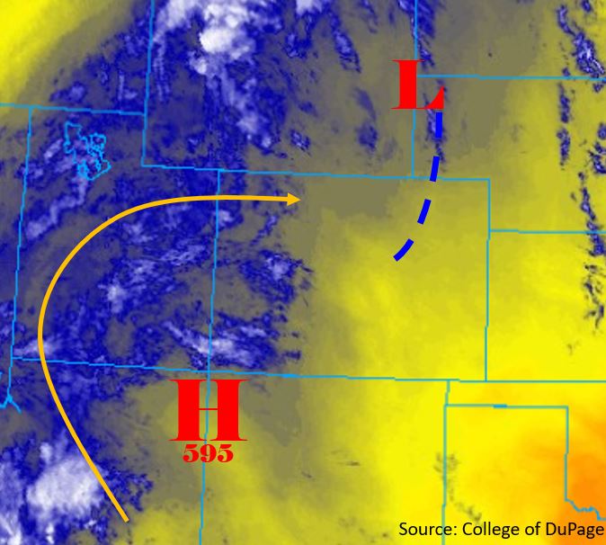
The primary concern for flooding today will be over the 416 burn scar, with chances for flooding over the western high country. Upper level convergence over the San Juan Mountains will cause storms to sit over the area for multiple hours. Persistent and slow moving storms over the burn scar could cause flooding this afternoon and into the evening. Surface dewpoints are forecast to remain in the upper 30°Fs to low 40°Fs to the west of the Continental Divide today, with high levels of PW present overhead. Storms will remain confined to the higher elevations due to upslope flow, with drier air in the valleys of the western slope. Sunny skies throughout the day will mix out moisture over the eastern plains, dropping dewpoints into the 40°Fs.
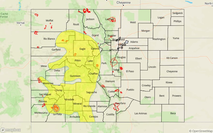
Today’s Flood Threat Map
For more information on today’s flood threat, see the map below. For Zone-Specific forecasts, scroll below the map.

Zone-Specific Forecasts:
Southwest Slope, Grand Valley, Northwest Slope, San Juan Mountains, Central Mountains, Northern Mountains, San Luis Valley, Southeast Mountains:
Moderate to high levels of moisture are expected over the forecast area today. Upper level forcing for severe thunderstorms is weak, however consistent moisture advection and upslope flow over the area will allow for persistent thunderstorms. A thermal low is forecast to form over the San Juan Mountains and San Luis Valley throughout the morning, allowing for strong convergence over the southwest. Persistent storms over the 416 burn area will allow for a max 2-3 hour rain rate up to 1.25 inches. Max 1-hour rain rates of 0.75 inches is forecast over the Low threat area. Thunderstorms are expected to begin around 1PM over the San Juan Mountains and Central Mountains, expanding in spatial area to encompass the entire forecast region by 3PM. Lower levels of moisture over the Southeast Mountains will limit max 3-hour rainfall rates to 0.5 inches over the recent burn areas. The threat over the 416 burn area and southern areas is expected to end by 11PM, with the threat ending in the northern areas by 3AM. Threats over the recent burn area include debris flows, mud slides and flash flooding.
Primetime: 1PM to 3AM
Front Range, Urban Corridor, Northeast Plains, Palmer Ridge, Southeast Plains, Raton Ridge:
Hot temperatures and ample sunshine is forecast to mix out moisture over the eastern plains throughout the day. Surface winds out of the south-southeast will bring in hot, dry air to form a dryline over the central eastern plains. Northerly steering flows and upper level inversions will keep thunderstorms capped over the Southeast Plains. A cold front coming in out of the north-northwest will provide chances for thunderstorms over the Northeast Plains around 5PM. Moisture from the west will combine with upslope flow over the Continental Divide to form thunderstorms over the Front Range by 2PM. Max 1-hour rain rates up to 0.4 inches is forecast over the high terrain. Convergence over the Palmer Ridge with the passing cold front will provide chances for thunderstorms over the area, with max 1-hour rain rates up to 0.6 inches. Storms are forecast to end by 10PM (west) and 2AM (east).
Primetime: 2PM to 2AM