Issue Date: Friday, August 23rd, 2019
Issue Time: 10:25AM MDT
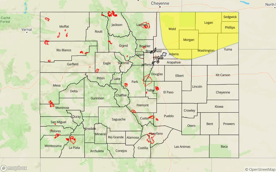
–A LOW flood threat has been issued for the Northeast and Southeast Plains
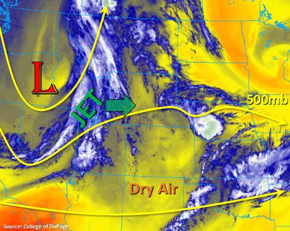
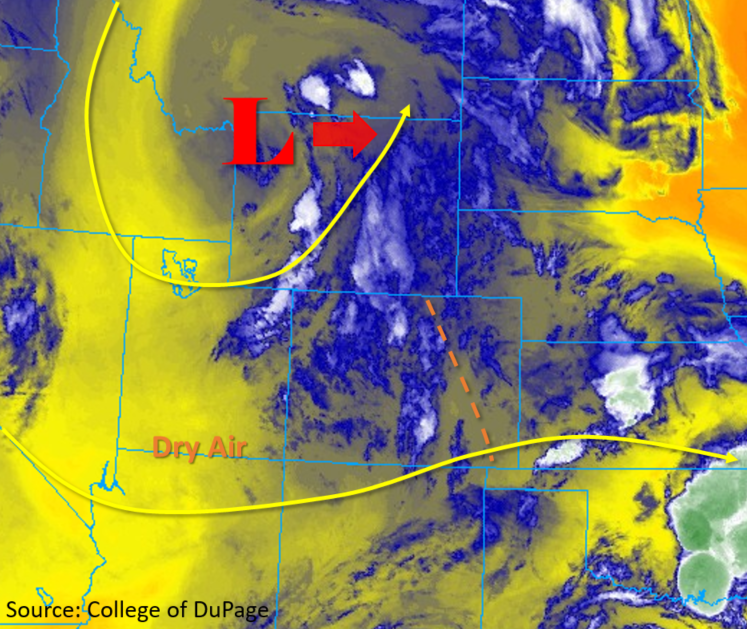
The upper level low marked in the water vapor imagery below will continue to move eastward today, which will provide enhanced dynamics over Colorado for stronger and more widespread thunderstorms this afternoon and evening. Some severe thunderstorms are forecast for the area in the Low flood threat with guidance indicating decent shear and CAPE over this area. Dew points over the eastern plains and Palmer Ridge are quite high, and with a surface low setting up over the eastern plains, southeasterly and easterly surface winds should keep this moisture in place over these regions. PW has decreased to 0.66 inches over Denver and will continue to drop with downsloping winds forecast today. The morning sounding has most of the moisture in the mid-levels, so cloud cover will be more likely than measurable rain as storms move off the mountains and into the adjacent plains this afternoon. Brief weak, thunderstorms are possible over the eastern high terrains this afternoon, but accumulation will be limited here as well.
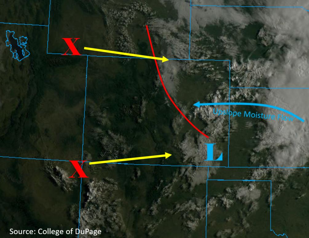
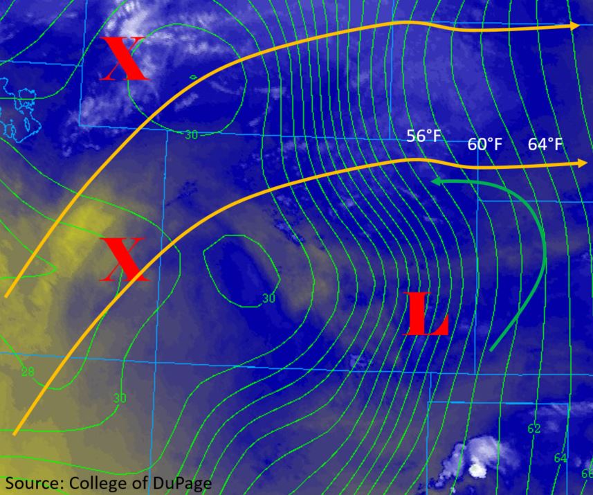
A tight moisture gradient is expected to develop over the eastern plains today with the aforementioned surface low and another surface low over eastern Wyoming. This westerly flow off of the eastern mountains will dry out the southern Urban Corridor, Raton Ridge and western Southeast Plains leaving little moisture for decent accumulations. Expect some gusty winds as the storms move through during the early afternoon hours. The current dryline (orange) is marked below, and PW is forecast to reach 1.6 inches on its eastern side, which will set the stage for some heavy rainfall accumulations for this evening and tonight.
Storm motion will be to the east today with the zonal upper level flow. Speed is forecast to initially be around 17-20 mph, but as storms move into the far east plains, expecting this to drop off a bit. Storms that move near Colorado’s eastern border (7-midnight) will be capable of producing flash flooding due to enhanced convergence over the area. Threats include road flooding, field ponding and flooding of low lying areas. Severe thunderstorms are also likely today with damaging winds (greater than 60 mph) as the main threat, although there will likely be moderate to large hail as well.
Back over western Colorado, dry air will still be in place while an even drier air mass moves in from Utah. Surface winds and low relative humidity will combine for another day of critical fire weather. A Red Flag Warning has been issued until 8PM tonight for the Northwest Slope. Slightly more moisture over the eastern San Juan Mountains may provide an increase in cloud cover, but don’t expect more than a few sprinkles.
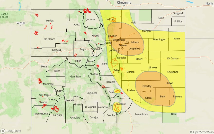
Today’s Flood Threat Map
For more information on today’s flood threat, see the map below. For Zone-Specific forecasts, scroll below the map.
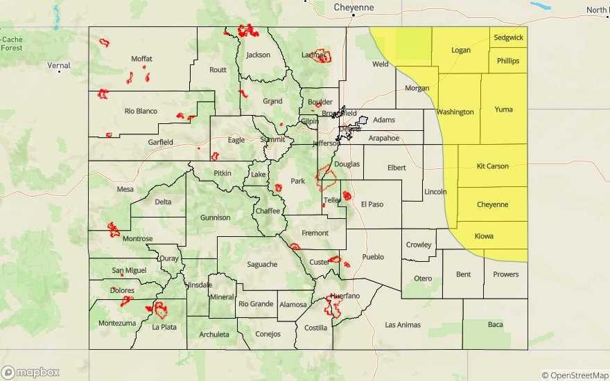

Zone-Specific Forecasts:
Northeast Plains, Palmer Ridge, Southeast Plains:
Max 1-hour rainfall rates up to 2 inches are possible near the CO/KS border with the severe thunderstorms that move into the area tonight. There is a chance for multiple storms tracking over the same area, so isolated totals around 3 inches by morning cannot be ruled out. To the north, 1-hour rain rates up will drop off to 1.75 inches. Large hail and damaging winds will also be possible with all the severe thunderstorms. A Low flood threat has been issued with threats including field ponding, road flooding, flooding of local streams and flooding of low lying areas. Downsloping flow should prevent storms over the western Southeast Plains, but a couple storms may form over Baca and Prowers Counties. Better moisture will be to the southeast, so max 1-hour rain rates will be limited to 1 inch.
Primetime: 7PM to Midnight
Front Range, Urban Corridor, Southeast Mountains, Raton Ridge:
Downsloping flow should prevent storms over the western Southeast Plains with the highest chance of measurable precipitation over the northern Front Range. Max 1-hour rain rates up to 0.3 inches will be possible over the eastern high terrains, but storms should be fairly isolated. If storms can form over the Teller County area, more moisture will allow the isolated storms to produce up to 0.7 inches. As storms move into the adjacent plains, 1 hour rain rates up to 0.5 inches will be possible east of I-25. Expect some gusty winds, but flooding is not expected.
Primetime: 1PM to 8PM
San Juan Mountains, San Luis Valley, Southwest Slope, Central Mountains, Grand Valley, Northwest Slope, Northern Mountains:
Red Flag Warning is in place for the northwest corner again today, so please use caution with any open flames. High temperatures will be similar to yesterday with some warming over the Northwest Slope and slight cooling over the San Juan Mountains. There may be a few clouds over the high terrains, but mostly clear skies are in order. Storms are possible over the eastern San Juan Mountains with the highest totals being isolated values of 0.15 inches.
Primetime: 1PM to 7PM