Issue Date: Wednesday, August 21st, 2019
Issue Time: 10AM MDT
—A MODERATE flood threat has been issued for the Front Range, Urban Corridor, Northeast Plains and Southeast Plains
—A LOW flood threat has been issued for the Palmer Ridge, Junkins burn area and Spring Creek burn area
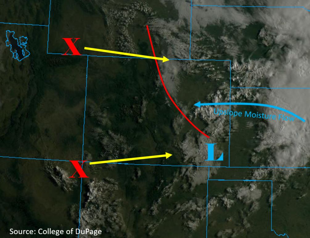
Widespread thunderstorms and heavy rainfall are forecast to the east of the Continental Divide today, and isolated storms will be possible again over the San Juan Mountains. The cold front that passed over the eastern plains last night has cooled down temperatures and created the cloud cover shown in the visible satellite imagery below. Expecting this to start to burn off throughout the day, which will build instability and set the stage for some severe thunderstorms and heavy rainfall this afternoon. Not surprising with all the cloud cover (indicates moisture return), dew points at Denver are in the upper 50°Fs with most areas over eastern Colorado currently showing 50°F+. PW at Denver jumped to 0.93 inches, which is in the 90th percentile for this time of year! A stationary front (red line below) has formed over the area and will be the primary focus for heavy rainfall tonight over the Southeast Plains.
Strong upslope flow to the north of the surface low, centered over the Southeast Plains, will provide moisture and lift for thunderstorm generation along the eastern mountains and Palmer Ridge. Additionally, two shortwaves (“X” below) are forecast to move across the state today, which will provide extra lift and increase storm coverage over the San Juan Mountains and Front Range/adjacent plains this afternoon. As the upper trough begins to move east off the Pacific Northwest coast today, the 500mb ridge access will slide east and upper flow (steering winds) will be from the northwest over eastern Colorado and more westerly over the western half of Colorado. This will allow upslope storms that form over the eastern mountains this afternoon to move into the adjacent plains. Easterly winds at the surface mean there will be some shear and decent CAPE where morning cloud cover can clear, so a couple severe thunderstorms are possible. Slow steering winds under the ridge will allow for some very heavy accumulations as storm motion will be to the southeast at 10-18 mph. Back building and trailing storms are also expected, which means the storms may linger over an area for more than an hour. As the storms move into the Southeast Plains, overnight heavy rainfall is also forecast along the stalled out boundary. Thus, this is an overnight threat.
Slight downsloping winds off the Southeast Mountains (due to the location of the surface low) will keep the highest moisture to the east. However, storms today will still be capable of producing 0.5 inches in an hour, so a Low flood threat has been issued for the Spring Creek burn area. Not thinking 1-hour rain rates will be high enough to cause any issues on the Junkins burn area. Though, totals in the area could reach 0.8 by tomorrow, so it is included it in the Low flood threat. Threats over burn areas include flash flooding of local creeks/streams, mud flows and debris slides. Severe storms today will be capable of producing large hail (quarter to up to half dollar) and strong winds from outflow boundaries. Flood threats include street flooding, local stream/creek/gulch flooding, flooding of low lying areas and field ponding. Arroyo flooding will be possible over the Southeast Plains.
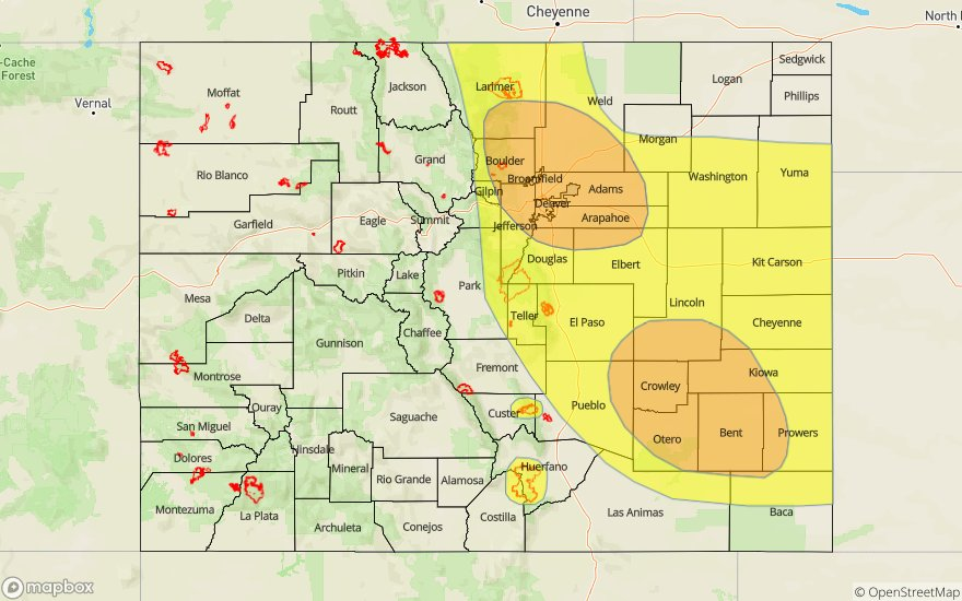
Today’s Flood Threat Map
For more information on today’s flood threat, see the map below. For Zone-Specific forecasts, scroll below the map.

Zone-Specific Forecasts:
San Juan Mountains, Southeast Mountains, Front Range, Urban Corridor, Palmer Ridge, Southeast Plains, Northeast Plains, Raton Ridge:
Storms are forecast to begin over the San Juan Mountains by 1PM with the eastern mountains following a couple hours later. Max 1-hour rainfall rates up to 0.4 inches are possible over the San Juans with rates increasing to 0.5 inches over the Southeast Mountains. Thus, a Low threat has been issued for the Spring Creek burn area where mud flows, debris slides and flash flooding will be possible if a storm tracks over the area. Storm totals near the Junkins burn area could reach 0.8 inches, so the Low threat has been extended to this area.
Over the Front Range foothills and Urban Corridor max 1-hour rainfall rates up 1.9 inches along with isolated storm totals up to 2.5 inches will be possible (totals more likely closer to 2.25 inches). Over the western Palmer Ridge, max 1-hour rain rates up to 1.1 inches will be possible. Guidance is also hinting at outflow boundaries possibility initiating additional storms over the Palmer Ridge and southern Northeast Plains, thus the Low threat has been extended to this area. Max 1-hr rain rates up to 1.25 inches will be possible over this area if storms break the cap. As the overnight rainfall sets up over the Southeast Plains and eastern Palmer Ridge, max 1-hour rain rates up to 2 inches are likely with storm totals just over 3 inches possible by morning. Flood threats include street flooding, local stream/creek/gulch flooding, flooding of low lying areas and field ponding. Arroyo flooding will be possible over the Southeast Plains. Please note this is an overnight threat. A Moderate flood threat has been issued.
Primetime: 1PM to 4AM
Southwest Slope, Grand Valley, San Luis Valley, Northwest Slope, Northern Mountains:
Moisture has not changed much since yesterday, so the chances of accumulations are slim to nil today. Brief, weak thunderstorms are possible this afternoon along and over the Continental Divide in the Central Mountains, and isolated accumulations up to 0.1 inches will be possible. Higher elevations over the Southwest Slope may also see some light accumulations, but totals are forecast to remain below 0.1 inches. The main threat will be gusty winds as storms fall apart and lightning. High temperatures may be a degree or two warmer, so be sure to stay hydrated once again. Expecting an increase in cloud cover overnight as the trough moves east, so overcast skies are forecast for tomorrow morning.
Primetime: 2PM to 8PM