Issue Date: Tuesday, August 20th, 2019
Issue Time: 10:50AM MDT
-A LOW flood threat has been issued for the Northeast Plains
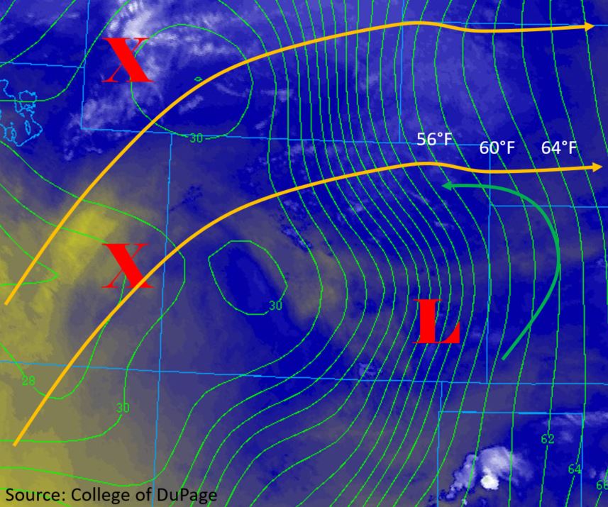
The threat of isolated severe thunderstorms will return to the Northeast Plains this afternoon and early this evening with the main hazards being large hail, damaging winds and local, heavy rainfall. Overall, not much change to the location of the 500mb high, but there are a few new features that are expected to set the stage for severe weather over the Northeast Plains. As noted in the FTO, two shortwaves (“X” below) are expected to move over and to the north of Colorado throughout the day from Utah and Wyoming. These features will provide lift to break the cap later this afternoon and create more widespread storms over this area. Marked on the water vapor imagery below is a low pressure system that has developed over the Southeast Plains. Clockwise, surface flow of moisture around the low (green arrow) will bring in dew points in the upper 60°Fs to the Northeast Plains, which will increase PW to ~1.4 inches over the area. This moisture should reach back to the eastern boundary of the Urban Corridor, which is quite a big moisture change from yesterday. Upslope flow along the Front Range and Palmer Ridge will also provide a chance for some afternoon thunderstorms over these higher terrains. Some storms may drift over the Urban Corridor, however dry air will limit the heavy rainfall threat.
Southwesterly and westerly flow of dry air aloft will continue west of the Continental Divide today, which will limit storm potential over most of the area. Southerly flow of mid-level moisture this morning over the eastern San Juan Mountains and Southeast Mountains will provide a chance for some afternoon high-based, weak thunderstorms, but rainfall accumulations are forecast to be minimal.
The threats for severe storms today over the Northeast Plains include heavy rainfall, wind gusts up to 70 mph and large hail (up to tennis ball size). Storms are expected to begin early to mid-afternoon over the eastern plains and continue until early tomorrow morning. Storm motion is forecast to be between 10 and 15 mph, which is slow enough to allow for heavy rainfall over a 1.5 to 2 hour period. A weak cold front dropping in from the north and a low level jet will be the forcing mechanisms (lift) for thunderstorms tonight. Rain rates may decrease at this time due to limited instability, but some high totals will still be possible by tomorrow morning. Drier air over the Southeast Plains will limit chances for rainfall though some isolated storms are possible near the Kansas border.
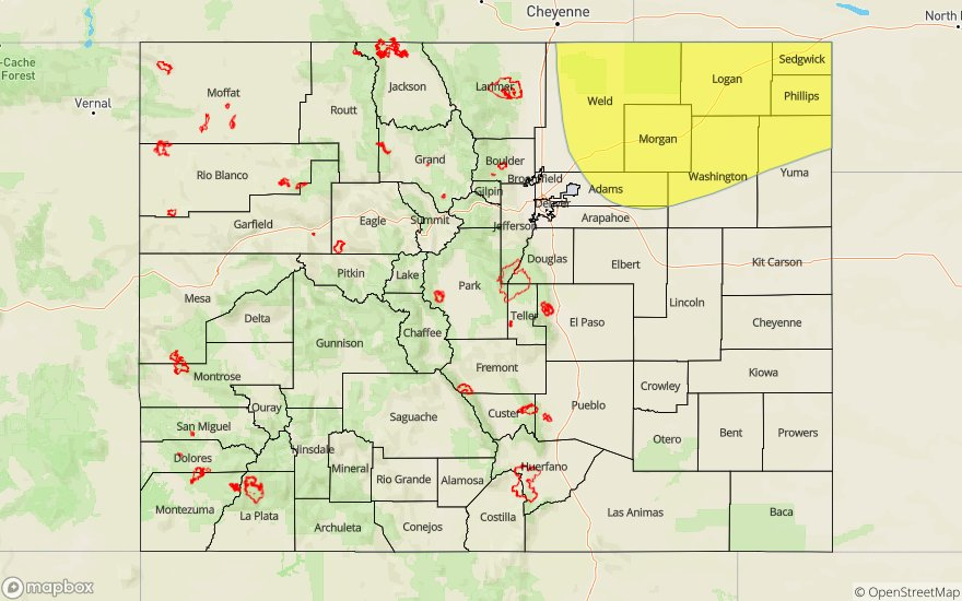
Today’s Flood Threat Map
For more information on today’s flood threat, see the map below. For Zone-Specific forecasts, scroll below the map.

Zone-Specific Forecasts:
Front Range, Urban Corridor, Northeast Plains, Palmer Ridge, Southeast Plains, Southeast Mountains, Raton Ridge:
The severe storms are forecast to begin mid-afternoon over the eastern plains favoring the eastern Palmer Ridge and Cheyenne Ridge for formation. Isolated max 1-hour rainfall rates up to 1.75 are possible with 1.5 to 2 hours totals up to 2.25 inches near the CO/NE border. Max 1-hour rainfall rates over the eastern Palmer Ridge are forecast to be just under 1 inch, so flooding is not expected. Downsloping flow over the Southeast Plains should keep storms isolated, but if they are able to break the cap near the Kansas border, totals up to 0.5 inches are possible. Storms that fire over the eastern mountains should produce only cloud cover and some brief gusty winds. Totals may increase to 0.15 inches if storms make it into the immediate adjacent plains and up to 0.6 inches over the Raton Ridge. Mostly expect another day of hot temperatures and broken records.
Primetime: 2PM to 4AM
San Luis Valley, San Juan Mountains, Southwest Slope, Grand Valley, Northwest Slope, Central Mountains, Northern Mountains:
Southerly flow of mid-level moisture this morning will provide a chance for afternoon thunderstorms over the eastern San Juan Mountains. However, dry air at the surface will mix out most of the moisture keeping max 1-hour rainfall rates around 0.15 inches. Some weak thunderstorms may be possible with the main threats being gusty winds and lightning. The rest of the forecast region is forecast to remain again today with a slight chance for isolated, weak thunderstorms along the Continental Divide. Afternoon high temperatures will be similar to yesterday, so be sure to keep hydrated.
Primetime: 2PM to 7PM