FTB 08-27-2019: Isolated, Weak Thunderstorms Forecast over the Raton Ridge & Northeast Plains

Issue Date: Tuesday, August 27th, 2019
Issue Time: 9:50AM MDT

Flooding is NOT expected today

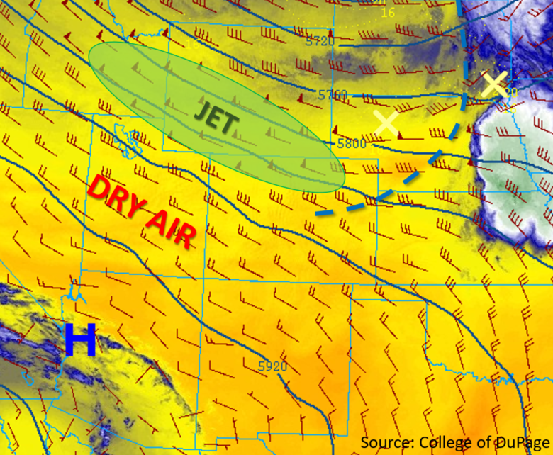
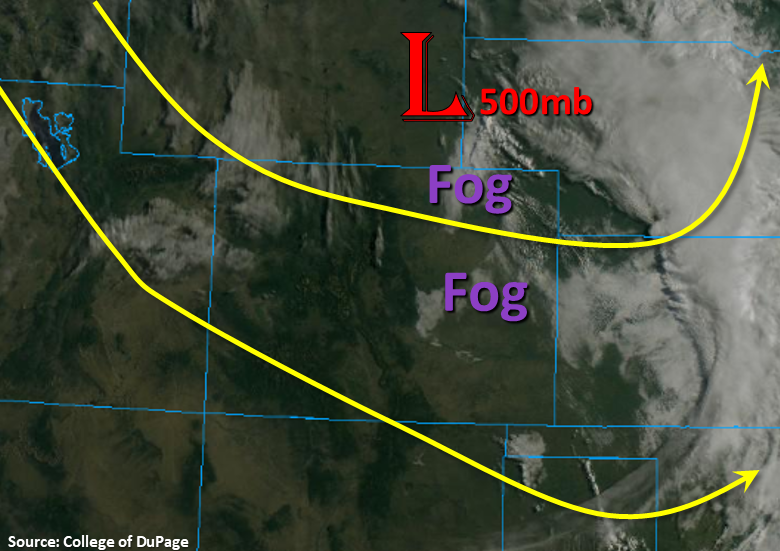
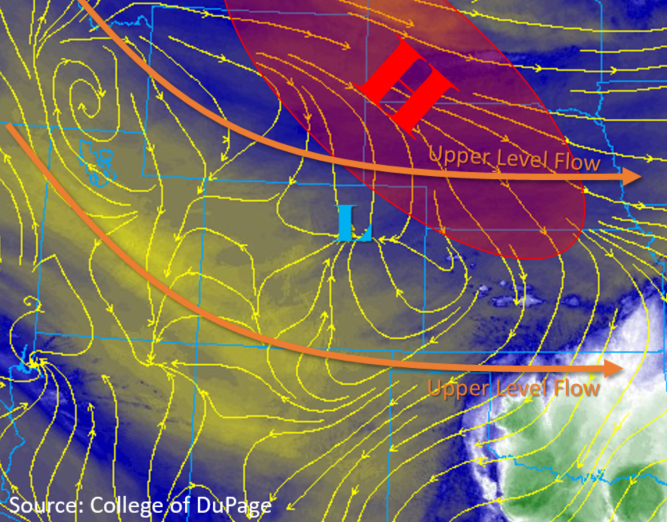
Dry weather is forecast again for most of the state today as a large dry arid mass continues to move its way in from the northwest flow aloft. PW over Grand Junction this morning was measured at 0.3 inches, which is just shy of the daily record low. This value may drop off slightly more, and the lack of moisture should prevent rainfall today over western Colorado. Moisture has somewhat returned to eastern Colorado with Denver’s PW measuring 0.71 inches this morning. Expecting the morning clouds and fog to clear out a bit with some daytime heating (minus the Northeast Plains), and overall looking at highs similar or slightly below yesterday’s high temperatures. The broad region of high pressure that ushered in cooler temperatures yesterday (marked H in the water vapor imagery below) will continue to expand and move east throughout the day. Clockwise flow around the high will bring in moderate levels of moisture to the eastern plains with easterly surface winds turning southerly over the plains.

Ongoing showers this morning over the Northeast Plains (generated by the weak surface low marked below) will likely intensify this afternoon as they move east. This is due to convergence along a cold front dropping south and mixing with the southerly winds generated by the surface high. Lift over the area should also be reinforced by a passing jet streak, so totals may be a little higher than they normally would be. Instability is on the lower end of the spectrum, due to the early nature of the storms, so rainfall rates are expected to remain below flood threat criteria.

Upslope flow is forecast to generate brief thunderstorms over the Raton Ridge and the western Palmer Ridge, similar to yesterday. Westerly upper level steering flows greater than 20mph and high-bases should keep accumulations low and help keep storms moving if they form over the Spring Creek burn area. Therefore, flooding is not forecast.


Today’s Flood Threat Map

For more information on today’s flood threat, see the map below. For Zone-Specific forecasts, scroll below the map.

Zone-Specific Forecasts:

Northeast Plains, Palmer Ridge, Front Range, Urban Corridor, Southeast Plains, Southeast Mountains, Raton Ridge:

Storms are forecast over the Northeast Plains, Raton Ridge and western Palmer Ridge today. Rain will begin mid-morning over the Northeast Plains with max 1-hour rainfall rates up to 0.85 inches possible this afternoon as storms intensify. A brief, isolated storm may be possible over the Colorado Springs area early this afternoon with max 1-hour rainfall rates up to 0.5 inches.  Lastly, the Raton Ridge is expecting another round of thunderstorms early this evening, but westerly surface flow should keep the storms off the Spring Creek burn area. Max 1-hour rainfall rates up to 0.9 inches are possible. Flooding is not forecast today.

Primetime: 9AM to 9PM

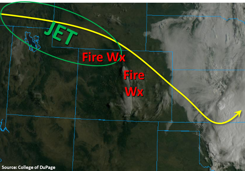
Northwest Slope, Northern Mountains, Grand Valley, Central Mountains, Southwest Slope, San Juan Mountains, San Luis Valley:

Near record low PW measurements over Grand Junction this morning will keep skies clear and precipitation chances near 0%. High temperatures should drop off another 3-5°F from yesterday with cooler air advecting in from the north. The reduction in wind speeds has brought the region out of critical fire weather, although there is still elevated fire danger due to the low relative humidity values. Some moderate gusts may be possible over the mountain valleys in the San Juan and Central Mountains, so continue to use caution with open flames.

FTB 08-26-2019: Cold Front Brings Temporary Relief from Hot Temperatures

Issue Date: Monday, August 26th, 2019
Issue Time: 9:30AM MDT

–Flooding is NOT expected today

The upper level trough that helped produce gusty winds and critical fire weather over the state yesterday is forecast to move slowly to our east throughout the day. This will decrease the coverage of critical fire danger, but areas of higher surface winds and low relative humidity are still expected to create pockets of enhanced fire weather over the mountain valleys and eastern plains this afternoon. At the surface, a cold front (blue dashed line below) is making its way south through the state this morning bringing wind gusts up to 38 mph (Pueblo) and a much cooler start to the morning. High pressure is forecast to build over the state behind the front, which will advect cool, stable air in from the north. These two features will increase stability and reduce high temperatures over eastern Colorado by as much as 10°F to 15°F. The majority of the state will remain rain free again today as dry air continues to move in from the northwest (orange and yellow colors in the water vapor imagery below). The best chance for measurable precipitation today will be over the Raton Ridge where the diurnal upslope flow and some residual moisture may produce a weak thunderstorm or shower. There is an isolated chance for another weak shower over the Palmer Ridge, but flooding is not forecast today.

Today’s Flood Threat Map

For more information on today’s flood threat, see the map below. For Zone-Specific forecasts, scroll below the map.

Zone-Specific Forecasts:

Northeast Plains, Palmer Ridge, Southeast Plains, Southeast Mountains, Raton Ridge:

High temperatures are forecast to drop by 10°F to 15°F as a cold front and dry air mass moves its way over the area this morning. A brief period of wind gusts up between 30 and 40 mph are possible as the front passes overhead. Surface winds will decrease this afternoon over the eastern plains to 10 – 18 mph, and with cooler temperatures, critical fire weather is not forecast at this time. There is a slight chance for showers late this afternoon over the Raton Ridge/Southeast Mountain intersect.  Max 1-hour rain rates up to 0.20 inches are possible.  Flooding is not forecast over the area.

Primetime: 5PM to 9PM

Northwest Slope, Northern Mountains, Front Range, Urban Corridor, Central Mountains, Grand Valley, Southwest Slope, San Juan Mountains, San Luis Valley:

Fire danger is forecast to decrease today as the jet stream moves to the east and a cooler air mass moves in. Isolated pockets of enhanced fire weather are still forecast over the Northern, Central and Front Range mountains where west and northwest winds in the valleys could reach between 20 and 25 mph. High temperatures will decrease by ~6°F to 10°F over the Northwest Slope/Northern Mountains and between 4°F and 6°F over the southern half of western Colorado. Measurable precipitation is not forecast today.

FTB 08-25-2019: Widespread Critical Fire Weather & Increasing Temperatures

Issue Date: Sunday, August 25th, 2019
Issue Time: 9AM MDT

— Flooding is NOT expected today

The main weather story today will be increasing temperatures and critical fire weather as a trough moves eastward to our north. This will tighten the pressure gradient and allow some strong winds to mix the surface. Over the last hour, a gust of 48mph was recorded at Berthoud Pass with a gust of 28mph recorded over Copper Mountain. PW has dropped off to 0.66 inches at Grand Junction (most moisture around 600mb) and 0.37 at Denver, which means the increasing surface winds and warm temperatures have caused a Red Flag Warning to be issued for the Northwest Slope and various locations over the high terrains from noon to 8PM. With abnormally high temperatures, relative humidity is expected to drop into the low teens this afternoon as well. As for rainfall, outside of a slight chance for a few drops near and along the Continental Divide over the Northern and eastern San Juan Mountains, it should be a rain free day. Flooding is not forecast.

Today’s Flood Threat Map

For more information on today’s flood threat, see the map below. For Zone-Specific forecasts, scroll below the map.

Zone-Specific Forecasts:

Front Range, Southeast Mountains, Northwest Slope, Grand Valley, Southwest Slope, Northern Mountains, Central Mountains, San Juan Mountains, San Luis Valley:

The Red Flag Warning will be the main weather event for today. Westerly surface winds are expected to be in the 15 to 25 mph range with gusts up to 40mph possible. We are already seeing higher gusts over the passes this morning, so be sure to stay alert when driving. These conditions will allow fires to start easily and spread rapidly, so use caution with open flames. High temperatures will climb close to 100°F over the lower elevations of western Colorado. Best chance for an isolated sprinkle is over the Northern or eastern San Juan Mountains along the Continental Divide. Flooding is not forecast.

Urban Corridor, Northeast Plains, Palmer Ridge, Raton Ridge, Southeast Plains:

Hot temperatures once again for the area with the thermometer nearing or exceeding over 100°F in isolated pockets over the lower elevations this afternoon. Some gusty winds are also likely along the I-25 corridor this afternoon. Rain is not in the forecast, and this morning’s fog over the eastern border should burn off rapidly with the dry air mass mixing out the remaining surface moisture.

FTB 08-24-2019: Dry Air and Subsidence Limits the Chances for Afternoon Storms

Issue Date: Saturday, August 24th, 2019
Issue Time: 9:10AM MDT

— Flooding is NOT expected today

The upper trough that helped support yesterday’s severe thunderstorms and Red Flag Warning is currently over the Nebraska/Wyoming border. Expecting this feature to continue to move southeast today and subsidence (sinking motion) to fill in behind it. The visible satellite imagery below shows some early morning fog over the eastern plains, but this should burn off with a little heating from the morning sun. There is also a disturbance noted over the Northwest corner below, which will move from northwest to southwest across the state today. Not expecting this feature to much more than provide some cloud cover from the heat, but it could help generate some light showers over the Southeast Mountains and the adjacent Southeast Plains/Raton Ridge later this afternoon and early evening.

The water vapor imagery (not shown) has some really dry air over the state, so not expecting much more than trace amounts of rainfall with storms today. There is slightly higher surface moisture along Colorado’s eastern border, so if storms pop in this area, expect light to moderate showers and an isolated, weak thunderstorm. A weak thunderstorms may be possible over the northeast corner as the low moves to the southeast, but flooding is not expected.

Today’s Flood Threat Map

For more information on today’s flood threat, see the map below. For Zone-Specific forecasts, scroll below the map.

Zone-Specific Forecasts:

Front Range, Urban Corridor, Northeast Plains, Palmer Ridge, Raton Ridge, Southeast Plains, Southeast Mountains:

Best chance for measurable rain this afternoon will be over the far Southeast/Northeast Plains and eastern Raton Ridge. With better moisture east, highest totals make sense here with only trace amounts forecast for the eastern Raton Ridge. Max 1-hour rain rates up to 0.75 inches will be possible over the far northeast corner with 0.5 inches possible over Baca and Prowers County. High temperatures are also expected to increase by 6-10°F this afternoon, so the heat is on the next couple of days. Flooding is not forecast.

Primetime: 3PM to 8:30PM

Northwest Slope, Grand Valley, Southwest Slope, Northern Mountains, Central Mountains, San Juan Mountains, San Luis Valley:

Wouldn’t be surprised if there is critical fire weather this afternoon somewhere over the Northwest Plains and some limited areas of the high terrains. For now, fire danger is just elevated with a higher threat tomorrow as northwest winds increase with a passing shortwave. Wind speeds in the mountains today could reach up to 20-25 mph with slightly lower speeds over the Northwest Slope. Not expecting any rainfall this afternoon except for maybe a drop or two over the eastern San Juan Mountains, which could track into the San Luis Valley with the northwest steering flows. Expect increasing cloud cover this afternoon and tonight as some mid-level energy moves north to south over the area, which will be nice as high temperatures are forecast to increase a couple degrees today.

Primetime: 3PM to 7PM