Issue Date: Saturday, August 24th, 2019
Issue Time: 9:10AM MDT
— Flooding is NOT expected today
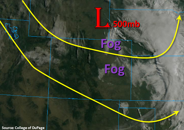
The upper trough that helped support yesterday’s severe thunderstorms and Red Flag Warning is currently over the Nebraska/Wyoming border. Expecting this feature to continue to move southeast today and subsidence (sinking motion) to fill in behind it. The visible satellite imagery below shows some early morning fog over the eastern plains, but this should burn off with a little heating from the morning sun. There is also a disturbance noted over the Northwest corner below, which will move from northwest to southwest across the state today. Not expecting this feature to much more than provide some cloud cover from the heat, but it could help generate some light showers over the Southeast Mountains and the adjacent Southeast Plains/Raton Ridge later this afternoon and early evening.
The water vapor imagery (not shown) has some really dry air over the state, so not expecting much more than trace amounts of rainfall with storms today. There is slightly higher surface moisture along Colorado’s eastern border, so if storms pop in this area, expect light to moderate showers and an isolated, weak thunderstorm. A weak thunderstorms may be possible over the northeast corner as the low moves to the southeast, but flooding is not expected.
Today’s Flood Threat Map
For more information on today’s flood threat, see the map below. For Zone-Specific forecasts, scroll below the map.
Zone-Specific Forecasts:
Front Range, Urban Corridor, Northeast Plains, Palmer Ridge, Raton Ridge, Southeast Plains, Southeast Mountains:
Best chance for measurable rain this afternoon will be over the far Southeast/Northeast Plains and eastern Raton Ridge. With better moisture east, highest totals make sense here with only trace amounts forecast for the eastern Raton Ridge. Max 1-hour rain rates up to 0.75 inches will be possible over the far northeast corner with 0.5 inches possible over Baca and Prowers County. High temperatures are also expected to increase by 6-10°F this afternoon, so the heat is on the next couple of days. Flooding is not forecast.
Primetime: 3PM to 8:30PM
Northwest Slope, Grand Valley, Southwest Slope, Northern Mountains, Central Mountains, San Juan Mountains, San Luis Valley:
Wouldn’t be surprised if there is critical fire weather this afternoon somewhere over the Northwest Plains and some limited areas of the high terrains. For now, fire danger is just elevated with a higher threat tomorrow as northwest winds increase with a passing shortwave. Wind speeds in the mountains today could reach up to 20-25 mph with slightly lower speeds over the Northwest Slope. Not expecting any rainfall this afternoon except for maybe a drop or two over the eastern San Juan Mountains, which could track into the San Luis Valley with the northwest steering flows. Expect increasing cloud cover this afternoon and tonight as some mid-level energy moves north to south over the area, which will be nice as high temperatures are forecast to increase a couple degrees today.
Primetime: 3PM to 7PM