Issue Date: Monday, August 26th, 2019
Issue Time: 9:30AM MDT
–Flooding is NOT expected today
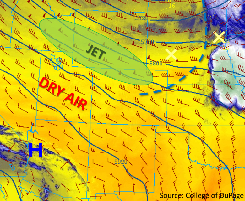
The upper level trough that helped produce gusty winds and critical fire weather over the state yesterday is forecast to move slowly to our east throughout the day. This will decrease the coverage of critical fire danger, but areas of higher surface winds and low relative humidity are still expected to create pockets of enhanced fire weather over the mountain valleys and eastern plains this afternoon. At the surface, a cold front (blue dashed line below) is making its way south through the state this morning bringing wind gusts up to 38 mph (Pueblo) and a much cooler start to the morning. High pressure is forecast to build over the state behind the front, which will advect cool, stable air in from the north. These two features will increase stability and reduce high temperatures over eastern Colorado by as much as 10°F to 15°F. The majority of the state will remain rain free again today as dry air continues to move in from the northwest (orange and yellow colors in the water vapor imagery below). The best chance for measurable precipitation today will be over the Raton Ridge where the diurnal upslope flow and some residual moisture may produce a weak thunderstorm or shower. There is an isolated chance for another weak shower over the Palmer Ridge, but flooding is not forecast today.
Today’s Flood Threat Map
For more information on today’s flood threat, see the map below. For Zone-Specific forecasts, scroll below the map.

Zone-Specific Forecasts:
Northeast Plains, Palmer Ridge, Southeast Plains, Southeast Mountains, Raton Ridge:
High temperatures are forecast to drop by 10°F to 15°F as a cold front and dry air mass moves its way over the area this morning. A brief period of wind gusts up between 30 and 40 mph are possible as the front passes overhead. Surface winds will decrease this afternoon over the eastern plains to 10 – 18 mph, and with cooler temperatures, critical fire weather is not forecast at this time. There is a slight chance for showers late this afternoon over the Raton Ridge/Southeast Mountain intersect. Max 1-hour rain rates up to 0.20 inches are possible. Flooding is not forecast over the area.
Primetime: 5PM to 9PM
Northwest Slope, Northern Mountains, Front Range, Urban Corridor, Central Mountains, Grand Valley, Southwest Slope, San Juan Mountains, San Luis Valley:
Fire danger is forecast to decrease today as the jet stream moves to the east and a cooler air mass moves in. Isolated pockets of enhanced fire weather are still forecast over the Northern, Central and Front Range mountains where west and northwest winds in the valleys could reach between 20 and 25 mph. High temperatures will decrease by ~6°F to 10°F over the Northwest Slope/Northern Mountains and between 4°F and 6°F over the southern half of western Colorado. Measurable precipitation is not forecast today.