FTB 09-24-2019: Slight Increase in Temperatures and Another Dry Day Ahead

Issue Date: Tuesday, September 24th, 2019
Issue Time: 9:10AM MDT

— Flooding is NOT expected today

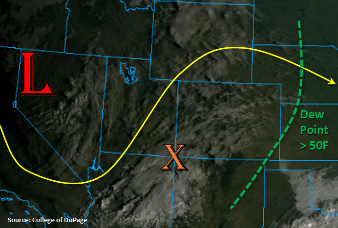
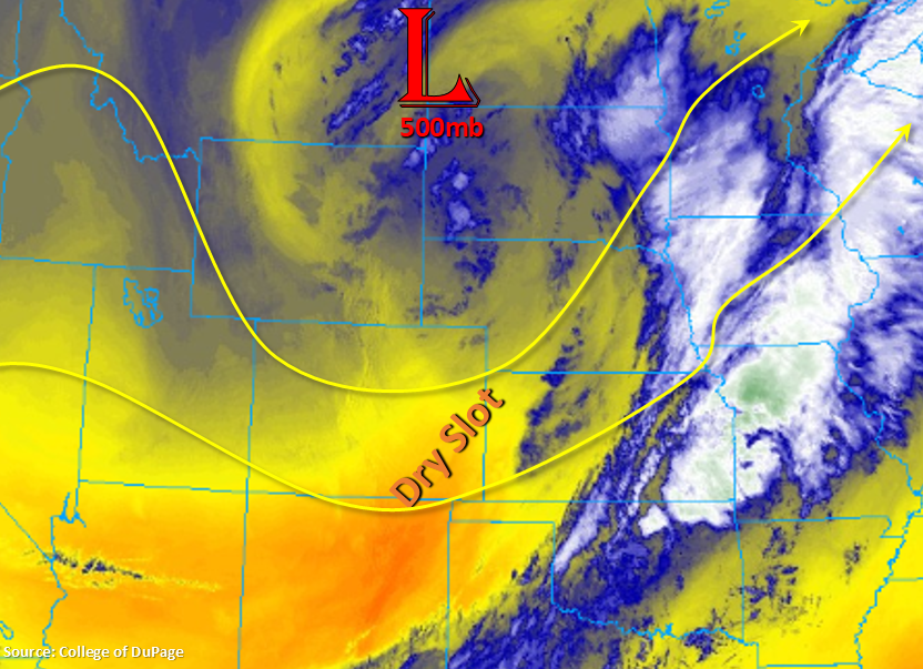
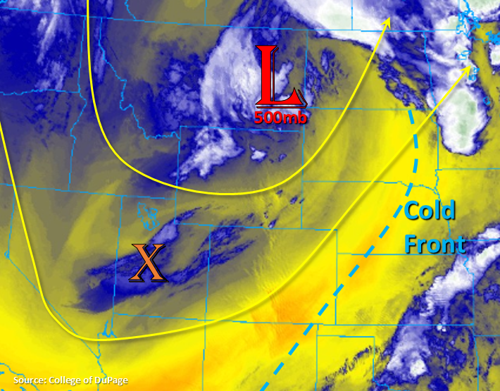
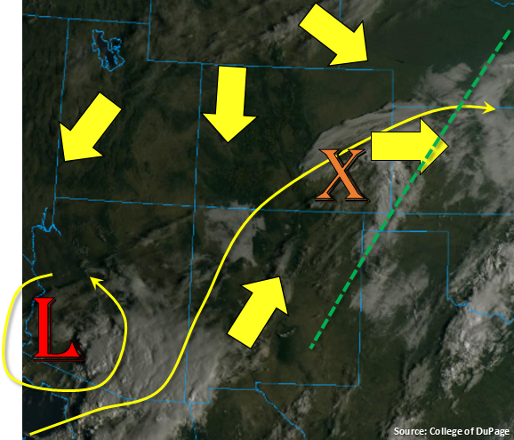
Marked in the visible satellite imagery below is mid-level energy (orange “X”), which is helping produce some cloud cover over the eastern plains and southern Urban Corridor. Not much moisture in the low levels, so this is mostly mid-level cloud cover. This should begin to burn off throughout the morning and move eastward with the upper flow. The yellow arrows below are showing the upper level steering flow direction (various strengths) with the state between two systems. There is one system to the north with the jet moving towards Colorado’s northern border throughout the day. This will drop a very weak cold front though the plains, which will translate to a change in direction of the surface winds to more northerly. Then there is the cut off low to our southwest, which is marked below. The southwest flow from AZ/NM around this low will likely pull in high cloud cover again to the southern tier of the state, which will start west and then move east. A dry air mass, especially at the lower levels, remains over the state with the best moisture for afternoon storms east of the green line below and to our southwest. This translates to another rain-free day with temperatures also rising a 5°F to 10°F. Flooding is not forecast.

Today’s Flood Threat Map

For more information on today’s flood threat, see the map below. For Zone-Specific forecasts, scroll below the map.

Zone-Specific Forecasts:

San Juan Mountains, Southeast Mountains, Southwest Slope, San Luis Valley, Raton Ridge, Southeast Plains:

Expecting afternoon and early evening cloud cover once again with mid-level energy rotating around the cut off low. This will be similar to yesterday with mid to high level clouds. It’s also a bit drier in the low levels, so not thinking there will be any rainfall. Temperatures will rise a few degrees this afternoon when compared to yesterday. Clearing skies will allow low temperatures to drop off tonight, but freezing temperatures are only expected for the highest terrains.

Front Range, Urban Corridor, Palmer Ridge, Northeast Plains, Central Mountains, Northern Mountains, Northwest Slope, Grand Valley:

Rainfall is not forecast for these areas due to the dry air mass overhead, upper level temperature inversions (capped) and subsidence in the right exit region of the jet streak (northeast corner). Temperatures will increase 5°F to 10°F when compared to yesterday despite northerly surface winds. Overnight lows will drop into the 50°Fs (lower elevations) with mid-30°Fs for most of the mountains regions.

FTB 09-23-2019: Cool Morning to Start Fall with Mostly Dry Conditions Forecast

Issue Date: Monday, September 23rd, 2019
Issue Time: 9:10AM MDT

— Flooding is NOT expected today

Fall officially began early this morning, and cooler morning temperatures certainly made it feel more seasonable. Lows dipped into the 30°Fs over the northwest corner (lower elevations) and San Luis Valley again with Denver bottoming out at 48°F. Highs should rebound quite a bit today with a building ridge and drier air mass overhead. There’s some morning cloud cover over the state associated with some energy moving through the southwest flow aloft. Expect this cloud cover to continue on and off today with only clear skies forecast for the far southeast corner. The upper low over Nevada will dig south throughout the day and be cut off from the main flow by early tomorrow morning. This feature is forecast to sit south and west of the state, which should keep a drier air mass in place for the majority of the state. Thus, rainfall is not anticipated for the northern 2/3 of the state.

Over the southern 1/3 of the state, moisture associated with the mid-level energy below (orange “X”) is forecast to move in, so some isolated showers and weak thunderstorms will be possible over the southern Southwest Slope and San Juan Mountains this afternoon. This vorticity max will move eastward this evening, so storms are expected to spread into the San Luis Valley and maybe even the Southeast Mountains by morning. With instability dwindling after sundown, rain rates will really start to drop off, so the accumulating rainfall might not make it all the way east. A light dusting of snow may also be possible for the highest elevations of the eastern San Juan Mountains.

Today’s Flood Threat Map

For more information on today’s flood threat, see the map below. For Zone-Specific forecasts, scroll below the map.

Zone-Specific Forecasts:

San Juan Mountains, Southeast Mountains, Southwest Slope, San Luis Valley:

Best chance for rain this afternoon and evening will be over southern tiers of these regions. Highest totals are forecast for the eastern San Juan Mountains and eastern Southwest Slope due to a bit more instability and moisture available during the afternoon. Max 1-hour rain rates up to 0.2 inches will be possible with most totals below this threshold. Some light showers may also occur over the San Luis Valley as this feature moves east, but totals should remain under 0.1 inches with more mist and cloud cover than measurable rainfall. Can’t rule out a light dusting of snow over the highest elevations of the San Juan Mountains later tonight, but large accumulations are not expected. Low temperatures should also be warmer, so freezing temperatures should be avoided in the San Luis Valley.

Primetime: 2PM to 4AM

Front Range, Urban Corridor, Raton Ridge, Palmer Ridge, Southeast Plains, Northeast Plains:

Highs this afternoon will rebound into the 80°Fs with some upper 80°Fs over the Southeast Plains where skies remain clear. The drier air mass overhead and inversions in the upper atmosphere will prevent accumulating rainfall, though on and off cloud cover can be expected with the shortwave. The 50°F dew point line in the visible satellite imagery above is to the east of the area, which is usually a good marker for rainfall chances. Should be a beautiful day with calm winds except over the far Southeast Plains where some breezy southerly surface winds are expected (15 to 20 mph).

Central Mountains, Northern Mountains, Northwest Slope, Grand Valley:

These areas should remain rain-free as well with dry air in place and a building ridge. Highs will barely reach 80°F over Grand Junction with 70°Fs forecast for the other valleys. Still a little warm for this time of year, but appreciated after the late hot streak. Lows should be about 5°F warmer than last night, so not thinking any Freeze Watches will need to be issued for the lower elevations.

FTB 09-22-2019: Rain-Free Day & More Seasonable Temperatures for the Last Day of Summer

Issue Date: Sunday, September 22nd, 2019
Issue Time: 8:20AM MDT

— Flooding is NOT expected today

The vertically stacked trough is over the North Dakota/Montana border this morning, and the well-defined cold front is to our east. This puts the state in the dry slot of the trough with PW at Denver and Grand Junction measured at 0.48 and 0.32 inches, respectively. This is helping produce clear conditions this morning along with very cool, and some places cold, temperatures. Subsidence is forecast with the ridge axis sliding east, and without much moisture, it should be clear skies this afternoon across the state. An approaching trough to our west will increase cloud cover this evening and overnight along the western border into the high terrains, but rainfall is not forecast.

Today’s Flood Threat Map

For more information on today’s flood threat, see the map below. For Zone-Specific forecasts, scroll below the map.

Zone-Specific Forecasts:

Front Range, Southeast Mountains, Urban Corridor, Raton Ridge, Palmer Ridge, Southeast Plains, Northeast Plains:

The small amount of lingering rainfall and cloud cover over the Northeast Plains should mix out and move east over the next hour or so. Forecasting cooler high temperatures today with the lower elevations in the upper 70°Fs to low 80°Fs, and the mountains in the 60°Fs. Only light surface (variable in direction) surface winds are forecast, so fire danger will decrease as well.

Central Mountains, Northern Mountains, San Juan Mountains, Northwest Slope, Grand Valley, Southwest Slope, San Luis Valley:

Similar high temperatures both east and west today. Forecasting the lower elevations to reach the upper 70°Fs with the mountains in the 60°Fs. The San Luis Valley likely hit the freezing mark overnight with freezing temperatures also being reported over the northwest corner. Despite the anticipated evening cloud cover (acts as a blanket), temperatures will still be low, but freezing may be avoided in some of the lower elevations. Currently, there are no Freezing Watches or Warning issued for tonight, but this may change. To keep track of these alerts, please follow NWS Grand Junction.

FTB 09-21-2019: Cool & Dry Until the Next Shortwave Arrives this Evening

Issue Date: Saturday, September 21st, 2019
Issue Time: 8:45AM MDT

— Flooding is NOT expected today

The trough that affected yesterday’s weather is now over Montana and behind the trough, a cold front dropped through the state overnight. Therefore, it is a cooler start to the morning over the majority of the state, especially the northwest corner where isolated areas reached freezing temperatures. Not much moisture associated with the frontal passage as PW was measured at 0.41 over Denver and 0.32 inches over Grand Junction (dry slot). This and a 600mb cap (Denver) should keep post frontal upslope flow from producing any rainfall this afternoon. Expecting PW to increase from west to east later this afternoon and evening as the dry slot (behind the cold front) moves eastward and another shortwave moves through with additional moisture.

Marked over Utah is the shortwave that will arrive this evening. Some mid-level energy broke off two larger troughs merging to our north, so this will help give the trough more of a positive tilt going forward (weaken the strength). A stronger cold front will slide into the state around 6PM tonight. Temperatures will really drop off overnight with sub-freezing temperatures forecast for the San Luis Valley (below 8,500 feet). A Freeze Watch has been issued for this area. With moisture increasing from the approaching trough, expecting showers and weak thunderstorms this evening over eastern Colorado with post frontal upslope flow and the mid-level energy overhead. Measurable rainfall will most likely occur over the Northeast Plains and Palmer Ridge, but some weak showers may be possible along the CO/KS border as well. Flooding is not forecast.

Today’s Flood Threat Map

For more information on today’s flood threat, see the map below. For Zone-Specific forecasts, scroll below the map.

Zone-Specific Forecasts:

Front Range, Southeast Mountains, Urban Corridor, Raton Ridge, Palmer Ridge, Southeast Plains, Northeast Plains:

With these regions in the dry slot this afternoon and stronger upper level winds still in the area, there may be pockets of elevated fire danger this afternoon. Not thinking surface winds speeds (10-15 knots) will be strong enough to reach Red Flag Warning criteria, but worth mentioning due to the dry vegetation. High temperatures will cool off a few degrees from yesterday with sunny skies forecast this afternoon. An approaching trough and cold front this evening will increase the chances for weak, overnight showers and thunderstorms over the Northeast Plains and Palmer Ridge. Isolated totals up to 0.5 inches will be possible by morning with most totals closer to 0.15 to 0.25 inches. Flooding is not forecast.

Primetime: 5PM to 6AM

Central Mountains, Northern Mountains, San Juan Mountains, Northwest Slope, Grand Valley, Southwest Slope, San Luis Valley:

Should be a mostly clear day with more seasonable temperatures, although highs will still be a couple degrees warmer than average further south. The approaching trough and associated cold front is expected to increase cloud cover over the northwest corner by mid-afternoon with overnight cloud cover forecast for the Northern and Central Mountains. This may help keep temperatures above freezing, but please follow NWS Grand Junction for the latest on Freeze Warnings. Cold overnight temperatures are forecast for the San Luis Valley, so a Freeze Watch is in place for elevations below 8,500 feet. With dry, cool air, rainfall is not forecast. The ridge begins to move/build overhead by Sunday, so looking a break from rainfall, hot temperatures and fire weather through Monday.