Issue Date: Saturday, September 21st, 2019
Issue Time: 8:45AM MDT
— Flooding is NOT expected today
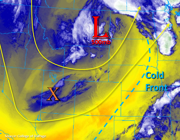
The trough that affected yesterday’s weather is now over Montana and behind the trough, a cold front dropped through the state overnight. Therefore, it is a cooler start to the morning over the majority of the state, especially the northwest corner where isolated areas reached freezing temperatures. Not much moisture associated with the frontal passage as PW was measured at 0.41 over Denver and 0.32 inches over Grand Junction (dry slot). This and a 600mb cap (Denver) should keep post frontal upslope flow from producing any rainfall this afternoon. Expecting PW to increase from west to east later this afternoon and evening as the dry slot (behind the cold front) moves eastward and another shortwave moves through with additional moisture.
Marked over Utah is the shortwave that will arrive this evening. Some mid-level energy broke off two larger troughs merging to our north, so this will help give the trough more of a positive tilt going forward (weaken the strength). A stronger cold front will slide into the state around 6PM tonight. Temperatures will really drop off overnight with sub-freezing temperatures forecast for the San Luis Valley (below 8,500 feet). A Freeze Watch has been issued for this area. With moisture increasing from the approaching trough, expecting showers and weak thunderstorms this evening over eastern Colorado with post frontal upslope flow and the mid-level energy overhead. Measurable rainfall will most likely occur over the Northeast Plains and Palmer Ridge, but some weak showers may be possible along the CO/KS border as well. Flooding is not forecast.
Today’s Flood Threat Map
For more information on today’s flood threat, see the map below. For Zone-Specific forecasts, scroll below the map.
Zone-Specific Forecasts:
Front Range, Southeast Mountains, Urban Corridor, Raton Ridge, Palmer Ridge, Southeast Plains, Northeast Plains:
With these regions in the dry slot this afternoon and stronger upper level winds still in the area, there may be pockets of elevated fire danger this afternoon. Not thinking surface winds speeds (10-15 knots) will be strong enough to reach Red Flag Warning criteria, but worth mentioning due to the dry vegetation. High temperatures will cool off a few degrees from yesterday with sunny skies forecast this afternoon. An approaching trough and cold front this evening will increase the chances for weak, overnight showers and thunderstorms over the Northeast Plains and Palmer Ridge. Isolated totals up to 0.5 inches will be possible by morning with most totals closer to 0.15 to 0.25 inches. Flooding is not forecast.
Primetime: 5PM to 6AM
Central Mountains, Northern Mountains, San Juan Mountains, Northwest Slope, Grand Valley, Southwest Slope, San Luis Valley:
Should be a mostly clear day with more seasonable temperatures, although highs will still be a couple degrees warmer than average further south. The approaching trough and associated cold front is expected to increase cloud cover over the northwest corner by mid-afternoon with overnight cloud cover forecast for the Northern and Central Mountains. This may help keep temperatures above freezing, but please follow NWS Grand Junction for the latest on Freeze Warnings. Cold overnight temperatures are forecast for the San Luis Valley, so a Freeze Watch is in place for elevations below 8,500 feet. With dry, cool air, rainfall is not forecast. The ridge begins to move/build overhead by Sunday, so looking a break from rainfall, hot temperatures and fire weather through Monday.