Issue Date: Sunday, September 22nd, 2019
Issue Time: 8:20AM MDT
— Flooding is NOT expected today
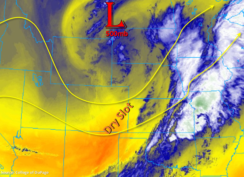
The vertically stacked trough is over the North Dakota/Montana border this morning, and the well-defined cold front is to our east. This puts the state in the dry slot of the trough with PW at Denver and Grand Junction measured at 0.48 and 0.32 inches, respectively. This is helping produce clear conditions this morning along with very cool, and some places cold, temperatures. Subsidence is forecast with the ridge axis sliding east, and without much moisture, it should be clear skies this afternoon across the state. An approaching trough to our west will increase cloud cover this evening and overnight along the western border into the high terrains, but rainfall is not forecast.
Today’s Flood Threat Map
For more information on today’s flood threat, see the map below. For Zone-Specific forecasts, scroll below the map.
Zone-Specific Forecasts:
Front Range, Southeast Mountains, Urban Corridor, Raton Ridge, Palmer Ridge, Southeast Plains, Northeast Plains:
The small amount of lingering rainfall and cloud cover over the Northeast Plains should mix out and move east over the next hour or so. Forecasting cooler high temperatures today with the lower elevations in the upper 70°Fs to low 80°Fs, and the mountains in the 60°Fs. Only light surface (variable in direction) surface winds are forecast, so fire danger will decrease as well.
Central Mountains, Northern Mountains, San Juan Mountains, Northwest Slope, Grand Valley, Southwest Slope, San Luis Valley:
Similar high temperatures both east and west today. Forecasting the lower elevations to reach the upper 70°Fs with the mountains in the 60°Fs. The San Luis Valley likely hit the freezing mark overnight with freezing temperatures also being reported over the northwest corner. Despite the anticipated evening cloud cover (acts as a blanket), temperatures will still be low, but freezing may be avoided in some of the lower elevations. Currently, there are no Freezing Watches or Warning issued for tonight, but this may change. To keep track of these alerts, please follow NWS Grand Junction.