FTB 09-28-2019: Windy and Mainly Dry

Issue Date: 9/28/2019
Issue Time: 7:16 AM

NO FLOOD THREAT IS FORECAST TODAY.

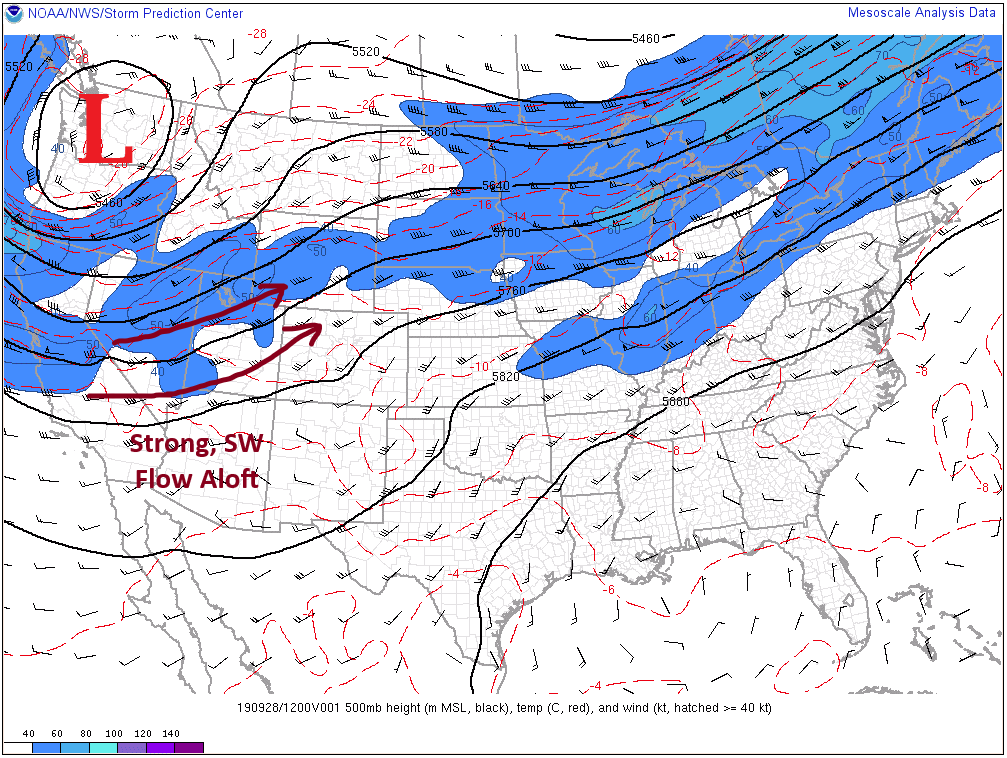
If you take a look at the upper-air analysis below, you will notice the main features for today’s forecast. The upper-level low, marked by the red “L,” is in the process of deepening along the west coast, and in response, strong, southwesterly flow aloft (maroon arrows) has settled in across the Central and Northern Rockies. This strong, southwesterly flow will serve two purposes today: 1) it will allow for the development of a couple isolated, high-based showers over the High Country, and 2) it will lead to very gusty winds over the High Country.

East of the mountains, a strengthening surface low over eastern Wyoming will bring gusty, southerly winds to the area. The breezy conditions will allow temperatures to warm to pleasant levels, with highs in the 70s/80s for most of eastern Colorado, with a few locations remaining in the mid-to-upper 60s over the Palmer Ridge and in the far Northeast Plains where a bit of cloud cover this morning will hinder full daytime heating.

Today’s Flood Threat Map

For more information on today’s flood threat, see the map below. For Zone-Specific forecasts, jump below the map.

Flood Threat Legend

Zone-Specific Forecasts

Front Range, Southeast Mountains, Urban Corridor, Northeast Plains, Southeast Plains, Palmer Ridge, and Raton Ridge:

Breezy conditions will be the most noticeable impact today, with wind gusts up to 35-45 mph in the Front Range and Southeast Mountains and 25-35 mph over the lower elevations. An isolated shower over the Front Range is possible during the afternoon/evening, but little-to-no rainfall is expected.

Northern Mountains, Northwest Slope, Central Mountains, Grand Valley, Southwest Slope, San Juan Mountains, and San Luis Valley:

Gusty winds will be the main weather story today, with wind gusts of 25-40 mph over the Southwest Slope and San Juan Mountains, 35-45 mph in the San Luis Valley, and 40-55 mph over the Northern Mountains, Northwest Slope, Grand Valley, and Central Mountains regions. Gusts up to 60 mph will be possible at the highest peaks north of I-70. A few isolated, high-based showers will develop during the afternoon/evening hours, with one or two continuing into the early morning. Little-to-no rainfall is expected.

FTB 09-27-2019: The Next Trough Begins to Dig South and Returns Rainfall Chances to Northern Colorado

Issue Date: Friday, September 27th, 2019
Issue Time: 9:25AM MDT

— Flooding is NOT expected today

Taking a look at the water vapor imagery below there are a couple of things happening today. First the cut off low, which is now an open wave, finally starts to move eastward and will be located over southern New Mexico by tonight. It’s a little bit too far south to push much mid-level energy or extra PW into the state, but it should help enhance storm coverage over the eastern San Juan Mountains this afternoon by providing a slight increase in moisture. Westerly flow aloft will scour out most of the moisture over the San Luis Valley, Southeast Mountains and adjacent eastern plains, but a weak shower or two be possible over the mountains with the main threat being wind due to the large spread in temperature and dew point.

To our north, the next trough starts to dig south over the west coast, which will push a shortwave into the state, which is currently over the Utah/Idaho border (orange “X” with arrow). As the next trough has been digging south, there has been a slight increase in moisture (that will continue) over the northern portion of the state. Denver measured 0.64 inches in this morning’s sounding, which is up 0.10 inches from this time yesterday. The shortwave is expected to help spark more widespread coverage of showers and weak thunderstorms over the Front Range and Northern Mountains this afternoon. The jet also began to move into northern Colorado this morning, so this will similarly help fuel storms this afternoon and will likely support weak showers over the high terrains near the Divide tonight. With fast westerly steering flows aloft, expecting the storms to push into the adjacent plains by late this afternoon. With low dew points (upper 30°Fs to 40°Fs), despite a cold front that pushed through overnight, gusty outflow winds will be the main threat from storms today with only moderate to light rainfall forecast. Flooding is not expected from storms today due to the fast storm motion and lack of low level moisture.

Today’s Flood Threat Map

For more information on today’s flood threat, see the map below. For Zone-Specific forecasts, scroll below the map.

Zone-Specific Forecasts:

Front Range, Urban Corridor, Palmer Ridge, Northern Mountains, Northeast Plains:

Fast storm motion and lack of low level moisture will keep storms at moderate to light rainfall accumulations with scattered coverage. Storms will fire a little later this afternoon, so they are expected to spread into the adjacent plains around 4PM. Max 1-hour rain rates up to 0.4 inches are possible with 24-hour totals up to 0.5 inches possible along the northern Continental Divide and northern Weld County. Most storms will produce rain rates at or below 0.25 inches favoring the Palmer Ridge and southern Cheyenne Ridge over the adjacent plains. A few lingering showers will be possible over the high terrains this evening, but flooding is not forecast. The main threats from today’s storms will be gusty outflow winds with the jet overhead. This is especially true over the Northern Mountains and Front Range where gusts could reach 40-45 mph.

Primetime: 3PM to 4AM

San Juan Mountains, Northwest Slope, Grand Valley, Central Mountains, Southwest Slope, San Luis Valley, Southeast Mountains, Raton Ridge, Southeast Plains:

Storms today will be confined to the high terrains, although the increased cloud cover at the lower elevations may produce some light sprinkles for western Colorado. Slight increase in moisture over the eastern San Juan Mountains and north Central Mountains from the open wave and approaching trough. Max 1-hour rain rates up to 0.5 inches (south) and 0.3 inches (north) will be possible favoring the western facing slopes. Westerly wind will scour out most of the moisture east of the Divide, so only a few showers will be possible over the Southeast Mountains, again favoring the west facing slopes. Flooding is not forecast for storms today, and all activity should end a few hours after sundown.

Primetime: 2:30PM to 11PM

FTB 09-26-2019: Late Afternoon and Evening Scattered Storms Return to the Western Mountains

Issue Date: Thursday, September 26th, 2019
Issue Time: 9:20AM MDT

— Flooding is NOT expected today

The cut off low that has been sitting over southern CA/AZ becomes an open wave today as the next trough starts to dig south over the Pacific Northwest. This will release some mid-level energy and push slightly higher PW values northward. So forecasting isolated to scattered showers to return to the Central and San Juan Mountains later this afternoon and evening. Over Grand Junction, PW increases 0.3 inches to put it around 0.7 inches by late this afternoon. While this moisture return will allow for light accumulation (high-based storms), back building storms could help slightly increase totals. The high-based storms are also expected to produce some gusty outflow winds. Rainfall may continue overnight in the Central Mountains and along the Continental Divide as a cold front starts to drop south. Additionally, Critical Fire weather returns to the Northwest Slope and Northern Mountains this afternoon as moisture won’t reach that far north. The increase in winds is due to the tightening gradient from the approaching trough. Southwest surface winds in the 20 to 30 mph range with gusts between 40 and 50 mph can be expected. A Red Flag Warning has been issued from noon to 8PM tonight.

There is a slight moisture return for eastern Colorado as well, so this may allow a weak shower or two to form over the southern Front Range/Palmer Ridge this afternoon. Rather than wetting rainfall, the more likely scenario is just an increase in cloud cover due to the lack of moisture and fast storm motion to the east. Elevated fire danger is expected over the northern Front Range, which includes the foothills and mountain valleys. Flooding is not forecast for Thursday.

Today’s Flood Threat Map

For more information on today’s flood threat, see the map below. For Zone-Specific forecasts, scroll below the map.

Zone-Specific Forecasts:

San Juan Mountains, Northern Mountains, Northwest Slope, Grand Valley, Central Mountains, Southwest Slope, San Luis Valley:

Best chance for rainfall accumulation will be over the higher terrains of the San Juan and Central Mountains favoring the southwest facing slopes. Storms will likely produce gusty outflow winds as well. Max 1-hour rain rates up to 0.5 inches will be possible over the San Juan Mountains with max 1-hour rates decreasing to 0.25 inches over the Central Mountains. Very isolated storm totals up to 0.7 inches will be possible over the San Juans with up to 0.5 inches possible over the Central Mountains. Due to the later nature of the rainfall (decrease in instability = gradual rainfall), flooding is not forecast.

Primetime: 4PM to 11PM

Front Range, Urban Corridor, Palmer Ridge, Northeast Plains, Southeast Mountains, Raton Ridge, Southeast Plain:

Best chance for an isolated afternoon storms will be over the Front Range and Palmer Ridge. With fast westerly steering flows, and only minimal increases in low level moisture, max storm totals should remain under 0.1 inches. Virga may allow for some brief, gusty outflow winds. Strong surface winds can be expected over the Northern Front Range with gusts up to 50 mph possible with the tightening pressure gradient. Flooding is not forecast.

Primetime: 4PM to 9PM

FTB 09-25-2019: Warm and Dry Statewide

Issue Date: Wednesday, September 25th, 2019
Issue Time: 9:05AM MDT

— Flooding is NOT expected today

Not much change in the forecast when compared to yesterday. Colorado remains sandwiched between the same two weather systems, which will keep the dry air overhead another day. Visible satellite was showing a little fog over eastern Prowers/Baca Counties earlier this morning, but it has likely mixed out by now. Another rainless day is forecast with temperatures slightly cooler than yesterday, but still above average for late September. There will likely be an increase in cloud cover this afternoon, and a weak cold front is forecast to move through the eastern plains overnight as a trough moves eastward to our north. This may bring some morning cloud cover and light rainfall/mist to the eastern plains tomorrow morning. Be sure to get out and enjoy the nice weather as rain will return to the forecast as the cut off low begins to lift north and east tomorrow.

Today’s Flood Threat Map

For more information on today’s flood threat, see the map below. For Zone-Specific forecasts, scroll below the map.

Zone-Specific Forecasts:

San Juan Mountains, Northern Mountains, Northwest Slope, Grand Valley, Central Mountains, Southwest Slope, San Luis Valley:

High temperatures will be similar to yesterday an increase in cloud cover expected again this afternoon. Dew points in the mid to upper 20°Fs and 30°Fs means it is too dry for any rainfall this afternoon. Surface winds will be weak, so there is no fire danger. Some stronger winds (15-20 mph) may be possible over the Northern Mountains, so there may be some patches of enhanced fire weather with the dry vegetation. Flooding is not forecast.

Front Range, Urban Corridor, Palmer Ridge, Northeast Plains, Southeast Mountains, Raton Ridge, Southeast Plain:

Another rain free day with temperatures slightly cooler than yesterday thanks to a weak cold front that moved south earlier this morning. Not expecting post frontal rainfall from upslope flow due to the dry air overhead, but an increase in cloud cover will be likely. Some stronger surface winds may also be possible over the northern Front Range with the jet moving through northeast Colorado today. Overnight, another cold front moves through the eastern plains, so morning cloud cover may be possible with some light rainfall/mist over the eastern plains.