Issue Date: Wednesday, September 25th, 2019
Issue Time: 9:05AM MDT
— Flooding is NOT expected today
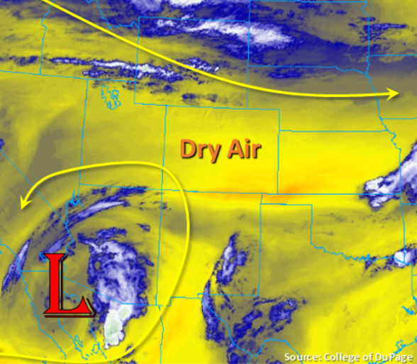
Not much change in the forecast when compared to yesterday. Colorado remains sandwiched between the same two weather systems, which will keep the dry air overhead another day. Visible satellite was showing a little fog over eastern Prowers/Baca Counties earlier this morning, but it has likely mixed out by now. Another rainless day is forecast with temperatures slightly cooler than yesterday, but still above average for late September. There will likely be an increase in cloud cover this afternoon, and a weak cold front is forecast to move through the eastern plains overnight as a trough moves eastward to our north. This may bring some morning cloud cover and light rainfall/mist to the eastern plains tomorrow morning. Be sure to get out and enjoy the nice weather as rain will return to the forecast as the cut off low begins to lift north and east tomorrow.
Today’s Flood Threat Map
For more information on today’s flood threat, see the map below. For Zone-Specific forecasts, scroll below the map.
Zone-Specific Forecasts:
San Juan Mountains, Northern Mountains, Northwest Slope, Grand Valley, Central Mountains, Southwest Slope, San Luis Valley:
High temperatures will be similar to yesterday an increase in cloud cover expected again this afternoon. Dew points in the mid to upper 20°Fs and 30°Fs means it is too dry for any rainfall this afternoon. Surface winds will be weak, so there is no fire danger. Some stronger winds (15-20 mph) may be possible over the Northern Mountains, so there may be some patches of enhanced fire weather with the dry vegetation. Flooding is not forecast.
Front Range, Urban Corridor, Palmer Ridge, Northeast Plains, Southeast Mountains, Raton Ridge, Southeast Plain:
Another rain free day with temperatures slightly cooler than yesterday thanks to a weak cold front that moved south earlier this morning. Not expecting post frontal rainfall from upslope flow due to the dry air overhead, but an increase in cloud cover will be likely. Some stronger surface winds may also be possible over the northern Front Range with the jet moving through northeast Colorado today. Overnight, another cold front moves through the eastern plains, so morning cloud cover may be possible with some light rainfall/mist over the eastern plains.