FTB 06-06-2020: Flash Flood and Fire Threats to Start the Weekend

Issue Date: 6/6/2020
Issue Time: 9:50 AM

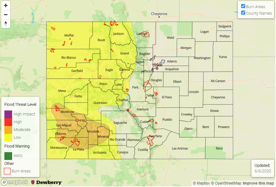
— A MODERATE Flood Threat is Forecast Today for Portions of the Southwest Slope, San Juan Mountains, including the 416 Fire Burn Area

— A LOW Flood Threat is Forecast Today for Portions of the Southwest Slope, San Juan Mountains, Grand Valley, Northwest Slope, Northern Mountains, and Central Mountains Regions, including the Lake Christine Fire Burn Area

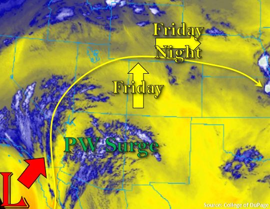
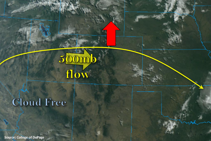
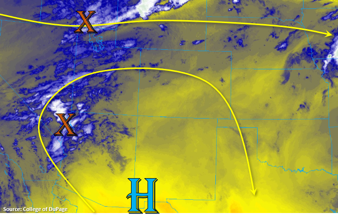
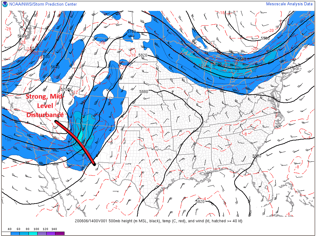
The mid-level low-pressure system that came onshore the Southern California coast yesterday will shift northeastward today, crossing directly over Colorado as it makes its way towards eastern Montana/western North Dakota. The dynamic support that this type of system brings, combined with sufficient moisture, will allow for organized thunderstorms to develop late this morning/early this afternoon over western Colorado, which will quickly race to the east-northeast with the disturbance. Severe wind gusts, hail, isolated tornadoes, and bouts with moderate-to-heavy rainfall are expected from the strongest of these storms.

The 416 Fire burn area and the Lake Christine Fire burn area are within today’s flood threat areas, and they deserve close attention. Storm motions and the scattered nature of storms will mitigate the risk of flash flooding, so they do not merit more than the larger flood threat assigned to their region. However, due to their quick-reacting nature, any strong storm can be a problem.

Early in the afternoon, the wave of strong storms will reach the easternmost mountains, eventually pushing over the plains by mid-to-late afternoon. A few will be strong-to-severe, producing wind gusts up to 80 mph, large hail, and plenty of cloud-to-ground lightning. Aside from the storm threat today, high winds and dry conditions are expected, and Red Flag and High Wind Warnings have been issued. Please refer to your local National Weather Service office for more information regarding these warnings.

Today’s Flood Threat Map

For more information on today’s flood threat, see the map below. Hover over the threat areas for more details and click on burn areas to learn more about them. For Zone-Specific forecasts, scroll below the threat map.

Zone-Specific Forecasts

Front Range, Southeast Mountains, Urban Corridor, Palmer Ridge, Northeast Plains, Southeast Plains, and Raton Ridge:

A wide range of weather impacts are possible today, beginning with this morning’s scattered showers and thunderstorms, Red Flag and High Wind warnings thanks to the large-scale conditions aided by the mid-level low pressure system, and a bout with strong-to-severe thunderstorms this afternoon and evening. The highest risk of severe weather will be over the mountains and high valleys, where wind gusts up to 80-100 mph, large hail, and isolated tornadoes will be possible with the strongest storms. East of the mountains, surface wind gusts will be strong in the absence of thunderstorms, and underneath thunderstorms, wind gusts may reach up to 80 mph. No flash flood threat is warranted, as storm motions will be too quick to the east-northeast for rain rates generally around 0.2-0.4 inches/hour to cause flash flooding. However, the strongest storms may produce rain rates up to 0.5-0.7 inches/hour, which may cause localized street/field ponding.

Primetime: 11 AM – 7 PM for the Front Range and Southeast Mountains; Noon – 9 PM for the Urban Corridor, Palmer Ridge, and Raton Ridge; 2 PM – 11 PM for the Northeast Plains and Southeast Plains.

Northwest Slope, Northern Mountains, Grand Valley, Central Mountains, Southwest Slope, San Juan Mountains, and San Luis Valley:

Scattered showers and weak thunderstorms this morning are the opening act for strong-to-severe thunderstorms later this morning through this afternoon. Due to the increase in available moisture, a low-to-moderate flood threat has been issued for much of western Colorado (see threat map above). Quick storm motions to the east-northeast will mitigate the flood threat somewhat, but steep terrain, burn scars, and frequent problem areas will need to be monitored. The strongest storms may produce wind gusts up to 60-80 mph in the valleys, and up to 100 mph at the highest elevations, along with frequent lightning, large hail up to 1.5” in diameter, and isolated tornadoes.

Timing: 10 AM – 3 PM for the Southwest Slope, San Juan Mountains, Grand Valley regions, 10 AM – 5 PM for the Northwest Slope, Northern Mountains, Central Mountains, and San Luis Valley

FTB 06-05-2020: Transitioning Pattern Brings Rainfall to Western Colorado

Issue Date: Friday, June 5th, 2020
Issue Time: 8:55AM MDT

— Flooding is NOT expected today

It’s finally time for the highly anticipated rainfall event to begin over western and central Colorado. The Low that has been spinning off the coast of California will start to move inland today. Initially, flow aloft over the state will be westerly as the ridge builds northward. Residual moisture is expected to spark a few diurnally driven storms over the eastern higher terrains this afternoon, which will spread into the adjacent plains with the westerly steering flow. There should be less moisture than yesterday in the lower-levels, so storms aren’t expected to make it into the eastern plains. They will also quickly become outflow driven and may produce some gusty winds. Only light rainfall and virga are forecast.

Back to the west, the northward PW surge begins with the moisture marked in the image below. This moisture should reach the southern border by late afternoon/early evening, which will start the first wave of rainfall around 6PM. Note, that as the Low moves into Arizona tonight, the axis of the ridge will be pushed eastward, and in turn, flow aloft will turn more southerly. This will result in storm motion being SSW to NNE tonight and tomorrow morning. The more southerly flow will also push some mid-level energy through western and central Colorado with that initial PW surge, which will aid in overnight shower activity along with diffluence aloft. There should be a break in rainfall before the next wave of energy arrives at the southern border by early tomorrow morning. This will trigger another round of rain beginning around 6AM. Therefore, ongoing showers are expected tomorrow morning before the FTB comes out, but flooding is not expected. Rain rates are expected to become more efficient by tomorrow as the first round of storms will help moisten the boundary layer, PW increases (nears the early June record), and instability is on the upswing with a little daytime heating.

Today’s Flood Threat Map

For more information on today’s flood threat, see the map below. If there is a threat, hover over the threat areas for more details, and click on burn areas to learn more about them. For Zone-Specific forecasts, scroll below the threat map.

Zone-Specific Forecasts:

Central Mountains, San Juan Mountains, Northern Mountains, Northwest Slope, Grand Valley, & Southwest Slope:

Trailing/stationary storms and widespread coverage of evening and overnight rainfall will help increase morning totals for these regions. Isolated max 1-hour rain rates up to 0.25 inches will be possible if a couple stronger storms can form, but most max 1-hour rain rates will remain between 0.10-0.15 inches. Isolated 24-hour totals up to 0.50 inches over the higher terrains of the Northwest Slope, Grand Valley and Southwest Slope are possible by morning. Flooding is not forecast as rain rates remain well below flood threat criteria (including burn areas).

Before the PW surge reaches the Grand Valley, Southwest Slope and Northwest Slope, dry conditions and increasing surface winds with the tightening pressure gradient are expected to produce critical fire conditions this afternoon. This means conditions will be favorable for the rapid ignition, growth and spread of fires. So, a Red Flag Warning has been issued from noon to 8PM this evening. Please check in with NWS Grand Junction for more information.

Primetime: 5PM to 8AM

Front Range, Southeast Mountains, Raton Ridge, Palmer Ridge, Urban Corridor, Southeast Plains, Northeast Plains, & San Luis Valley:

Best chances for storms will be over the southern Front Range and Palmer Ridge with only a handful of storms forecast for the Southeast Mountains and northern Front Range. A couple storms may also form over the western portions of the Palmer Ridge and Raton Ridge. Storms will likely dissipate as quickly as they pop, which could cause some brief, strong winds again. Those outflow winds are not expected to be as widespread as yesterday as guidance suggests decreasing storm activity. Max 1-hour rain rates up to 0.15 inches will be possible, but most storms will produce plenty of virga and only a couple of sprinkles.

Primetime: 2:30PM to 9PM

FTB 06-04-2020: Summer Temperatures with Limited Rainfall

Issue Date: Thursday, June 4th, 2020
Issue Time: 9:15AM MDT

— Flooding is NOT expected today

Beautiful start to the morning with a few clouds over the state. There are some clouds lingering over the Southeast Plains from overnight convection, but these should clear up rather quickly with the daytime heating. The Northwest Slope also has cloud cover, which is associated with ripples moving through the zonal flow to our north. Expecting the ridge shown below to build northwards today (red arrow), which means another round of hot afternoon temperatures. Flow aloft will turn more westerly as this happens, which will continue to pull in the dry air mass from our west and southwest. This will mix out a good majority of the remaining surface moisture trapped under the ridge.

The result – a continued downturn in afternoon convection as dew points drop. Westerly flow across the state will place the dry line well into Kansas/Nebraska, so severe storms over the eastern plains are not probable this afternoon. High-based storms are still anticipated to form over the mountains with upslope flow, and the best chance for a little rainfall will be over the Northern, Central and northern Front Range Mountains near the Divide. Additional scattered storms will likely form over the elevated regions of the Palmer and Raton Ridges. Once again, the main threat from storms will be brief, gusty winds. This is especially true as storms move off the mountains, with the westerly flow, and become outflow driven. As anticipated, flooding is not forecast.

Today’s Flood Threat Map

For more information on today’s flood threat, see the map below. If there is a threat, hover over the threat areas for more details, and click on burn areas to learn more about them. For Zone-Specific forecasts, scroll below the threat map.

Zone-Specific Forecasts:

Front Range, Southeast Mountains, Northern Mountains, Central Mountains, Raton Ridge, Palmer Ridge, Urban Corridor, Southeast Plains, Northeast Plains, & San Luis Valley:

Best chances for storms will be over the northern high terrains with higher accumulations (west) along the Divide. Max 1-hour rain rates up to 0.20 inches will be possible. Storms over the adjacent plains may produce pockets of totals up to 0.25 inches, but many storms will just provide cloud cover from the heat and a couple sprinkles. Flooding is not forecast, and storms are expected to decrease in coverage a couple hours after the sun sets.

Primetime: 2:30PM to 9:30PM

San Juan Mountains, Northwest Slope, Grand Valley, & Southwest Slope:

A couple storms may fire over the elevated areas of these regions this afternoon with best coverage further north where lift and moisture is a little better. For the most part, cumulus will produce virga and brief, windy conditions. Rainfall amounts should remain well below 0.10 inches. Hot temperatures are forecast once again with a slight increase from yesterday.

Primetime: 1:30PM to 8PM

FTB 06-03-2020: Drying Trend Continues with High-Based, Afternoon Thunderstorms Forecast

Issue Date: Wednesday, June 3rd, 2020
Issue Time: 9:45AM MDT

— Flooding is NOT expected today

Below is the low-level water vapor imagery, and it’s noteworthy that not much moisture looks be trapped under the ridge over the state. This is indicated by more yellow than blue/white. Westerly flow aloft continues over the majority of the state today as the ridge builds northward, which will help further mix out low-level moisture and help set up a dryline (area of convergence) over the far eastern plains. There is also some mid-level energy noted in the image below (orange “X”). One is to our north, and the other further south. The one to our north may help spark some additional thunderstorms over the Cheyenne Ridge that will likely spill into the Northeast Plains with the clockwise steering winds around the High, and it will help set up the dryline over the Northeast Plains. The other shortwave further south may help spark better thunderstorm coverage over the eastern San Juan Mountains and Southeast Mountains/Raton Ridge than there would otherwise be with the diurnal flow pattern. Storms that form over the mountains and Palmer/Raton ridges will move westward with the steering flow.

Coverage of storms will decrease this afternoon due to the increased dryness, and storms that do form are expected to be high-based with the lower dew points. The large difference in temperature and dew points (dew point depression) means gusty outflow winds will be the main threat from storms. Slightly faster steering flows will also limit the amount of rainfall over an area. Higher accumulations are expected further west along the dryline that sets up, but only moderate rainfall is anticipated. Therefore, flooding is not expected today.

Today’s Flood Threat Map

For more information on today’s flood threat, see the map below. If there is a threat, hover over the threat areas for more details, and click on burn areas to learn more about them. For Zone-Specific forecasts, scroll below the threat map.

Zone-Specific Forecasts:

Front Range, Southeast Mountains, San Juan Mountains, Raton Ridge, Palmer Ridge, Southeast Plains, Urban Corridor, & Northeast Plains:

Over the mountains, storms will favor areas south and east of the Continental Divide. Additionally, storms are anticipated to form over the southern Front Range Mountains, Palmer Ridge and Raton Ridge. Activity will likely spill into the adjacent plains with the westward motion. Max 1-hour rain rates up to 0.25 inches will be possible under the stronger storms with gusty outflow winds being the main threat from storms this afternoon and evening.

There will likely be a couple areas of rainfall over the Northeast Plains as storms this afternoon initially form along a moisture boundary. Max 1-hour rain rates up to 0.75 inches will be possible over Phillips, Yuma, and Kit Carson County along with severe hail. Then, additional storms may be possible in the region as storms that form north rotate south around the high. Max 1-hour rain rates for those storms will drop to 0.50 inches. Mid-level energy may bring some lighter rainfall to the Southeast Plains this evening, and totals should remain under 0.25 inches.

Primetime: 1PM to 11PM

Central Mountains, San Luis Valley, Northern Mountains, Northwest Slope, Grand Valley, & Southwest Slope:

A bit too dry for widespread coverage of afternoon storms, but the passing shortwave to the north may provide a little extra moisture to the northern border. Inverted-V sounds indicated strong outflow winds will be possible with storms that do fire over the Northern Mountains, northern Central Mountains, and Northwest Slope this afternoon. Elsewhere it’s going remain dry and hot with high temperatures similar to yesterday.

Primetime: 1PM to 9PM