Issue Date: Friday, June 5th, 2020
Issue Time: 8:55AM MDT
— Flooding is NOT expected today
It’s finally time for the highly anticipated rainfall event to begin over western and central Colorado. The Low that has been spinning off the coast of California will start to move inland today. Initially, flow aloft over the state will be westerly as the ridge builds northward. Residual moisture is expected to spark a few diurnally driven storms over the eastern higher terrains this afternoon, which will spread into the adjacent plains with the westerly steering flow. There should be less moisture than yesterday in the lower-levels, so storms aren’t expected to make it into the eastern plains. They will also quickly become outflow driven and may produce some gusty winds. Only light rainfall and virga are forecast.
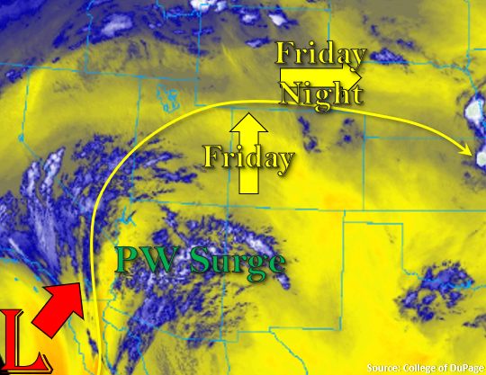
Back to the west, the northward PW surge begins with the moisture marked in the image below. This moisture should reach the southern border by late afternoon/early evening, which will start the first wave of rainfall around 6PM. Note, that as the Low moves into Arizona tonight, the axis of the ridge will be pushed eastward, and in turn, flow aloft will turn more southerly. This will result in storm motion being SSW to NNE tonight and tomorrow morning. The more southerly flow will also push some mid-level energy through western and central Colorado with that initial PW surge, which will aid in overnight shower activity along with diffluence aloft. There should be a break in rainfall before the next wave of energy arrives at the southern border by early tomorrow morning. This will trigger another round of rain beginning around 6AM. Therefore, ongoing showers are expected tomorrow morning before the FTB comes out, but flooding is not expected. Rain rates are expected to become more efficient by tomorrow as the first round of storms will help moisten the boundary layer, PW increases (nears the early June record), and instability is on the upswing with a little daytime heating.
Today’s Flood Threat Map
For more information on today’s flood threat, see the map below. If there is a threat, hover over the threat areas for more details, and click on burn areas to learn more about them. For Zone-Specific forecasts, scroll below the threat map.

Zone-Specific Forecasts:
Central Mountains, San Juan Mountains, Northern Mountains, Northwest Slope, Grand Valley, & Southwest Slope:
Trailing/stationary storms and widespread coverage of evening and overnight rainfall will help increase morning totals for these regions. Isolated max 1-hour rain rates up to 0.25 inches will be possible if a couple stronger storms can form, but most max 1-hour rain rates will remain between 0.10-0.15 inches. Isolated 24-hour totals up to 0.50 inches over the higher terrains of the Northwest Slope, Grand Valley and Southwest Slope are possible by morning. Flooding is not forecast as rain rates remain well below flood threat criteria (including burn areas).
Before the PW surge reaches the Grand Valley, Southwest Slope and Northwest Slope, dry conditions and increasing surface winds with the tightening pressure gradient are expected to produce critical fire conditions this afternoon. This means conditions will be favorable for the rapid ignition, growth and spread of fires. So, a Red Flag Warning has been issued from noon to 8PM this evening. Please check in with NWS Grand Junction for more information.
Primetime: 5PM to 8AM
Front Range, Southeast Mountains, Raton Ridge, Palmer Ridge, Urban Corridor, Southeast Plains, Northeast Plains, & San Luis Valley:
Best chances for storms will be over the southern Front Range and Palmer Ridge with only a handful of storms forecast for the Southeast Mountains and northern Front Range. A couple storms may also form over the western portions of the Palmer Ridge and Raton Ridge. Storms will likely dissipate as quickly as they pop, which could cause some brief, strong winds again. Those outflow winds are not expected to be as widespread as yesterday as guidance suggests decreasing storm activity. Max 1-hour rain rates up to 0.15 inches will be possible, but most storms will produce plenty of virga and only a couple of sprinkles.
Primetime: 2:30PM to 9PM