SPM 05-23-2021: Heavy Rain and Flooding in Trinidad

Issue Date: Sunday, May 23, 2021
Issue Time: 10:00 am MDT

Summary

Yesterday was very active for weather across the state. Much of the Front Range and Central Mountains received measurable precipitation, as well as the Eastern Plains and Raton Ridge. Severe thunderstorm, tornado, and flash flood warnings issued by the NWS were scattered across the entire eastern half of the state. Eight tornado reports were made to the Storm Prediction Center, as well as 1.0-1.5 inch hail reports.

CoCoRaHS observers from Grand Junction to Julesburg recorded some precipitation yesterday. The highest observation in the state was from Trinidad in southern Colorado, where 3.13 inches was recorded in 24-hours and a flash flood warning was issued. Here is what that particular observer had to say about the storms yesterday:

“It’s hard to believe, but it’s true. I corroborated this account with measurements of five-gallon buckets left outside. There was severe flooding of ephemeral stream beds. 10 stone check dams were destroyed and heavy stones were tossed down the creek. Even cinder block dams were tossed aside. Erosion is heavy with exposed roots everywhere. New tree starts were swept away. I wanted rain… but not like this.”

3.13 inches in a 24-hour period relates to an approximately 16-year average recurrence interval, or less than 6% chance of occurring in each year, according to precipitation frequency estimates from NOAA Atlas 14. However, the average recurrence interval is probably higher, since the duration of the precipitation was more likely 12-18 hours starting around noon and ending overnight.

For additional rainfall estimates in your area, check out our State Precipitation Map below.

Click Here For Map Overview

The map below shows radar-estimated, rainfall gage-adjusted Quantitative Precipitation Estimates (QPE) across Colorado. The map is updated daily during the operational season (May 1 – Sep 30) by 11AM. The following six layers are currently available: 24-hour, 48-hour and 72-hour total precipitation, as well as maximum 1-hour, 2-hour and 6-hour precipitation over the past 24 hour period (to estimate where flash flooding may have occurred). The accumulation ending time is 7AM of the date shown in the bottom right corner. Also shown optionally are vulnerable fire burn areas (post 2012), which are updated throughout the season to include new, vulnerable burn areas. The home button in the top left corner resets the map to the original zoom.

SPM 05-22-2021: Continued Heavy Rain in Southwest – Severe Thunderstorms on Eastern Plains

Issue Date: Saturday, May 22, 2021
Issue Time: 9:45 am MDT

Summary

The Southwest Corner of the state continued to receive steady rainfall, and even snow at times, for most of the day and overnight yesterday. Rainfall totals exceeded 2 inches in some locations, which is reflected in the State Precipitation Map below. According to the 1981-2010 climate normals from PRISM, average monthly rainfall for May in this region is around 1.6-2.8 inches, so many locations received their average monthly precipitation for May in just the past 24-hours.

On the Eastern Plains, lines of thunderstorms began to develop in the late afternoon and early evening, resulting in several severe thunderstorm warnings issued by the Pueblo and Boulder WFOs. The main threat from these storms was high winds and hail, but there was also short-duration intense rainfall. The linear nature of these convective storms is also seen in the State Precipitation Map below, with elongated but narrow bands of precipitation.

Flooding was not reported on Friday. For additional rainfall estimates in your area, check out our State Precipitation Map below.

Click Here For Map Overview

The map below shows radar-estimated, rainfall gage-adjusted Quantitative Precipitation Estimates (QPE) across Colorado. The map is updated daily during the operational season (May 1 – Sep 30) by 11AM. The following six layers are currently available: 24-hour, 48-hour and 72-hour total precipitation, as well as maximum 1-hour, 2-hour and 6-hour precipitation over the past 24 hour period (to estimate where flash flooding may have occurred). The accumulation ending time is 7AM of the date shown in the bottom right corner. Also shown optionally are vulnerable fire burn areas (post 2012), which are updated throughout the season to include new, vulnerable burn areas. The home button in the top left corner resets the map to the original zoom.

SPM 05-21-2021: Moderate Precipitation in Southwest Colorado

Issue Date: Friday, May 21, 2021
Issue Time: 9:30 am MDT

Summary

The southwest corner of the state received moderate rain and even snow overnight into the early hours this morning. One CoCoRaHS observer in Silverton remarked that it was “hard to believe so much water but that’s what was in the can” after 0.67 inches of rain and snow fell at their station. Durango also received 0.20-0.60 inches of precipitation across the city and its surroundings. This region of the state has been in extreme to exceptional drought for a while, so rain and snow is welcome news. Due to the timing of the overnight precipitation, these precipitation totals may not be reflected in the State Precipitation Map yet, but can be seen in CoCoRaHS map for precipitation observations ending between 4:30-9:30 am today.

There were also severe thunderstorms in the northeastern corner of the state yesterday, with a couple warnings issued by the NWS. One cell west of Sterling produced up to 3.25 inch hail stones and a tornado even touched down briefly in an open field according to trained spotters.

Flooding was not reported on Thursday. For rainfall estimates in your area, check out our State Precipitation Map below.

Click Here For Map Overview
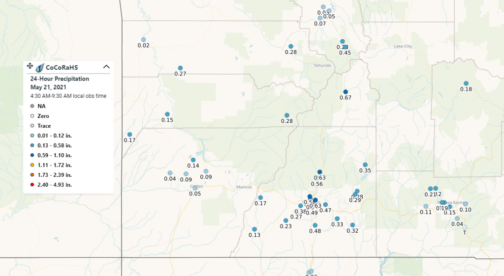
The map below shows radar-estimated, rainfall gage-adjusted Quantitative Precipitation Estimates (QPE) across Colorado. The map is updated daily during the operational season (May 1 – Sep 30) by 11AM. The following six layers are currently available: 24-hour, 48-hour and 72-hour total precipitation, as well as maximum 1-hour, 2-hour and 6-hour precipitation over the past 24 hour period (to estimate where flash flooding may have occurred). The accumulation ending time is 7AM of the date shown in the bottom right corner. Also shown optionally are vulnerable fire burn areas (post 2012), which are updated throughout the season to include new, vulnerable burn areas. The home button in the top left corner resets the map to the original zoom.

SPM 05-20-2021: Spring Thunderstorms and Continued Drought Improvement for Eastern Colorado

Issue Date: Thursday, May 20, 2021
Issue Time: 9:00 am MDT

Summary

Thunderstorms began to develop at high elevations in the North, Central, and Southeast mountains in the early afternoon yesterday, with some isolated heavy rain. Flood advisories were issued yesterday from the Boulder NWS for the Cameron Peak and East Troublesome burn scars due to thunderstorm activity and potential for heavy rain, as indicated by radar. However, no flooding was reported at these locations. A flood warning was also in place east of Pueblo due to the heavy rain and high river flows from the last few days of rain. Most of the thunderstorm activity diminished by early evening in the central portion of the state, but portions of the western slope saw overnight showers. For rainfall estimates in your area, check out our State Precipitation Map below.

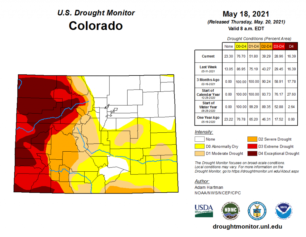
The wet week the eastern half of the state experienced has improved drought conditions, as seen in today’s update from the U.S. Drought Monitor below. Nearly the entire northeast quadrant of the state is no longer experiencing any drought conditions, along with a pocket of Huerfano and Pueblo counties. Overall, the percent area of the state experiencing no drought conditions increased to over 23%, compared to 13% last week, and 0% of the state just three months ago. On the western half of the state, extreme to exceptional drought conditions are still present, with really no change in the percent area from last week.

Click Here For Map Overview

The map below shows radar-estimated, rainfall gage-adjusted Quantitative Precipitation Estimates (QPE) across Colorado. The map is updated daily during the operational season (May 1 – Sep 30) by 11AM. The following six layers are currently available: 24-hour, 48-hour and 72-hour total precipitation, as well as maximum 1-hour, 2-hour and 6-hour precipitation over the past 24 hour period (to estimate where flash flooding may have occurred). The accumulation ending time is 7AM of the date shown in the bottom right corner. Also shown optionally are vulnerable fire burn areas (post 2012), which are updated throughout the season to include new, vulnerable burn areas. The home button in the top left corner resets the map to the original zoom.