Issue Date: Thursday, May 20, 2021
Issue Time: 9:00 am MDT
Summary
Thunderstorms began to develop at high elevations in the North, Central, and Southeast mountains in the early afternoon yesterday, with some isolated heavy rain. Flood advisories were issued yesterday from the Boulder NWS for the Cameron Peak and East Troublesome burn scars due to thunderstorm activity and potential for heavy rain, as indicated by radar. However, no flooding was reported at these locations. A flood warning was also in place east of Pueblo due to the heavy rain and high river flows from the last few days of rain. Most of the thunderstorm activity diminished by early evening in the central portion of the state, but portions of the western slope saw overnight showers. For rainfall estimates in your area, check out our State Precipitation Map below.
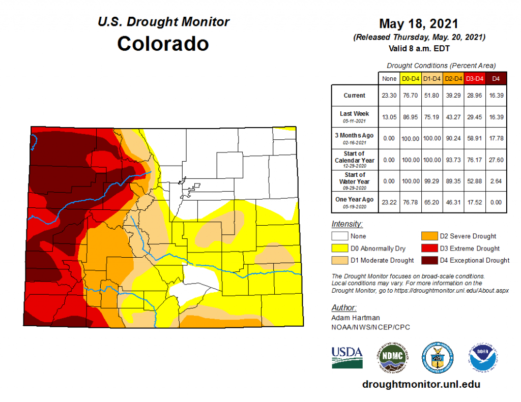
The wet week the eastern half of the state experienced has improved drought conditions, as seen in today’s update from the U.S. Drought Monitor below. Nearly the entire northeast quadrant of the state is no longer experiencing any drought conditions, along with a pocket of Huerfano and Pueblo counties. Overall, the percent area of the state experiencing no drought conditions increased to over 23%, compared to 13% last week, and 0% of the state just three months ago. On the western half of the state, extreme to exceptional drought conditions are still present, with really no change in the percent area from last week.
Click Here For Map Overview
The map below shows radar-estimated, rainfall gage-adjusted Quantitative Precipitation Estimates (QPE) across Colorado. The map is updated daily during the operational season (May 1 – Sep 30) by 11AM. The following six layers are currently available: 24-hour, 48-hour and 72-hour total precipitation, as well as maximum 1-hour, 2-hour and 6-hour precipitation over the past 24 hour period (to estimate where flash flooding may have occurred). The accumulation ending time is 7AM of the date shown in the bottom right corner. Also shown optionally are vulnerable fire burn areas (post 2012), which are updated throughout the season to include new, vulnerable burn areas. The home button in the top left corner resets the map to the original zoom.

