SPM 06-20-2021: Severe Weather on Eastern Plains

Issue Date: Sunday, June 20, 2021
Issue Time: 9:30 AM MDT

Summary:

Scattered thunderstorms began to develop in the high elevations of the Northern, Central, and Front Range Mountains in the early afternoon yesterday. As the storms progressed eastward, they tapped into additional moisture and instability, which allowed for larger and better organized lines of thunderstorms. This resulted in severe weather up and down the entire eastern half of the state yesterday. High winds and damaging hail were the biggest threats, and high wind reports were made from the Nebraska Border to the Oklahoma Border, including a 92 mph wind gust in Limon! Large hail, up to 1.25 inches, and several reports of a land spout tornadoes were made in Eastern Adams County in the Northeast Plains. In additional to the severe thunderstorms, widespread 0.25-0.50 inches of rain fell across much of the Northeast Plains, as seen on the map below.

Elsewhere, evening flash flood warnings were issued for the Junkins and Decker fire burn scars in the Central and Southeast Mountains as storms trained from west to east, however no actual flooding was reported. On the Western Slope, storms were less organized but some isolated showers dropped measurable precipitation, though generally light enough to not appear in the map below.

Flooding was not reported on Saturday. For rainfall estimates in your area, check out the State Precipitation map below.

Click Here For Map Overview

The map below shows radar-estimated, rainfall gage-adjusted Quantitative Precipitation Estimates (QPE) across Colorado. The map is updated daily during the operational season (May 1 – Sep 30) by 11AM. The following six layers are currently available: 24-hour, 48-hour and 72-hour total precipitation, as well as maximum 1-hour, 2-hour and 6-hour precipitation over the past 24 hour period (to estimate where flash flooding may have occurred). The 24-hour, 48-hour and 72-hour total precipitation contain bias corrections that are not disaggregated into the hourly estimates, so there will likely be some differences. The accumulation ending time is 7AM of the date shown in the bottom right corner. Also shown optionally are vulnerable fire burn areas (post 2012), which are updated throughout the season to include new, vulnerable burn areas. The home button in the top left corner resets the map to the original zoom.

SPM 06-19-2021: Widespread Afternoon and Evening Thunderstorms

Issue Date: Saturday, June 19, 2021
Issue Time: 9:35 AM MDT

Summary:

The atmosphere was active across Colorado yesterday, with the presence of a frontal passage from northeast moving south across the state in the early afternoon. This resulted in thunderstorms developing ahead of it along the Front Range Mountains and Eastern Plains. The Central and San Juan Mountains also had widespread thunderstorm activity in the afternoon yesterday, and benefited from increased atmospheric moisture, as discussed in the Flood Threat Bulletin yesterday.

Overall storms were fairly benign though. Rainfall rates did not exceed 0.25 inches/hour aside from a line of storms in Southwest Colorado. Low rainfall rates translated to similarly low rainfall totals, as seen in the State Precipitation Map below. There was some light hail reported, but nothing to reach severe designation, and a lone thunderstorm wind gust of 45 mph was reported at Garfield County Regional Airport. No flooding was reported on Friday. For additional rainfall totals in your area, check out the State Precipitation Map below.

Click Here For Map Overview
The map below shows radar-estimated, rainfall gage-adjusted Quantitative Precipitation Estimates (QPE) across Colorado. The map is updated daily during the operational season (May 1 – Sep 30) by 11AM. The following six layers are currently available: 24-hour, 48-hour and 72-hour total precipitation, as well as maximum 1-hour, 2-hour and 6-hour precipitation over the past 24 hour period (to estimate where flash flooding may have occurred). The 24-hour, 48-hour and 72-hour total precipitation contain bias corrections that are not disaggregated into the hourly estimates, so there will likely be some differences. The accumulation ending time is 7AM of the date shown in the bottom right corner. Also shown optionally are vulnerable fire burn areas (post 2012), which are updated throughout the season to include new, vulnerable burn areas. The home button in the top left corner resets the map to the original zoom.

SPM 06-18-2021: Heat Burst in Pueblo

Issue Date: Friday, June 18, 2021
Issue Time: 9:15 AM MDT

Summary:

Yesterday was the last day of especially hot weather across Colorado, with high 90s and 100s observed all across the state. There was scattered thunderstorm activity in the late afternoon and evening, however rainfall rates were low along with overall accumulation. For rainfall estimates in your area, check out the State Precipitation Map at the bottom of this post. Flooding was also not reported on Thursday.

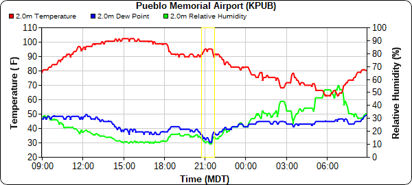
In other unusual weather news, a heat burst was observed at the NWS office in Pueblo around 9:00 pm last night.

During the heat burst, winds gusted up to 62 mph as the temperature quickly rose to 95 degrees and humidity decreased. The quick increase in temperature and decrease in dewpoint can be seen highlighted in yellow in the time series plot below from Pueblo Memorial Airport. Heat bursts are a rare occurrence, and the result of a dissipating thunderstorm and a hot and dry atmosphere. More information on heart bursts can be found here.

Click Here For Map Overview

The map below shows radar-estimated, rainfall gage-adjusted Quantitative Precipitation Estimates (QPE) across Colorado. The map is updated daily during the operational season (May 1 – Sep 30) by 11AM. The following six layers are currently available: 24-hour, 48-hour and 72-hour total precipitation, as well as maximum 1-hour, 2-hour and 6-hour precipitation over the past 24 hour period (to estimate where flash flooding may have occurred). The 24-hour, 48-hour and 72-hour total precipitation contain bias corrections that are not disaggregated into the hourly estimates, so there will likely be some differences. The accumulation ending time is 7AM of the date shown in the bottom right corner. Also shown optionally are vulnerable fire burn areas (post 2012), which are updated throughout the season to include new, vulnerable burn areas. The home button in the top left corner resets the map to the original zoom.

SPM 06-17-2021: Scattered Afternoon Showers, but Little Actual Precipitation

Issue Date: Thursday, June 17, 2021
Issue Time: 9:30 AM MDT

Summary:

Another high temperature record breaking day across the state yesterday, with highs well into the 90s and low 100s. However, there was more scattered precipitation yesterday which brought some brief relief in the form of cooler temperatures if you were lucky enough to be under a shower. High elevation convection began in the early afternoon up and down the Front Range Mountains, Southeast Mountains and San Juan Mountains, and even the Southwest Slope saw some light precipitation. A line of storms trained from southwest to northeast along the Palmer Ridge and Northeast plains, which can be seen in the Max 1-hr precipitation in the State Precipitation Map at the bottom of this post. While 1-hour rainfall rates were as high as 0.25 inches/hour along the line of storms, total precipitation that made it to the ground was ultimately much lighter. Instead, the major threat from the scattered storms was high winds. A 58-mph wind gust from thunderstorms was recorded at the Pueblo Airport yesterday afternoon.

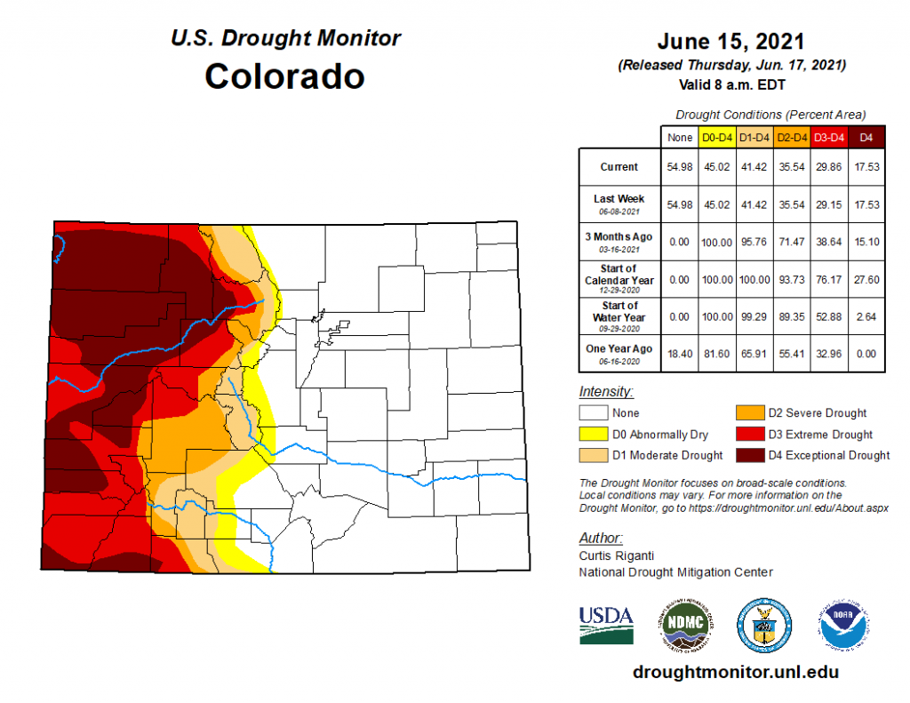
Since it’s Thursday, there’s also an update to the U.S. Drought Monitor, seen below. Drought conditions across Colorado are nearly identical to last week, with the very obvious divide between the eastern and western halves of the state persisting. The hot and dry weather hasn’t provided any relief to the Western Slope, which still has a very large are of D4 exceptional drought.

Flooding was not reported on Wednesday. For rainfall estimates in your area, check out the State Precipitation Map below.

Click Here For Map Overview

The map below shows radar-estimated, rainfall gage-adjusted Quantitative Precipitation Estimates (QPE) across Colorado. The map is updated daily during the operational season (May 1 – Sep 30) by 11AM. The following six layers are currently available: 24-hour, 48-hour and 72-hour total precipitation, as well as maximum 1-hour, 2-hour and 6-hour precipitation over the past 24 hour period (to estimate where flash flooding may have occurred). The 24-hour, 48-hour and 72-hour total precipitation contain bias corrections that are not disaggregated into the hourly estimates, so there will likely be some differences. The accumulation ending time is 7AM of the date shown in the bottom right corner. Also shown optionally are vulnerable fire burn areas (post 2012), which are updated throughout the season to include new, vulnerable burn areas. The home button in the top left corner resets the map to the original zoom.