Issue Date: Friday, June 18, 2021
Issue Time: 9:15 AM MDT
Summary:
Yesterday was the last day of especially hot weather across Colorado, with high 90s and 100s observed all across the state. There was scattered thunderstorm activity in the late afternoon and evening, however rainfall rates were low along with overall accumulation. For rainfall estimates in your area, check out the State Precipitation Map at the bottom of this post. Flooding was also not reported on Thursday.
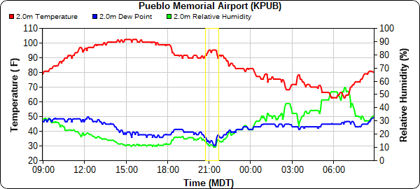
In other unusual weather news, a heat burst was observed at the NWS office in Pueblo around 9:00 pm last night.
At 8:55 pm this evening, a local “heat burst” occurred at the National Weather Service office at Pueblo. As the heat burst was occurring, it got very windy at the weather office and the temperature shot up to 95 degrees F.
— NWS Pueblo (@NWSPueblo) June 18, 2021
During the heat burst, winds gusted up to 62 mph as the temperature quickly rose to 95 degrees and humidity decreased. The quick increase in temperature and decrease in dewpoint can be seen highlighted in yellow in the time series plot below from Pueblo Memorial Airport. Heat bursts are a rare occurrence, and the result of a dissipating thunderstorm and a hot and dry atmosphere. More information on heart bursts can be found here.
Click Here For Map Overview

