SPM 09-24-2021: Weak Cold-Frontal Passage Brings Light, High-Elevation Snowfall

Issue Date: Friday, September 24th, 2021
Issue Time: 10:15 AM MDT

Summary:

Thursday started out overall uneventfully, with temperatures creeping back up just above seasonal normal across the state. By afternoon however, a weak but fast-moving cold-frontal passage made its away from north to south across the state. This helped to kick off isolated evening showers, including snow, in the high elevations of the Northern, Central, San Juan, and Front Range Mountains. Several SNOTEL stations scattered across the high elevations picked up 0.1 inches of liquid equivalent precipitation. For the rest of Colorado, dry weather prevailed. As expected, no flooding was reported on Thursday. For rainfall estimates (or lack thereof) in your area, check out the State Precipitation Map at the bottom of today’s post. Note: a small area of precipitation appears to be over the Lincoln-Kit Carson-Cheyenne county area. This is actually a radar artifact from a large wind farm, rather than precipitation.

Every year, SmokyMountains.com produces a fall foliage map highlighting which week peak fall colors will occur across the county. The wet spring and warm summer delayed peak fall foliage a bit across Colorado, but it has arrived for the northwest portion of the state. The slider map found here can help decide when to head out and where for the best leaf peeping!

Click Here For Map Overview

The map below shows radar-estimated, rainfall gage-adjusted Quantitative Precipitation Estimates (QPE) across Colorado. The map is updated daily during the operational season (May 1 – Sep 30) by 11AM. The following six layers are currently available: 24-hour, 48-hour and 72-hour total precipitation, as well as maximum 1-hour, 2-hour and 6-hour precipitation over the past 24 hour period (to estimate where flash flooding may have occurred). The accumulation ending time is 7AM of the date shown in the bottom right corner. Also shown optionally are vulnerable fire burn areas (post 2012), which are updated throughout the season to include new, vulnerable burn areas. The home button in the top left corner resets the map to the original zoom.

SPM 09-23-2021: Another Dry Day – Expanding Drought Conditions

Issue Date: Thursday, September 23rd, 2021
Issue Time: 9:50 AM MDT

Summary:

Thanks to the high-pressure ridge dominating the weather across Colorado, no precipitation was reported yesterday. Temperatures also continued to rise to above seasonal normal, with highs in the upper 70s and low 80s for much of the state. As expected, no flooding was reported on Wednesday. For rainfall estimates in your area, including antecedent rainfall, check out the State Precipitation Map at the bottom of today’s post.

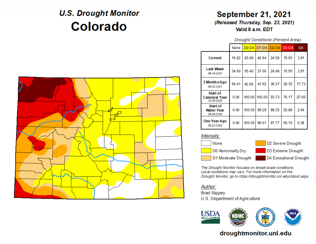
Today’s Drought Monitor update for conditions as of Tuesday, September 21 show drought expanding across much of Colorado. Last week, 34.6% of the state was not experiencing any type of drought, compared to only 16.92% as of this week. West of the divide, conditions remained largely the same, though with much of the region experiencing “D1 Moderate” to “D4 Exceptional” drought. The main expansion has been in “D0 Abnormally Dry” conditions across a large swatch of Central and Southern Colorado, covering portions of the San Juan Mountains, San Luis Valley, Front Range Mountains, Urban Corridor, Palmer Ridge, and Southeast Plains. Additionally, in the Southeast Plains areas of “D1 Moderate” drought have expanded from last week and a small area on the Oklahoma border in Baca County has been increased to “D2 Severe” drought. Only small pockets of Eastern Colorado remain with no drought conditions.

Click Here For Map Overview

The map below shows radar-estimated, rainfall gage-adjusted Quantitative Precipitation Estimates (QPE) across Colorado. The map is updated daily during the operational season (May 1 – Sep 30) by 11AM. The following six layers are currently available: 24-hour, 48-hour and 72-hour total precipitation, as well as maximum 1-hour, 2-hour and 6-hour precipitation over the past 24 hour period (to estimate where flash flooding may have occurred). The accumulation ending time is 7AM of the date shown in the bottom right corner. Also shown optionally are vulnerable fire burn areas (post 2012), which are updated throughout the season to include new, vulnerable burn areas. The home button in the top left corner resets the map to the original zoom.

SPM 09-22-2021: Cool, Calm Day Across State

Issue Date: Wednesday, September 22nd, 2021
Issue Time: 10:00 AM MDT

Summary:

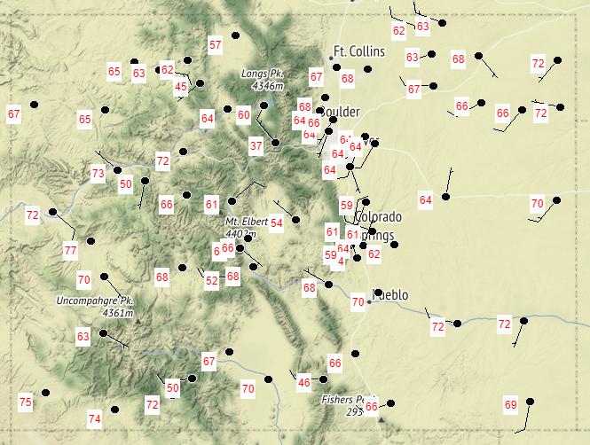
Tuesday began with some early morning showers associated with a weak frontal boundary on the far Southeast Plains, which quickly dissipated with daytime heating and the eastward progression of the larger scale departing trough. Total precipitation in this area was light, just less than 0.10 inches. For the rest of Colorado, it was a seasonably cool day. The following map shows yesterday’s high temperatures at all NWS stations, with highs in the 60s for most of the state, and low 70s for the Eastern Plains, Grand Valley, and Southwest Slope. Skies remained largely clear yesterday thanks to building high pressure, which will continue to dominate the weather pattern in the coming days.

Repairs at the Pueblo radar were also finished yesterday – the radar is now back online and operational.

No flooding was reported on Tuesday. For rainfall estimates in your area, check out the State Precipitation Map below.

Click Here For Map Overview

The map below shows radar-estimated, rainfall gage-adjusted Quantitative Precipitation Estimates (QPE) across Colorado. The map is updated daily during the operational season (May 1 – Sep 30) by 11AM. The following six layers are currently available: 24-hour, 48-hour and 72-hour total precipitation, as well as maximum 1-hour, 2-hour and 6-hour precipitation over the past 24 hour period (to estimate where flash flooding may have occurred). The accumulation ending time is 7AM of the date shown in the bottom right corner. Also shown optionally are vulnerable fire burn areas (post 2012), which are updated throughout the season to include new, vulnerable burn areas. The home button in the top left corner resets the map to the original zoom.

SPM 09-21-2021: Much Cooler Day with Showers in Mountains and Eastern Colorado

Issue Date: Tuesday, September 21st, 2021
Issue Time: 10:15 AM MDT

Summary:

Monday was a much cooler day than we’ve been experiencing lately, with highs only in the 60s and low 70s for the Western Slopes, Grand Valley, Urban Corridor, Southeast Mountains, San Juan Valley and Eastern Plains, and 50s for the Northern, Central and San Juan Mountains. In fact, overnight and early morning lows have been some of the coolest that have been seen since late spring.

In terms of precipitation, the morning kicked off with the end of the trough axis that brought these big changes exiting the Northwest Plains and any lingering light showers dissipating. However, further west early morning showers and even light snow was falling over the Northern and Central mountains. Precipitation totals for the high elevations vary from 0.01-0.40 inches scattered across the region.

By early afternoon, a weak front interacting with the Palmer Divide north of Colorado Springs brought light precipitation to the Urban Corridor and Palmer Ridge. As the afternoon progressed, storms became more widespread over Palmer Ridge and Urban Corridor, and expanding out to the Northeast and Southeast Plains by evening and overnight hours. Precipitation totals were modest and rainfall rates remained light enough to prevent any runoff. Some notable totals from CoCoRaHS observers across the eastern half of the state include 0.37 inches in Denver, though mostly surrounding by 0.05-0.15 inch totals, 0.28 inches in Black Forest, and 0.20 inches in Limon and Brush.

No flooding was reported on Monday. For rainfall estimates in your area, check out the State Precipitation Map below.

The Pueblo radar is currently being upgraded and is offline for the next few weeks, so radar-based precipitation estimates for Southeast Colorado are having to rely on further radars in Denver, New Mexico, Texas, and Kansas. This will result in precipitation being underestimated for this region. More information the radar upgrade can be found here.

Click Here For Map Overview

The map below shows radar-estimated, rainfall gage-adjusted Quantitative Precipitation Estimates (QPE) across Colorado. The map is updated daily during the operational season (May 1 – Sep 30) by 11AM. The following six layers are currently available: 24-hour, 48-hour and 72-hour total precipitation, as well as maximum 1-hour, 2-hour and 6-hour precipitation over the past 24 hour period (to estimate where flash flooding may have occurred). The accumulation ending time is 7AM of the date shown in the bottom right corner. Also shown optionally are vulnerable fire burn areas (post 2012), which are updated throughout the season to include new, vulnerable burn areas. The home button in the top left corner resets the map to the original zoom.