STP 05-22-2015: Rain For Most, And Even Snow, As Soggy Spring Continues

Issue Date: Friday, May 22nd, 2015
Issue Time: 8:58 AM MDT

Summary:

FLOOD WARNINGS CONTINUE FOR PORTIONS OF THE CACHE LA POUDRE, SOUTH PLATTE, PURGATOIRE, AND ARKANSAS RIVERS.

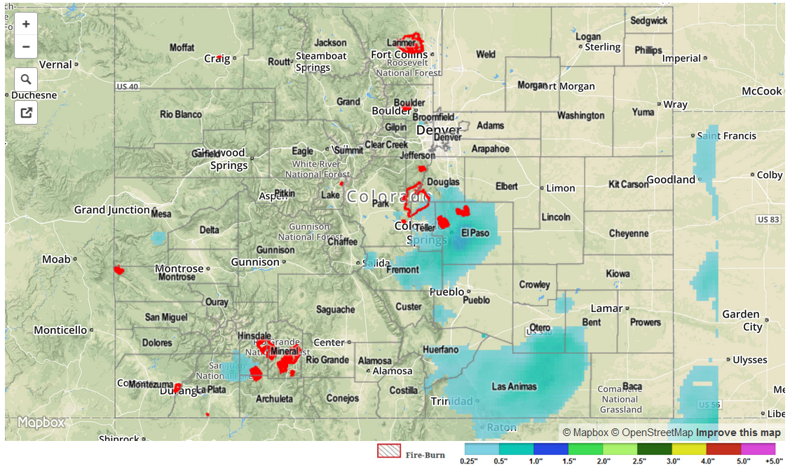
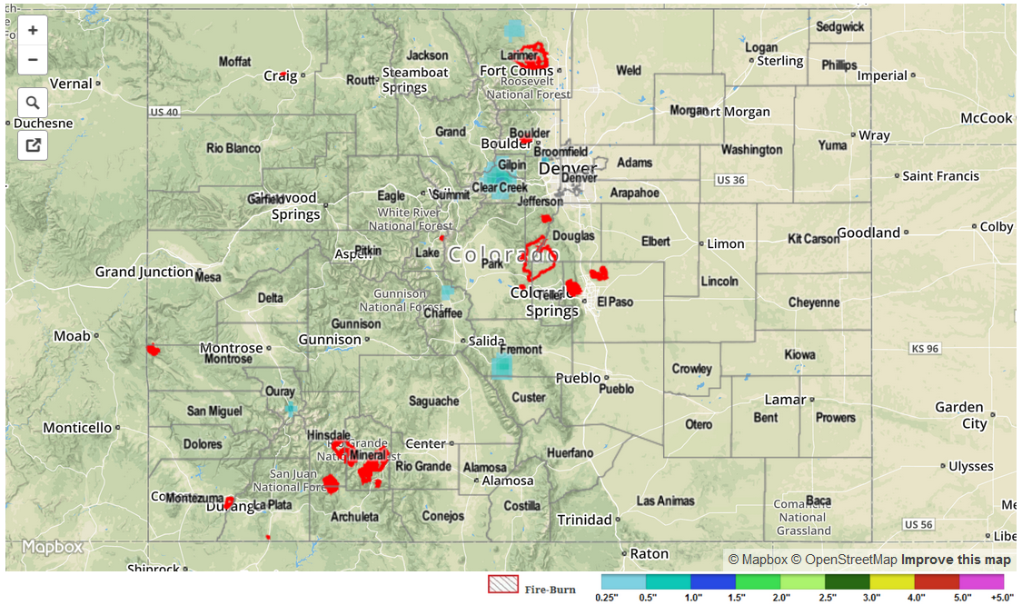
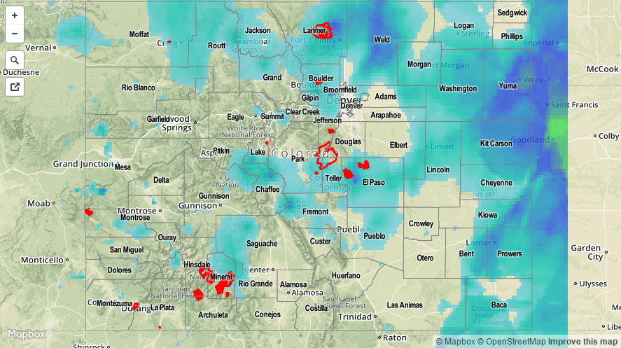
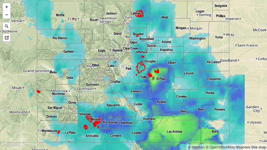
Thursday was overcast and dreary for most of Colorado. The sun broke through the clouds in the south and west, only to be overtaken by new clouds as the afternoon destabilized under the strong May sun. From late afternoon and into the overnight hours, a marked disturbance passed over eastern Colorado, causing thundershowers and more general rain. Weak instability and relatively fast storm motion limited rain rates to about 0.5 inches per hour. A report of pea sized hail was received from Dolores County as a weak thunderstorm popped up overhead. Meanwhile, 1-3 inches of snow were reported at several elevations above about 8,000 feet.

A handful or so observers reported rainfall above 1 inch. These occurred in Lincoln, Fremont and Garfield counties. Three Areal Flood Advisories were issued by the National Weather Service in addition to the Flood Warnings for portions of the South Platte and Arkansas Rivers that continue into this morning.

No flooding was officially reported yesterday, but many streams and rivers in the Northeast Plains, Palmer Ridge and Southeast Plains continue to run in Minor flood stage as soils remain saturated.

As always, please check the map below for estimated rainfall in your area.

STP_snapshot_20150522

STP 05-21-2015: Mother Nature Continues Her Cool Hold on Colorado

Issue Date: Thursday, May 21st, 2015
Issue Time: 9:00 AM MDT

Summary:

FLOOD WARNINGS CONTINUE FOR PORTIONS OF THE CACHE LA POUDRE, SOUTH PLATTE, PURGATOIRE, AND ARKANSAS RIVERS.

Another cooler-than-average day across Colorado provided a few light showers and weak thunderstorms, with most rainfall totals coming in under 0.10 inches. A few snow showers dotted the higher peaks, resulting in light accumulations, and clouds and fog remained socked in across the I-25 corridor thanks to easterly surface winds. Thanks in part to those clouds over the Urban Corridor, high temperatures at many locations in the region didn’t reach the 50 degree mark; a downright chilly day for the second-half of May.

No flash flooding occurred yesterday.

STP_snapshot_20150521

STP 05-20-2015: Another Cool and Wet Day: Snow for the Higher Elevations, Rain for Lower Elevations

Issue Date: Wednesday, May 20th, 2015
Issue Time: 9:00 AM MDT

Summary:

FLOOD WARNINGS CONTINUE FOR PORTIONS OF THE CACHE LA POUDRE, SOUTH PLATTE, BIG THOMPSON, AND ARKANSAS RIVERS.

Yesterday morning saw widespread rain and snow across much of Colorado before the large precipitation shield “exited” the state to the north. Behind that, though, another bout with showers and thunderstorms loomed for the afternoon and overnight hours. Snow fell above 10,000 feet during the day, lowering to about 9,000 feet overnight, with elevations lower than that receiving rain. The greatest rainfall totals occurred across the eastern half of Colorado, namely the Front Range, Urban Corridor, Palmer Ridge, Raton Ridge, Southeast Plains, and Northeast Plains. Some of the big winners, according to CoCoRaHS observers were:

Baca County: 1.63 inches
Larimer County: 1.57 inches
Elbert County: 1.11 inches
Phillips County: 1.11 inches
Yuma County: 1.10 inches
Morgan County: 1.03 inches

For a complete statewide overview of precipitation, be sure and check out the STP map below.

20150520_STPImage
Storm Total Precip Legend

STP 05-19-2015: Cool and Quiet for Most of the Day, Snow and Heavy Rain Picking Up During the Overnight Hours

Issue Date: Tuesday, May 19th, 2015
Issue Time: 9:00 AM MDT

Summary:

FLASH FLOOD WARNINGS ARE CURRENTLY ONGOING IN EL PASO AND PUEBLO COUNTIES, WITH FLOOD ADVISORIES IN PLACE FOR NORTHWESTERN LAS ANIMAS AND NORTHEASTERN HUERFANO COUNTIES. ADDITIONALLY, AN URBAN AND SMALL STREAM FLOOD ADVISORY IS IN PLACE FOR ELBERT, PHILLIPS, EASTERN ADAMS, ARAPAHOE, MORGAN, WELD, LINCOLN, LOGAN, SEDGWICK, AND WASHINGTON COUNTIES.

In what has been a wet May, overnight and this morning has been no different; Colorado Springs has already broken the daily precipitation record for May 19, as of 5 am, with 0.92 inches of rain and still falling. At 6 AM, a 12-hour rain total of 1.12 inches was reported 3 miles North of the Pueblo Reservoir in Pueblo County, and a 6-hour rain total of 1.21 inches was reported 3 miles NNE of Blende in Pueblo County. Additionally, 3.5 inches of snow had fallen in Poncha Springs (Chaffee County) between 2 AM and 6 AM. A few more heavy rain reports (as of 6 AM) include:

5 miles NNE of Spanish Peaks (Huerfano): 2.20 inches
4 miles SW of Colorado Springs (El Paso): 2.20 inches
6 miles ESE of Thatcher (Las Animas): 2.03 inches
6 miles W of Fountain (El Paso): 1.84 inches
3 miles N of Manitou Springs (El Paso): 1.58 inches
Colorado Springs (El Paso): 1.57 inches
9 miles NE of Penrose (El Paso): 1.53 inches

For a complete statewide overview of precipitation, be sure and check out the STP map below.

20150519_STPImage
Storm Total Precip Legend