Issue Date: Tuesday, May 19th, 2015
Issue Time: 9:00 AM MDT
Summary:
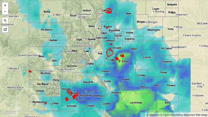
FLASH FLOOD WARNINGS ARE CURRENTLY ONGOING IN EL PASO AND PUEBLO COUNTIES, WITH FLOOD ADVISORIES IN PLACE FOR NORTHWESTERN LAS ANIMAS AND NORTHEASTERN HUERFANO COUNTIES. ADDITIONALLY, AN URBAN AND SMALL STREAM FLOOD ADVISORY IS IN PLACE FOR ELBERT, PHILLIPS, EASTERN ADAMS, ARAPAHOE, MORGAN, WELD, LINCOLN, LOGAN, SEDGWICK, AND WASHINGTON COUNTIES.
In what has been a wet May, overnight and this morning has been no different; Colorado Springs has already broken the daily precipitation record for May 19, as of 5 am, with 0.92 inches of rain and still falling. At 6 AM, a 12-hour rain total of 1.12 inches was reported 3 miles North of the Pueblo Reservoir in Pueblo County, and a 6-hour rain total of 1.21 inches was reported 3 miles NNE of Blende in Pueblo County. Additionally, 3.5 inches of snow had fallen in Poncha Springs (Chaffee County) between 2 AM and 6 AM. A few more heavy rain reports (as of 6 AM) include:
5 miles NNE of Spanish Peaks (Huerfano): 2.20 inches
4 miles SW of Colorado Springs (El Paso): 2.20 inches
6 miles ESE of Thatcher (Las Animas): 2.03 inches
6 miles W of Fountain (El Paso): 1.84 inches
3 miles N of Manitou Springs (El Paso): 1.58 inches
Colorado Springs (El Paso): 1.57 inches
9 miles NE of Penrose (El Paso): 1.53 inches
For a complete statewide overview of precipitation, be sure and check out the STP map below.