STP 05-25-2016: Strong-to-Severe Thunderstorms Rumbled Across Northeast Colorado

Issue Date: Friday, May 1st, 2015
Issue Time: 9:00 AM MDT

Summary:

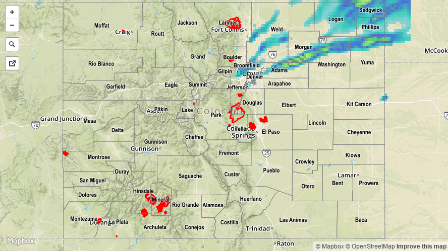
An upper-level disturbance helped kick off an afternoon of isolated-to-scattered showers/thunderstorms across northern Colorado, mainly east of the Continental Divide. The presence of increasing moisture at the surface, instability, and favorable wind shear led to the development of severe strong-to-severe thunderstorms across the Urban Corridor and Northeast Plains regions. Moderate-to-heavy rain fell from thunderstorms, in addition to a plethora of severe weather impacts. A few of the more significant severe storm reports include:

1.75 inch hail: S of Akron (Washington County), 6 miles SSE of Denver (Denver County)

1.5 inch hail: 1 mile W of Platner (Washington County), SE of Akron (Washington County), 2 miles NE of Denver (Denver County), 2 miles ESE of Denver (Denver County)

Tornado: Akron (Washington County), S of Akron (Washington County), 10 miles NW of Last Chance (Adams County)

Elsewhere, during the evening and overnight hours, isolated showers developed over the higher terrain of northwestern Colorado. These showers produced mainly light rain and gusty winds.

Rainfall winners, according to CoCoRaHS (reports as of 7:00 AM MDT):

Yuma County: 0.82 inches
Phillips County: 0.79 inches
Sedgwick County: 0.74 inches
Adams County: 0.56 inches
Weld County: 0.45 inches

No flash flooding occurred yesterday. For a look at 24-hour precipitation, please see the STP map below. It is important to note that hail contamination will be present in the STP map, so rainfall totals are likely lower than what is shown in most locations.

20160525_STPImage
Storm Total Precip Legend

STP 05-24-2016: Cooler Overall with Isolated-to-Widely Scattered Thunderstorms

Issue Date: Tuesday, May 24th, 2016
Issue Time: 9:00 AM MDT

Summary:

Most places were blessed with abundant sunshine yesterday, owing to the continued transport of drier air aloft into Colorado. Not everything was sunny, however, as a jet streak moving overhead plus the presence of a weak frontal boundary kicked off a few thunderstorms during the afternoon and evening, with a few continuing into the overnight hours across northeastern Colorado. One severe storm observation was reported to the National Weather Service: 3 miles NW of Elba (Washington County), 1 inch hail fell and caused some minor tree damage.

Rainfall winners, according to CoCoRaHS (reports as of 7:00 AM MDT):

Adams County: 0.29 inches
Yuma County: 0.25 inches
Larimer County: 0.10 inches

It is important to keep in mind that observations are fairly sparse out on the plains, and higher rain totals may be missed due to gaps in coverage. For a more complete picture of 24-hour precipitation, please see the STP map below.

No flash flooding occurred yesterday.

20160524_STPImage
Storm Total Precip Legend

STP 05-23-2016: Warm and Mostly Sunny Overall, A Few Showers/Thunderstorms

Issue Date: Monday, May 23rd, 2016
Issue Time: 9:00 AM MDT

Summary:

As the upper-level low shifted to the northeast yesterday, it ushered drier and slightly cooler air into Colorado. Meanwhile, a dryline laid across the far eastern plains. Everything together kept much of the state capped off, refusing to budge for any showers/thunderstorms. There were three exceptions to this:

  1. The central and northern mountains, where a few isolated high-based showers/storms developed during the afternoon and early evening, producing more wind than rain.
  2. Along and east of the dryline, where one or two isolated thunderstorms rumbled. This activity quickly moved into Kansas and had very little impact in Colorado
  3. Over the northern half of the Urban Corridor and adjacent Northeast Plains during the evening/overnight hours. A narrow ribbon of lift moved across the area, producing isolated-to-widely scattered showers along a narrow SW-to-NE oriented corridor. Brief light-to-moderate rainfall resulted.

No flash flooding occurred yesterday. For a look at 24-hour precipitation, please see the STP map below.

20160523_STPImage
Storm Total Precip Legend

STP 05-22-2016: Isolated Thunderstorms Rumbled, Otherwise Mostly Sunny and Dry

Issue Date: Friday, May 1st, 2015
Issue Time: 9:00 AM MDT

Summary:

Warm air aloft over drying lower levels kept much of Colorado capped off yesterday, only allowing for a few isolated showers/thunderstorms. The strongest storms rumbled east of the dryline across the far eastern plains, but they quickly moved into Kansas. Overall, yesterday could be categorized by the sunshine and warmth that most areas experienced, as well as the windy conditions across western Colorado. Overnight, isolated-to-scattered showers moved into northwestern Colorado, associated with the approaching cool front, and brought very little rain.

No flash flooding occurred yesterday. Please see the STP map below for a look at 24-hour precipitation totals.

20160522_STPImage
Storm Total Precip Legend