STP 06-22-2016: Extreme Heat For Some, Along With Scattered Afternoon Storms

Issue Date: Wednesday, June 22nd, 2016
Issue Time: 9:25AM MDT

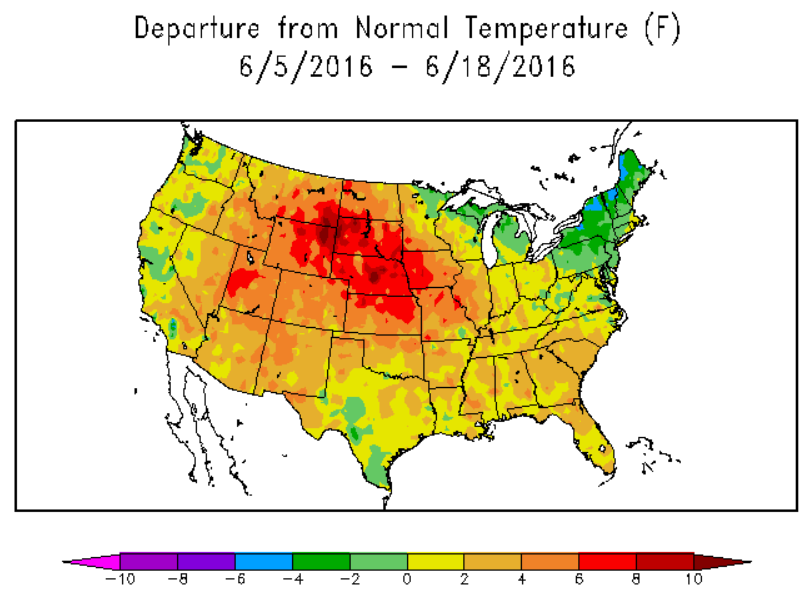
Very hot temperatures were the main story across Colorado on Tuesday. Here’s a sampling of some afternoon high temperatures: Lamar 107F, Pueblo 105F, Grand Junction 104F, Colorado Springs 101F (ties all-time record), Boulder 99F, Cortez 99F, Denver Intl. Airport 98F, Monument 89F.

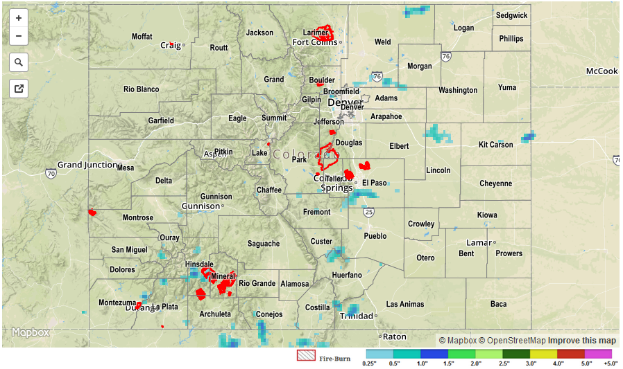
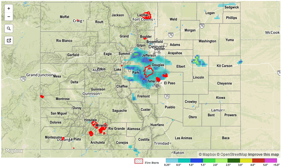
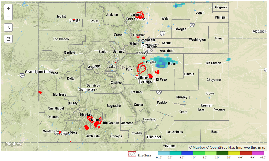
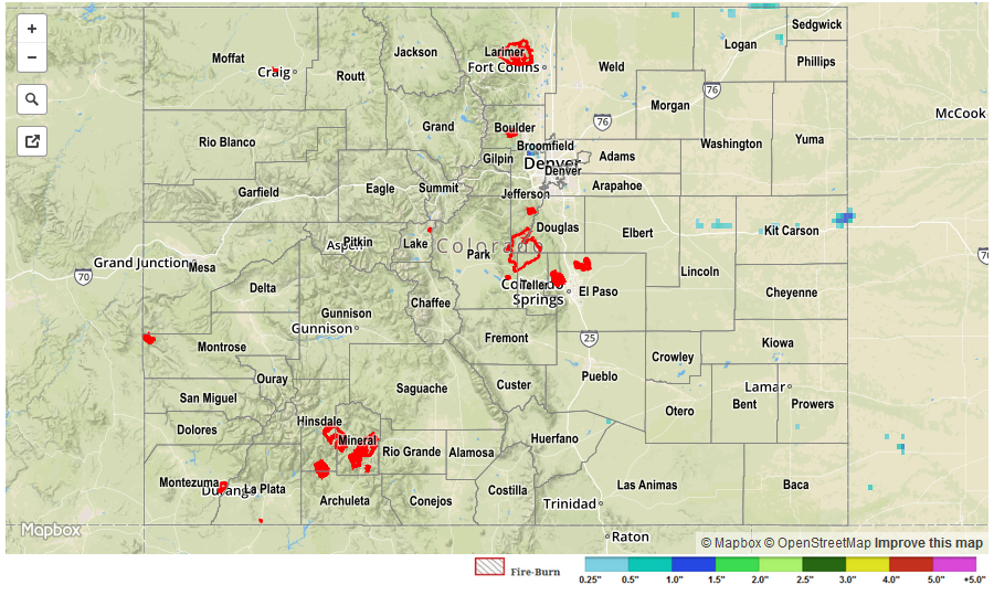
Despite the not-so-favorable conditions for brewing thunderstorms (due to the strong upper-level ridge overhead), the very warm temperatures provided enough instability for many high-elevation storms. However, their bark was louder than their bite. Highest 24-hour rainfall totals occurred in El Paso County with only 0.65 inches. Most other locations saw a trace to 0.25 inches of rainfall. Gusty winds, up to 45 mph, accompanied the passage of storms for many locations providing a nice relief from the intense afternoon heat.

As expected, the elevated wildfire risk did indeed result in at least one new major fire in northern Jackson County. As of this morning, the Beaver Creek Fire stood at 3,800 acres with substantial containment efforts underway.

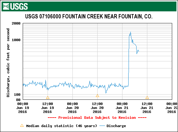
No flooding reports were received yesterday. For specific rainfall estimates in your area, check out our Storm Total Precipitation map below. Note that due to the dry sub-cloud layer statewide yesterday, the radar-estimated totals overestimate observed rainfall.

STP_20160622

STP 06-21-2016: Very Heavy Localized Rainfall Over Palmer Ridge

Issue Date: Tuesday, June 21st, 2016
Issue Time: 9:00AM MDT

A pool of cool moist air pushed into Colorado from the northeast on Monday morning, helping to stabilize the atmosphere and limit highs to the 70s in parts of the Northeast Plains and Urban Corridor. However, that same air helped to spark off some impressive late afternoon thunderstorms as it lifted over the Palmer Ridge and Front Range foothills and mixed with much warmer air. Very heavy short-term rainfalls were observed in Douglas, Park, Teller, Fremont and El Paso counties. Several Urban Drainage and Flood Control District gages picked up about 0.5 inches in 10 minutes. A USGS gage north of Colorado Springs picked up about 1.5 inches per hour. Highest 24-hour totals were in the 1.5 to 2.0 inch range for that region. The flow at Fountain Creek spiked in the late evening and overnight hours, as shown in the hydrograph below. Three Areal Flood Advisories were issued, as was a Flash Flood Warning for the Waldo Canyon burn scar.

fountain_creek_discharge

In addition to the heavy rainfall, a few stronger storms produced hail up to 1.75 inches in diameter. A rare tornado warning was also issued for Park County.

Elsewhere, very hot temperatures were the story over the southeast and western parts of the state. Grand Junction, Pueblo, Lamar and La Junta all surpassed the 100F mark, which is the second day in a row for this feat for the latter three sites.

No official flooding reports were received yesterday. For specific rainfall estimates in your area, check out our Storm Total Precipitation map below.

STP_20160621

STP 06-20-2016: Heat Dominates During The Day, A Few Storms Rumble In The Evening

Issue Date: Monday, June 20th, 2016
Issue Time: 9:15AM MDT

The Rocky Mountain ridge was at its strongest point during its past ~2 weeks of existence leading to very hot afternoon temperatures statewide. Here are some of the specifics: 99F in Boulder, 103F in Pueblo and La Junta, 97F at DIA, 98F at Grand Junction and 96F at Cortez. Yesterday was the warmest day in a string of very warm weather covering the state during the past two weeks or so. Since June 1st, temperatures across Colorado have been 3-10F above average.

While most of the day stayed dry, a weak frontal boundary kicked off a handful of weak to moderate thunderstorms on the north face of the Palmer Ridge. One particular cell stood out as it moved from Douglas into Elbert County. Hail up to 1.25 inches and heavy rainfall, up to about 0.75 inches per hour was noted with this storm prompting several severe thunderstorm warnings and even an areal flood advisory from the Boulder National Weather Service. In all, four reports of 1+ inch rainfall was observed in the area. However, flooding was not reported.

For specific rainfall estimates in your area, check out our Storm Total Precipitation map below.

STP_20160620

STP 06-19-2016: Heat Continued To Be The Story; Wildfire Activity Increased

Issue Date: Sunday, June 19th, 2016
Issue Time: 9:00AM MDT

With the ridge continuing its dominance, hot temperatures once again covered all of Colorado on Saturday. Afternoon high temperatures were anywhere from 5-10F above seasonal averages. In fact, data from the High Plains Regional Climate Center, below, shows that the past two weeks have been quite warm across Colorado as well as the Central Plains overall.

hpcc_tempanomWith the persistent warm and dry weather, soil moisture continues to decrease and wildfire activity has gradually increased across the southwest U.S. As of this morning, about half a dozen wildfires, scattered across the state, are either ongoing or have been recently contained. These range from a few acres to several thousand acres. Check out the #COfire Twitter thread for the latest information.

Flooding was not reported on Saturday.

STP_20160619