STP 07-12-2016: A Few Showers/Thunderstorms Returned to Eastern Colorado

Issue Date: Tuesday, July 12th, 2016
Issue Time: 9:00 AM MDT

Summary:

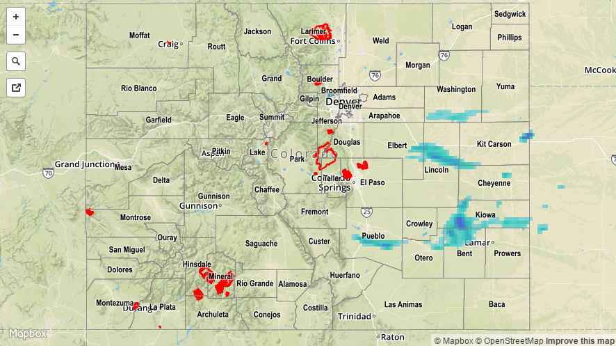
A couple lines of showers/thunderstorms developed across eastern Colorado during the afternoon and evening, at first over the Northeast Plains, and eventually back into the Palmer Ridge, Urban Corridor, and Southeast Plains as an outflow boundary pushed west-southwestward. A few storms continued into the nighttime and early morning hours, producing periods of moderate rainfall, gusty winds, and lightning. Most storms stayed over rural areas, with the best rain falling across Washington, Lincoln, Elbert, Kiowa, Bent, Otero, and Pueblo counties. Otherwise, temperatures yesterday were cooler than previous’ days, but gusty winds kept fire danger elevated across portions of the state.

For a statewide look at 24-hour precipitation totals, please take a look at the Storm Total Precipitation map below.

20160712_STPImage
Storm Total Precip Legend

STP 07-11-2016: Multiple Fires Burning Across the State

Issue Date: Monday, July 11th, 2016
Issue Time: 9:00 AM MDT

Summary:

An upper-level low transitioned eastward across the northwest US, tightening the pressure gradient across Colorado, leading to gusty winds. In fact, the following non-thunderstorm wind gusts were recorded:

52 mph: Mount Abrams (Ouray County), 2 miles SE of Silverton (San Juan County)
55 mph: 2 miles SW of Swamp Angel, near Red Mountain Pass (San Juan County)

Meanwhile, dry air was transported in from the west/southwest, and high fire danger was the result. The following fires are ongoing across Colorado:

Beaver Creek Fire (Jackson County)
Cold Springs Fire (Boulder County)
Spring Gulch Fire (Douglas County)
Hayden Pass Fire (Fremont County)

For a statewide look at 24-hour precipitation totals, please take a look at the Storm Total Precipitation map below.

20160711_STPImage
Storm Total Precip Legend

STP 07-10-2016: Hot and Dry Most Places, Isolated Thunderstorms for Far Eastern Colorado

Issue Date: Sunday, July 10th, 2015
Issue Time: 9:00 AM MDT

Summary:

With upper-level ridging overhead, and drier air moving in from the west, Colorado experienced plenty of sunshine and warmth yesterday. High temperatures were above average in most locations. In fact, Pueblo set a record high (102 F) that broke the previous mark set back in 2002 (101 F). A couple isolated storms were able to develop over far eastern Colorado, where better moisture was able to hang on to the east of a surface trough.

The “storm of the day” occurred over Baca County, producing large hail, heavy rain, strong winds, and lightning. Two severe storm reports were issued for that storm, both for hail: 1.50 inch hail fell 1 mile NW of Pritchett, and 1.75 inch hail fell in Pritchett. Underneath this storm, localized street/field ponding likely occurred in Pritchett.

For a closer look at rainfall totals in your area, please see the STP map below for a look at 24-hour precipitation totals.

20160710_STPImage
Storm Total Precip Legend

STP 07-09-2016: Isolated-to-Scattered Thunderstorms Rumbled Across Eastern Colorado

Issue Date: Saturday, July 9th, 2016
Issue Time: 9:00 AM MDT

Summary:

East/southeasterly flow reinforced moisture east of the mountains yesterday, providing the fuel for an afternoon/evening of isolated-to-scattered showers and thunderstorms. Combined with strong daytime heating, the unstable air mass over eastern Colorado supported a few strong/severe thunderstorms that produced heavy rainfall, hail, lightning, and strong winds. Severe storm reports are as follows:

2.5 inch hail: 2 miles ESE of Monument (El Paso)
1.75 inch hail: 5 miles SSW of Black Forest (El Paso)
1.25 inch hail: 4 miles SSW of Black Forest (El Paso) and 2 miles SW of Black Forest (El Paso)
1.0 inch hail: 1 mile N of Air Force Academy (El Paso), 3 miles N of Falcon (El Paso), 2 miles NNE of Fountain (El Paso), 3 miles SE of Colorado City (Pueblo), and 3 miles ENE of Air Force Academy (El Paso)

Flash flooding was reported 1 mile SE of Security, where runoff was flowing over the curb and impacting traffic. Additionally, street flooding/ponding was reported on I-25 between Interquest Parkway and Monument Hill due to heavy rain and hail.

Scattered showers and storms also develop over portions of the High Country, mainly along/east of the Continental Divide during the afternoon. These storms had access to less moisture, and were more of the garden variety.

For a closer look at rainfall totals in your area, please see the STP map below for a look at 24-hour precipitation totals.

20160709_STPImage
Storm Total Precip Legend