STP 08-17-2016: Uptick in Coverage/Intensity of Showers and Thunderstorms

Issue Date: Wednesday, August 17th, 2016
Issue Time: 9:00 AM MDT

Summary:

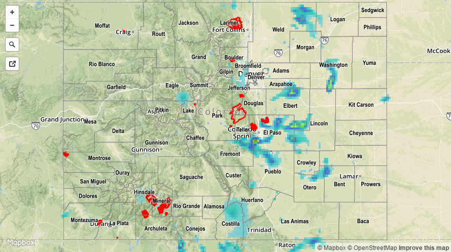
Better mid-level moisture was transported into the state yesterday, raising IPW values to above 0.75 inches for much of the state. This increase in moisture, combined with the passage of a mid-level disturbance, provided support for greater coverage/intensity of showers/storms as compared to Monday. Most of the moisture existed between 2.5 and 3.5 km above ground level, which cut down on effective rain rates at the surface for most locations. However, as is typical of Colorado’s atmosphere, one region outperformed the rest thanks to slow-moving storms and their ability to moisten the lower-levels. While no flash flooding has been reported, street/field ponding likely occurred across portions of El Paso and Pueblo counties, thanks in part to small hail creating drainage issues as heavy rain fell. The following heavy rain observations were reported:

1.75 inches: 9 miles WSW of Fountain (El Paso), 6 miles NNE of Colorado Springs (El Paso)
1.50 inches (in 50 minutes): 3 miles NNE of Schriever AFB (El Paso)
1.49 inches: 6 miles SE of the Air Force Academy (El Paso)
1.07 inches: 6 miles SSE of the Air Force Academy (El Paso)
0.99 inches: 6 miles NW of Peterson AFB (El Paso)
0.97 inches: 4 miles NE of Blende (Pueblo)

For a statewide look at 24-hour precipitation totals, please take a look at the Storm Total Precipitation map below.

20160817_STPImage
Storm Total Precip Legend

STP 08-16-2016: Uptick in Showers and Thunderstorms

Issue Date: Tuesday, August 16th, 2016
Issue Time: 9:00 AM MDT

Summary:

A weak mid-level disturbance rotated across the state yesterday, bringing an increase in moisture and showers/thunderstorms. Even with the increase in mid-level moisture, precipitable water values could only climb to near 0.8 inches at the normal reporting stations thanks to a general lack of low-level moisture. This setup mitigated any threat from heavy rain, with the main impacts being gusty winds, lightning, and light-to-moderate rainfall. Low-level moisture was a bit better over the far eastern plains, allowing for brief periods of heavy rainfall underneath thunderstorms. Even so, no flash flooding was reported as rain rates remained below threshold.

For a statewide look at 24-hour precipitation totals, please take a look at the Storm Total Precipitation map below.

20160816_STPImage
Storm Total Precip Legend

STP 08-15-2016: Drier and Warmer Overall

Issue Date: Monday, August 15th, 2016
Issue Time: 9:00 AM MDT

Summary:

As the upper-level ridge built overhead, drier air was transported in from the west, resulting in a quiet day overall. Only a couple isolated showers/weak thunderstorms were able to form over the higher terrain of the San Juan Mountains, Front Range, Southeast Mountains, and Central Mountains, while mid-level warming helped to cap off the lower elevations and squash any convection. Rainfall totals were light where any rain did fall, and no heavy rain/flash flooding was reported.

For a statewide look at 24-hour precipitation totals, please take a look at the Storm Total Precipitation map below.

20160815_STPImage
Storm Total Precip Legend

STP 08-14-2016: More Activity East of the Divide, Mainly Quiet West

Issue Date: Sunday, August 14th, 2016
Issue Time: 9:00 AM MDT

Summary:

A weak disturbance aloft and better instability helped produce more shower/thunderstorm activity along/east of the Divide yesterday (as compared to Friday). Wind shear was sufficient enough to support a few stronger thunderstorms, producing gusty winds, hail, and periods of moderate-to-heavy rainfall. No flash flooding was reported, however, as deep moisture was lacking. West of the Divide, a few isolated showers were able to develop over the higher terrain as the disturbance passed through, but a lack of moisture limited what Mother Nature could accomplish.
According to CoCoRaHS observers, these were the rainfall “winners” from the past 24 hours (as of 7:00 AM MDT):

Kiowa County: 0.55 inches
Prowers County: 0.44 inches
Weld County: 0.41 inches
El Paso County: 0.40 inches
Huerfano County: 0.33 inches
Fremont County: 0.30 inches

No flash flooding was reported. For a closer look at rainfall totals in your area, please see the STP map below for a look at 24-hour precipitation totals.


Storm Total Precip Legend