STP 05-20-2017: Departing Storm Continued To Produce Rain For Eastern Areas

Issue Date: Saturday, May 20th, 2017
Issue Time: 10AM MDT

Summary:

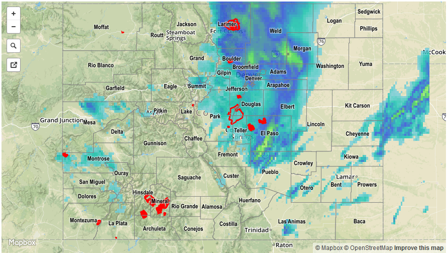
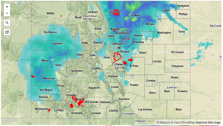
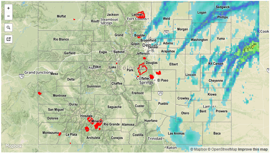
Showers (with a few snowflakes mixed in) continued across mainly the Northeast Plains and northern parts of the Urban Corridor as the disturbance responsible for Thursday’s snowstorm continued to slowly trek out of Colorado. Over 1 inch of light to moderate rainfall was observed in Logan and Yuma counties with many other neighboring regions tallying between 0.25 and 0.75 inches of rain. Across the Continental Divide, residual moisture caused upslope rain and snow showers in the Grand Valley, Central Mountains and Northern Mountains. However, total precipitation remained below 0.25 inches.

A 
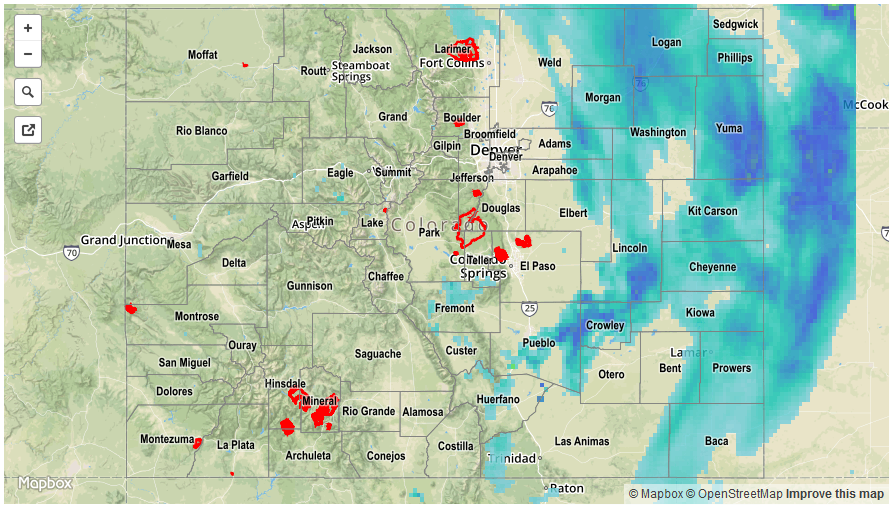
bit of the recent snow was able to melt (or maybe more like compress) on Friday, but this was limited by a persistent low cloud deck especially east of the Continental Divide. As of this morning, many areas in the Front Range still noted a snow depth above 12 inches.

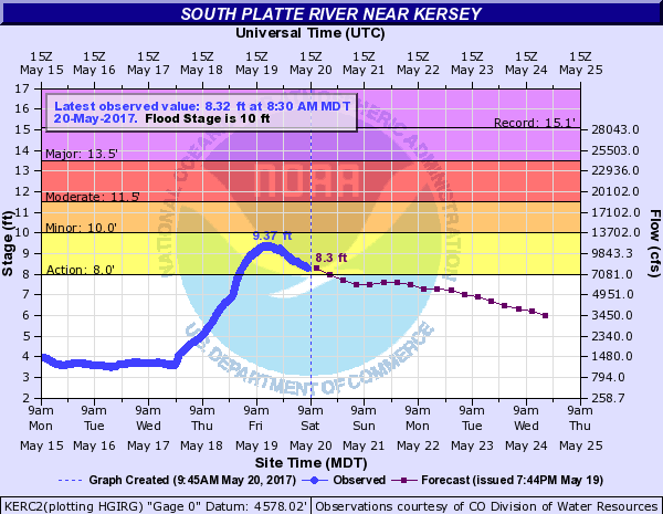
The main riverine flooding concern was on the South Platte River, especially around the confluence with the Cache la Poudre. The flood crest occurred in that area on Friday and levels will continue to slowly recede, though this will be mitigated by melting snow over the next few days. Below is a hydrograph from the Kersey gauge that captures the entirety of the storm event.

For precipitation estimates in your area, check out our Precipitation Map below. Flooding was not reported on Friday.

Storm Total Precip Legend

STP 05-19-2017: Late Season Snowstorm Causes Widespread Precipitation Along With Major Snow Dump

Issue Date: Friday, May 19th, 2017
Issue Time: 11:00AM MDT

Summary:

A strong disturbance and associate low-pressure system affected most of Colorado on Thursday, bringing multiple waves of showers, along with heavy snow in the mountains (and lower elevations for a time), and a few thunderstorms. The highest 24-hour precipitation amounts occurred in the Front Range and Urban Corridor, roughly along the I-25 corridor from Boulder to the Wyoming state line. These regions are typically favored for easterly upslope flow events as yesterday’s storm was. A short list of highest amounts include:

3.82 inches in Larimer County
3.26 inches in Weld County
2.49 inches in Boulder County
1.82 inches in Jefferson County
1.71 inches in Gilpin County

Snow totals for this event were also impressive, especially given how late into the season it was and how low the snow-levels were for most of Thursday. Highest snow amounts were:

30 inches in Larimer County
30 inches in Boulder County
22 inches in Gilpin County
19 inches in Jefferson County
11 inches in Summit County

In addition, thunderstorms producing heavy rainfall were observed across the Southeast Plains as some atmospheric instability developed in conjunction with the strong upper-level forcing. Anywhere between 0.5 to 0.75 inches of rainfall occurred in parts of Pueblo County, likely falling in a period of 1 hour or less.

For precipitation estimates in your area, check out our Precipitation Map below (note that this map is underestimating amounts north of Boulder – an updated map will be provided this afternoon). Flooding was not reported on Thursday.


Storm Total Precip Legend

STP 05-18-2017: Widespread Rain and Snow As Strong Disturbance Approached Colorado

Issue Date: May 18th, 2017
Issue Time: 9:55AM MDT

Summary:

Weather-wise, Wednesday was a day of change across Colorado as a strong disturbance approached the state from the west. West of the Continental Divide, rain and snow showers increased in intensity and coverage as the day wore on. Some impressive snow totals, exceeding 1 foot, were observed, which certainly helps the state’s water supply over the next few months. Precipitation totals west of the Divide generally ranged in the 0.25 to 1.0 inch range.

Heavier rainfall was observed farther east, with the highest amounts falling across the Front Range and Urban Corridor. A moist air boundary moved into northeast Colorado from the northeast and sparked several moderate to strong thunderstorms as it progressed towards the Front Range. The most noteworthy storm was likely near Greeley (Weld County) where over 2 inches of rain fell in less than 3 hours. Elsewhere, several hours of moderate rainfall amounted to over 1 inch of total precipitation across many parts of the Front Range.

For precipitation estimates in your area, check out our Precipitation Map below. Flooding was not reported on Wednesday.

Storm Total Precip Legend

STP 05-17-2017: Upper-Level Trough Supported Numerous Showers/Thunderstorms

Issue Date: Wednesday, May 17th, 2017
Issue Time: 10:10 AM MDT

Summary:

As the upper-level trough rotated through the state, it provided the support for scattered-to-widespread showers and thunderstorms across much of the state. The strongest storms/heaviest rain was focused across eastern Colorado where a few strong-to-severe storms rumbled. According to CoCoRaHS observers, the following were the big winners from yesterday’s rainfall:

Prowers County: 1.30 inches
Washington County: 1.10 inches
Phillips County: 0.94 inches
Kiowa County: 0.87 inches
Logan County: 0.78 inches

For a statewide look at 24-hour precipitation totals, please take a look at the Storm Total Precipitation map below. No flash flooding was observed or reported yesterday.


Storm Total Precip Legend