STP 07-07-2017: Isolated T-Storms Within The Intense Heat

Issue Date: Friday, July 7, 2017
Issue Time: 11AM MDT

Summary:

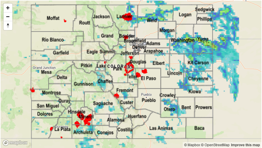
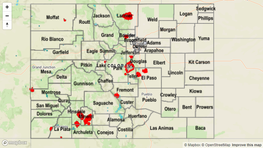
Weak upslope flow helped trigger isolated stronger thunderstorms along the Front Range that impacted the Urban Corridor and Northeast Plains yesterday. Despite the relatively low atmospheric moisture available for storms, there were a couple of impressive totals. Over Fort Collins, there was a large thunderstorm that produced over 1 inch of rain in less than 30 minutes. This storm eventually grew into a storm complex that moved south and eastward causing short term heavy rainfall up to 0.8 inches in 30 minutes.

Where storms did not occur, intense heat was the main story with temperatures continuing their long streak of being above normal. Many locations below 5,000 feet notched high temperatures above 100F.

No flooding was reported yesterday. Please see the STP map below for a look at precipitation totals from the last 24 hours.

Storm Total Precip Legend

STP 07-06-2017: Subsidence Limits Rainfall

Issue Date: Thursday, July 6, 2017
Issue Time: 10:00AM MDT

Summary:

The subsidence associated with the High pressure system limited rainfall to higher terrain yesterday. The highest CoCoRaHS station reported 0.23 inches in Alamosa County. The SNOTEL site at Tower (outside Steamboat Springs) reported 0.5 inches of rain. Radar estimates were 0.6 inches in the small storm cores. There were no storm reports and no flooding occurred yesterday.

Looking back over the month of June, Colorado was warmer than climatology over the majority of the state. West of the Continental Divide, it was up to 6F warmer with Saguache County 6-7F warmer than climatology. As for precipitation, except for the eastern border with KS/NE, the bulk of the state was below normal. The Front Range, Urban Corridor and Northeast Plains were up to 3 inches below normal. A third figure was added to show the percent of normal precipitation. This figure will better put in perspective the anomalies of the total precipitation.


Flooding was not reported on Wednesday. Please see the STP map below for a look at precipitation totals from the last 24 hours.

Storm Total Precip Legend

STP 07-05-2017: A Few Storms Out East Amidst The Heat

Issue Date: Wednesday, July 5th, 2017
Issue Time: 10AM MDT

Summary:

A strong upper-level ridge continued to build over the Great Basin on Independence Day Tuesday, providing hot and mostly dry weather across Colorado. Enough low-level moisture was present across the eastern part of the state to fuel isolated thunderstorms. Brief heavy rainfall was observed with these storms to the tune of (up to) 0.6 inches in 30 minutes. In addition, hail up to 1 inch and gusty winds up to 60 mph were observed, prompting three severe thunderstorm warnings.

Out west, hot and dry weather continued to create conditions favorable for wildfire growth. As of this morning, there are 5 active wildfires going on west of the Continental Divide. We will continue to closely track the burn areas from these fires, especially with a prolonged stretch of rainfall expected to start soon (see the Flood Threat Outlook).

Flooding was not reported on Tuesday. For rainfall estimates in your area, check out the State Precipitation Map below.

Storm Total Precip Legend

STP 07-04-2017: Isolated Showers/Thunderstorms, a Few were Strong/Severe

Issue Date: Tuesday, July 4th, 2017
Issue Time: 10:10 AM MDT

Summary:

Mother Nature provided a few pre-Independence Day fireworks yesterday, with isolated showers/thunderstorms rumbling across the state. Generally speaking, those that occurred over the High Country and adjacent Urban Corridor/Plains, showers/storms produced more wind than rain. Farther east over the Northeast and Southeast Plains, a few strong/severe thunderstorms produced strong winds, hail, and brief periods of moderate-to-heavy rainfall. Rain rates did not meet flash flood criteria, so no flooding occurred. A brief look at storm reports from yesterday shows the following:

Rifle (Garfield County): 45 mph thunderstorm wind gust
Otis (Washington County): 0.88 inch hail
1 mile S of Otis (Washington County): 1.5 inch hail
Flagler (Kit Carson County): 0.9 inches of rain in one hour
6 miles NNE of Bethune (Kit Carson County): 60 mph thunderstorm wind gust
1 mile E of Burlington (Kit Carson County): 69 mph wind gust

Please see the STP map below for a look at precipitation totals from the last 24 hours.

Storm Total Precip Legend