SPM 09-27-2022: Pleasant Fall Monday

Issue Date: Tuesday, September 27th, 2022
Issue Time: 10:50 AM MDT

Summary:

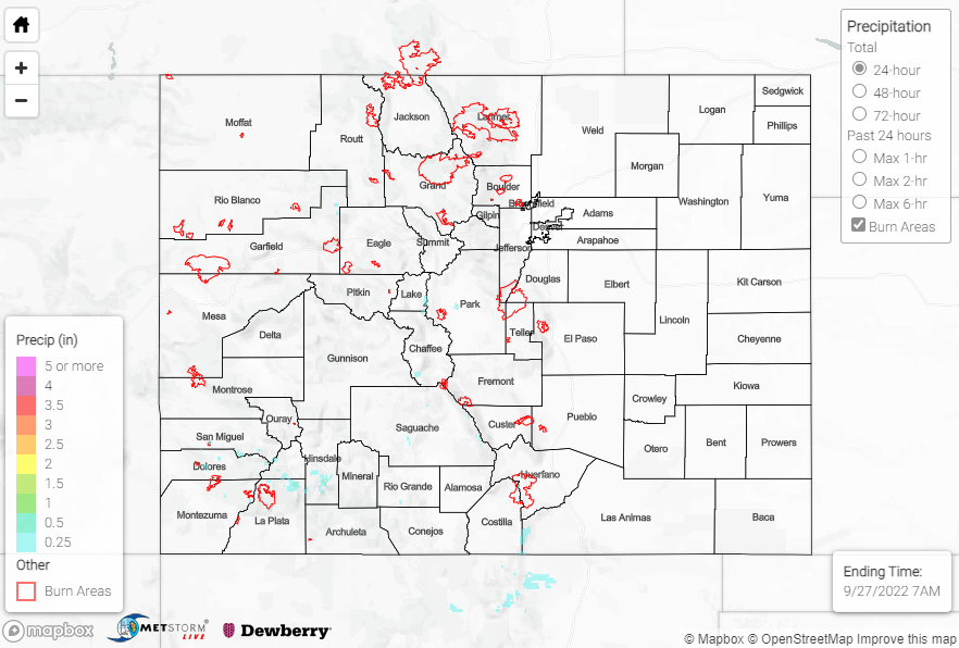
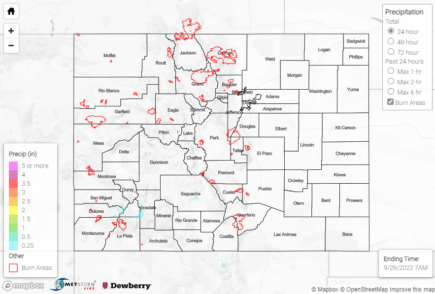
A beautiful fall day greeted most Coloradoans on Monday with clear skies thanks to the continued dominance of the upper-level ridge on our local weather. Slightly increased moisture for southern areas of the state led to isolated showers and storms over the highest elevations of the San Juan and Southeast Mountains once again. Precipitation was only recorded at a handful of mountain stations, with no more than 0.20” observed.

No flooding was reported yesterday. For precipitation estimates in our area, check out the map below. Remember, if you observe flooding in your area, you can use the “Report a Flood” page to make a flood report when you can safely do so.

Click Here For Map Overview

The map below shows radar-estimated, rainfall gage-adjusted Quantitative Precipitation Estimates (QPE) across Colorado. The map is updated daily during the operational season (May 1 – Sep 30) by 11AM. The following six layers are currently available: 24-hour, 48-hour and 72-hour total precipitation, as well as maximum 1-hour, 2-hour and 6-hour precipitation over the past 24 hour period (to estimate where flash flooding may have occurred). The accumulation ending time is 7AM of the date shown in the bottom right corner. Also shown optionally are vulnerable fire burn areas (post 2012), which are updated throughout the season to include new, vulnerable burn areas. The home button in the top left corner resets the map to the original zoom.

SPM 09-26-2022: Pleasant Sunday

Issue Date: Monday, September 26th, 2022
Issue Time: 9:00 AM MDT

Summary:

The Boulder WFO nicely summarized yesterday’s weather in a single tweet:

Pleasant temperatures and clear skies prevailed across the state on Sunday. The only exception was across the highest terrain of the southern San Juan and Southeast Mountains, where isolated weak showers and storms popped up during the late afternoon; only a handful of stations reported measurable precipitation, recording no more than 0.10”.

No flooding was reported yesterday. For precipitation estimates in our area, check out the map below. Remember, if you observe flooding in your area, you can use the “Report a Flood” page to make a flood report when you can safely do so.

Click Here For Map Overview

The map below shows radar-estimated, rainfall gage-adjusted Quantitative Precipitation Estimates (QPE) across Colorado. The map is updated daily during the operational season (May 1 – Sep 30) by 11AM. The following six layers are currently available: 24-hour, 48-hour and 72-hour total precipitation, as well as maximum 1-hour, 2-hour and 6-hour precipitation over the past 24 hour period (to estimate where flash flooding may have occurred). The accumulation ending time is 7AM of the date shown in the bottom right corner. Also shown optionally are vulnerable fire burn areas (post 2012), which are updated throughout the season to include new, vulnerable burn areas. The home button in the top left corner resets the map to the original zoom.

SPM 09-25-2022: Quiet Weather Continues

Issue Date: Sunday, September 25th, 2022
Issue Time: 9:30 AM MDT

Summary:

The ridge of high pressure continued building over Colorado on Saturday, bringing with it clear skies and another day of dry weather. Winds were breezy, but no precipitation was observed, making for an all-in-all pleasant early fall day.

No flooding was reported yesterday. For precipitation estimates in our area, check out the map below. Remember, if you observe flooding in your area, you can use the “Report a Flood” page to make a flood report when you can safely do so.

Click Here For Map Overview

The map below shows radar-estimated, rainfall gage-adjusted Quantitative Precipitation Estimates (QPE) across Colorado. The map is updated daily during the operational season (May 1 – Sep 30) by 11AM. The following six layers are currently available: 24-hour, 48-hour and 72-hour total precipitation, as well as maximum 1-hour, 2-hour and 6-hour precipitation over the past 24 hour period (to estimate where flash flooding may have occurred). The accumulation ending time is 7AM of the date shown in the bottom right corner. Also shown optionally are vulnerable fire burn areas (post 2012), which are updated throughout the season to include new, vulnerable burn areas. The home button in the top left corner resets the map to the original zoom.

SPM 09-24-2022: Skies Clear, Dry Friday

Issue Date: Saturday, September 24th, 2022
Issue Time: 9:30 AM MDT

Summary:

High pressure moved into Colorado from the west on Friday, scouring out residual moisture from the late-season monsoonal event of the last few days. The influx of dry air helped to erode cloud cover and brought clear skies, fair conditions, and gusty winds statewide. Aside from a handful of isolated stations reporting T-0.03”, no precipitation was observed.

Check out these awesome shots of the first signs of fall near Telluride:

No flooding was reported yesterday. For precipitation estimates in our area, check out the map below. Remember, if you observe flooding in your area, you can use the “Report a Flood” page to make a flood report when you can safely do so.

Click Here For Map Overview

The map below shows radar-estimated, rainfall gage-adjusted Quantitative Precipitation Estimates (QPE) across Colorado. The map is updated daily during the operational season (May 1 – Sep 30) by 11AM. The following six layers are currently available: 24-hour, 48-hour and 72-hour total precipitation, as well as maximum 1-hour, 2-hour and 6-hour precipitation over the past 24 hour period (to estimate where flash flooding may have occurred). The accumulation ending time is 7AM of the date shown in the bottom right corner. Also shown optionally are vulnerable fire burn areas (post 2012), which are updated throughout the season to include new, vulnerable burn areas. The home button in the top left corner resets the map to the original zoom.