SPM 05-12-2020: Widespread Rainfall with a Couple Thunderstorms & Snow for the Highest Elevations

Issue Date: Tuesday, May 12th, 2020
Issue Time: 9:20AM MDT

Summary:

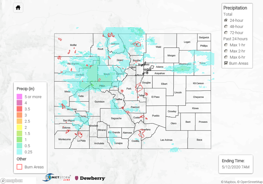
Active weather day across the state that began with rainfall over western Colorado Sunday night into Monday morning. This system moved east throughout the morning and produced abundant cloud cover over the state. Behind the system, there was a bit of clearing, which allow for some thunderstorms to develop over western Colorado (increased instability). Hail was reported with these storms that varied in size from 0.25 inches to 1.25 inches. A stronger storm in eastern Mesa County and western Pitkin County helped produce 24-hour totals around 1 inch with the multiple rounds of showers. Thankfully, rainfall was gradual enough that it didn’t cause flooding issues over the Lake Christine burn area. Several reports from CoCoRaHS stations were over 1 inch, but the Roaring Fork gage at Glenwood Springs saw only about a 0.5 feet increase in gage height. Strong winds were also reported in the range of 46 to 63 mph. Leadville reported 1.5 inches of snow, which sits at 10,151 feet, so not too surprising. Rainfall was more stratiform over eastern Colorado with 24-hour totals up to 0.5 inches in southern Washington County. Unfortunately, the areas experiencing extreme drought received the least amount of precipitation.

For precipitation estimates in your area over the last 24-hours, scroll down to the State Precipitation Map below.

Click Here For Map Overview

The map below shows radar-estimated, rainfall gage-adjusted Quantitative Precipitation Estimates (QPE) across Colorado. The map is updated daily during the operational season (May 1 – Sep 30) by 11AM. The following six layers are currently available: 24-hour, 48-hour and 72-hour total precipitation, as well as maximum 1-hour, 2-hour and 6-hour precipitation over the past 24 hour period (to estimate where flash flooding may have occurred). The 24-hour, 48-hour and 72-hour total precipitation contain bias corrections that are not disaggregated into the hourly estimates, so there will likely be some differences. The accumulation ending time is 7AM of the date shown in the bottom right corner. Also shown optionally are vulnerable fire burn areas (post 2012), which are updated throughout the season to include new, vulnerable burn areas. The home button in the top left corner resets the map to the original zoom.

SPM 05-11-2020: Moisture Begins to Arrive from the South Sparking High-Based Storms

Issue Date: Monday, May 11th, 2020
Issue Time: 10AM MDT

Summary:

A shortwave trough helped push the ridge slightly east to help pull moisture up from the south over western Colorado. This triggered some high based storms and showers yesterday afternoon that continued overnight. The low levels were still quite dry, which limited the accumulations. Overall, less than 0.1 inches fell across the Grand Valley, Central/San Juan Mountains and Southwest Slope. There were a couple spots in eastern Montrose, Mesa and Pitkin county that received 0.25 inches according to CoCoRaHS in the area. Several CoCoRaHS reported at least some rainfall in the region. Looking for that moisture to increase this afternoon for more wetting rainfall. Flooding was not reported on Sunday.

For precipitation estimates in your neighborhood over the last 24-hours, scroll down to the State Precipitation Map below.

Click Here For Map Overview

The map below shows radar-estimated, rainfall gage-adjusted Quantitative Precipitation Estimates (QPE) across Colorado. The map is updated daily during the operational season (May 1 – Sep 30) by 11AM. The following six layers are currently available: 24-hour, 48-hour and 72-hour total precipitation, as well as maximum 1-hour, 2-hour and 6-hour precipitation over the past 24 hour period (to estimate where flash flooding may have occurred). The 24-hour, 48-hour and 72-hour total precipitation contain bias corrections that are not disaggregated into the hourly estimates, so there will likely be some differences. The accumulation ending time is 7AM of the date shown in the bottom right corner. Also shown optionally are vulnerable fire burn areas (post 2012), which are updated throughout the season to include new, vulnerable burn areas. The home button in the top left corner resets the map to the original zoom.

SPM 05-10-2020: Plenty of Sunshine West, Mix of Sun and Clouds East

Issue Date: Sunday, May 10th, 2020
Issue Time: 9:00 AM MDT

Summary:

Plenty of sunshine to be enjoyed across Colorado yesterday, especially west of the Continental Divide where dry air and blue skies ruled the day. East of the Divide, skies began mostly sunny with clouds increasing through the afternoon downstream of the Front Range and Southeast Mountains. That cloud deck continued to hang on into the morning hours today across portions of the Northeast Plains, which helped to keep temperatures a bit warmer than expected overnight, reducing the risk of frost for locations near the CO/NE border.

Flooding was not reported on Saturday. For rainfall estimates in your area, check out our State Precipitation Map below.

Click Here For Map Overview

The map below shows radar-estimated, rainfall gage-adjusted Quantitative Precipitation Estimates (QPE) across Colorado. The map is updated daily during the operational season (May 1 – Sep 30) by 11AM. The following six layers are currently available: 24-hour, 48-hour and 72-hour total precipitation, as well as maximum 1-hour, 2-hour and 6-hour precipitation over the past 24 hour period (to estimate where flash flooding may have occurred). The 24-hour, 48-hour and 72-hour total precipitation contain bias corrections that are not disaggregated into the hourly estimates, so there will likely be some differences. The accumulation ending time is 7AM of the date shown in the bottom right corner. Also shown optionally are vulnerable fire burn areas (post 2012), which are updated throughout the season to include new, vulnerable burn areas. The home button in the top left corner resets the map to the original zoom.

SPM 05-09-2020: Plenty of Sunshine, a Few Sprinkles Overnight

Issue Date: Saturday, May 9th, 2020
Issue Time: 9:00 AM MDT

Summary:

Behind a cool front that gusted through the state late Thursday/early Friday, temperatures across the state yesterday were slightly cooler than normal. Dry air aloft allowed blue skies to return for the afternoon and evening hours; however, a weak disturbance and surface cool front slid across northern Colorado during the overnight hours, resulting in mainly scattered clouds over the Northern Mountains, Front Range, northern Urban Corridor, and Northeast Plains, with a few light sprinkles mixed in.

Flooding was not reported on Saturday. For rainfall estimates in your area, check out our State Precipitation Map below.

Click Here For Map Overview

The map below shows radar-estimated, rainfall gage-adjusted Quantitative Precipitation Estimates (QPE) across Colorado. The map is updated daily during the operational season (May 1 – Sep 30) by 11AM. The following six layers are currently available: 24-hour, 48-hour and 72-hour total precipitation, as well as maximum 1-hour, 2-hour and 6-hour precipitation over the past 24 hour period (to estimate where flash flooding may have occurred). The 24-hour, 48-hour and 72-hour total precipitation contain bias corrections that are not disaggregated into the hourly estimates, so there will likely be some differences. The accumulation ending time is 7AM of the date shown in the bottom right corner. Also shown optionally are vulnerable fire burn areas (post 2012), which are updated throughout the season to include new, vulnerable burn areas. The home button in the top left corner resets the map to the original zoom.