FTO 07-21-2022: Heavy Rainfall Threat Increases This Weekend Into Next Week; High Threat Issued

Issue Date: Thursday, July 21st, 2022
Issue Time: 2:20PM MDT
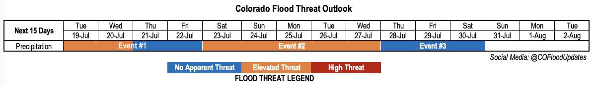
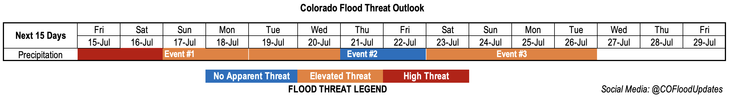
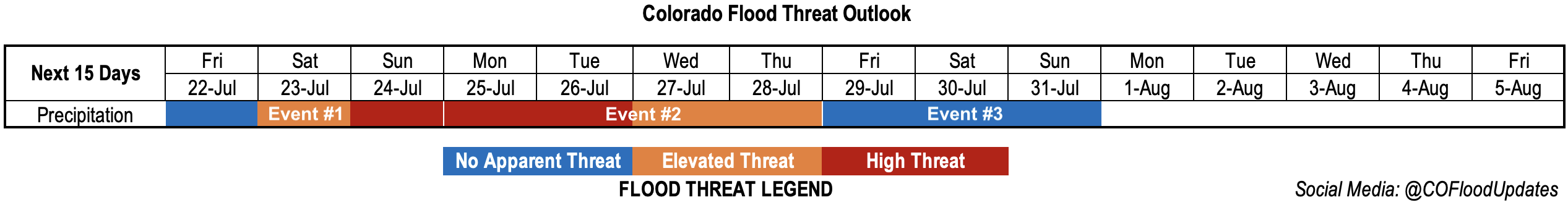
Valid Dates: 7/22 – 8/5

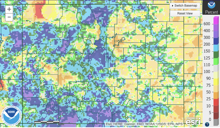
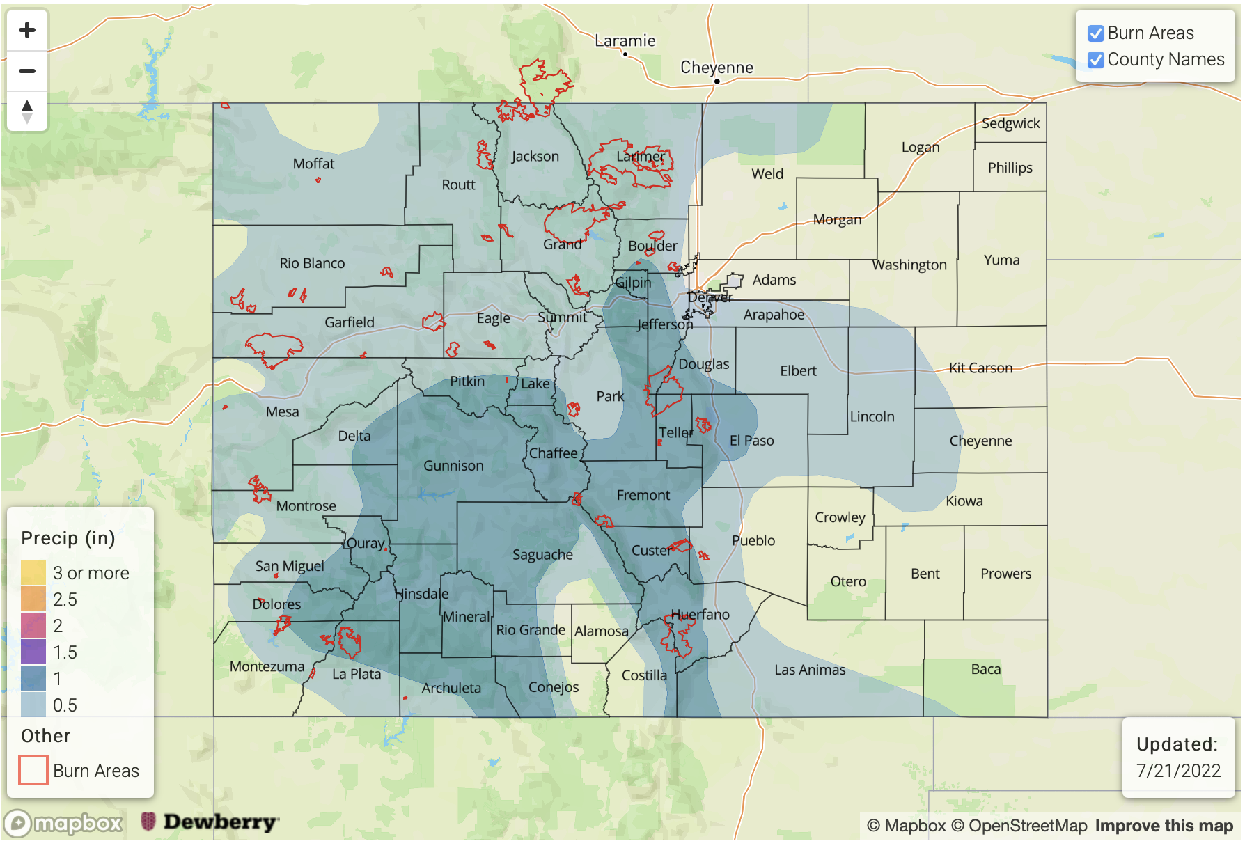
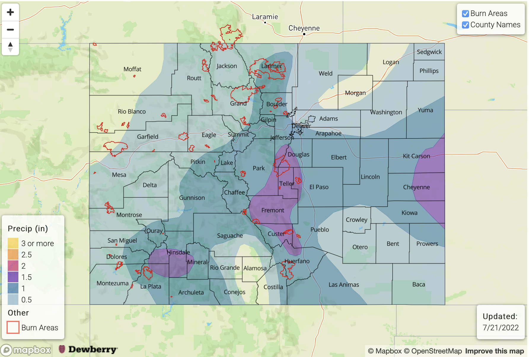
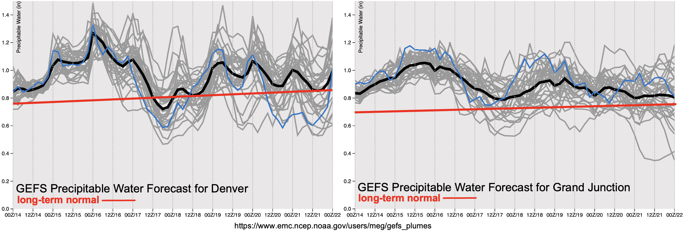
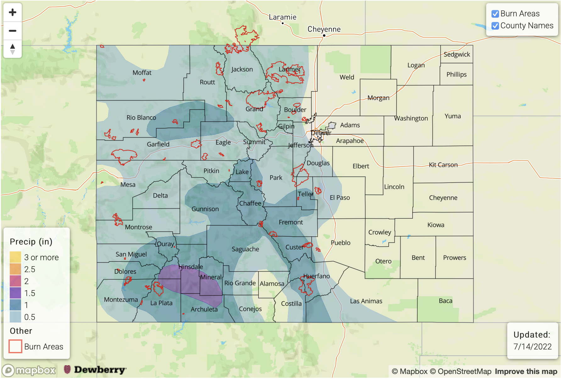
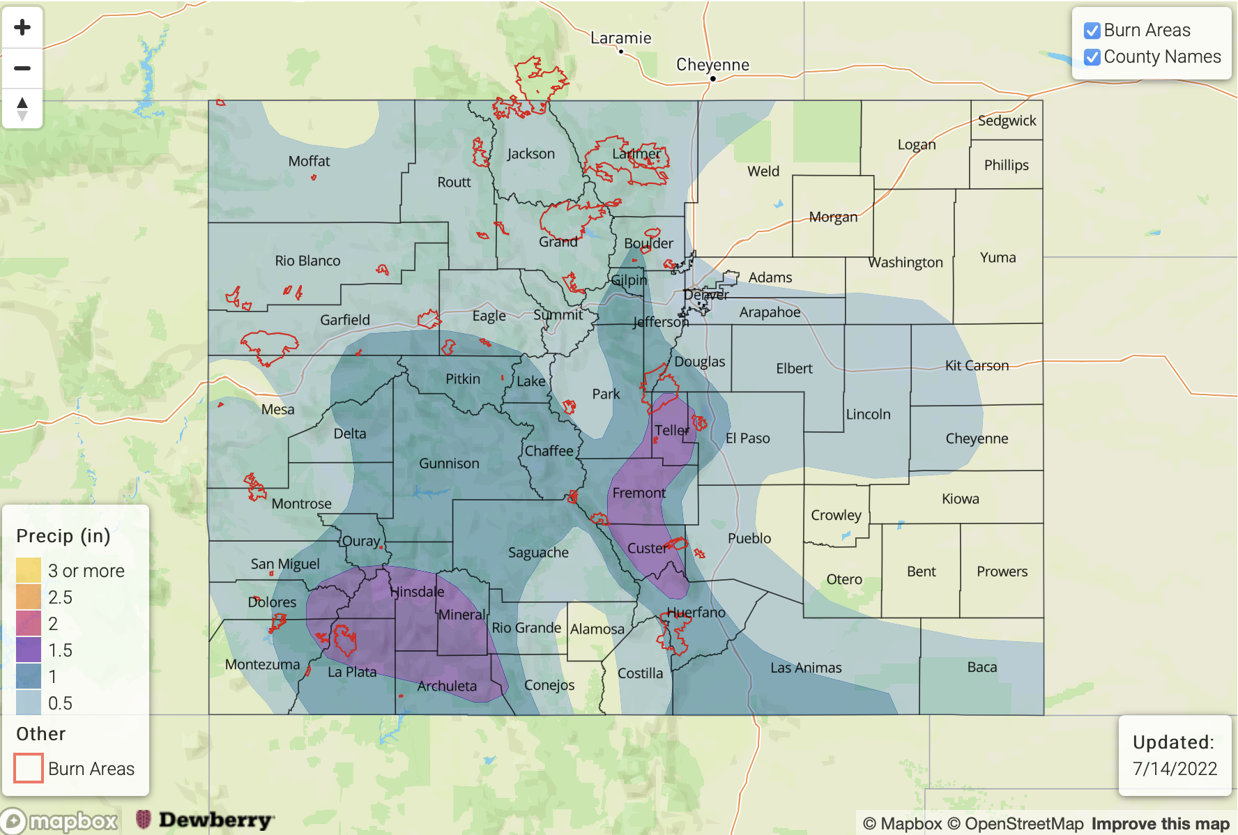
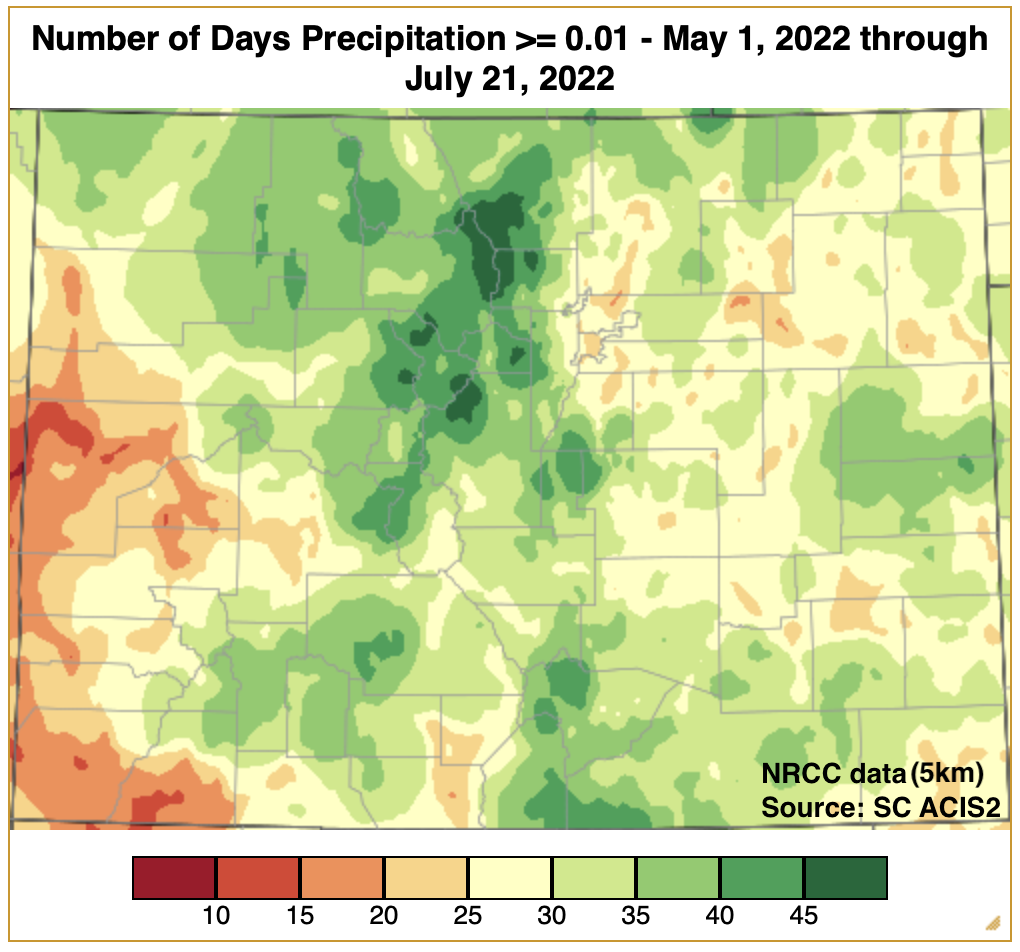
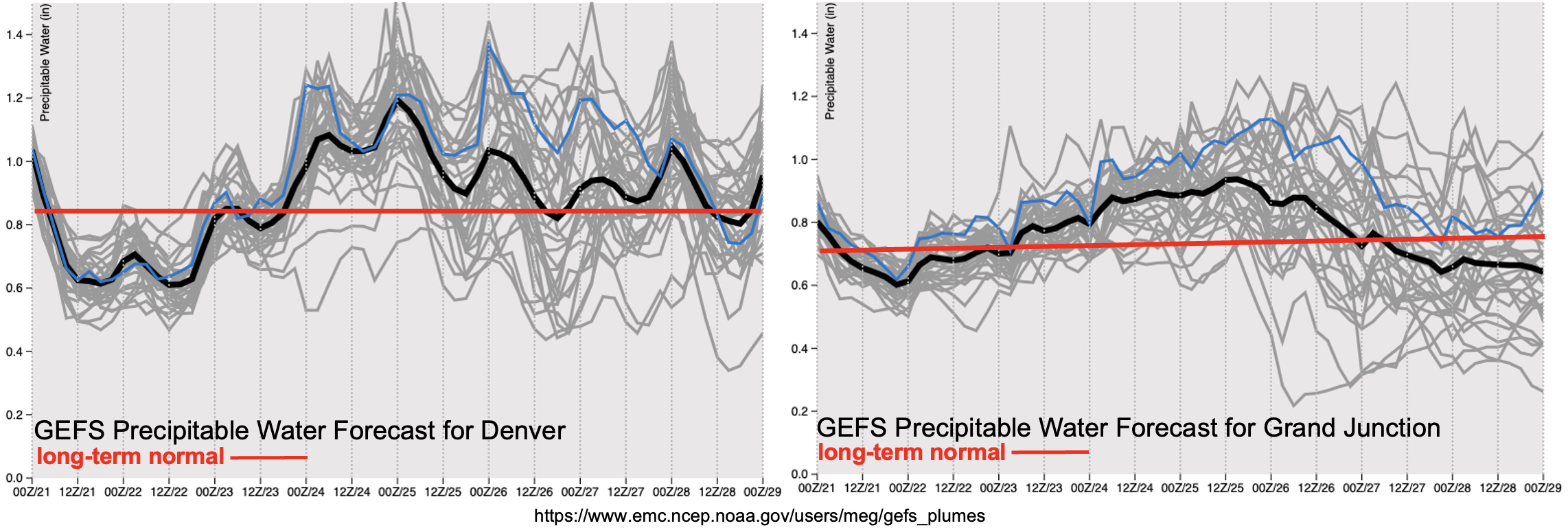
Before we get going with today’s FTO, here’s a quick look at the estimated number of precipitation days across the state since May 1st. For reference, it has been 81 days or slightly over halfway through the FTB forecast season. It has been very active along the Front Range and Central Mountains, especially near the Continental Divide. The Grand Valley and Northwest Slope have also been more active than last year, but more limited precipitation days were noted over the elevated ridges and eastern plains. Overall, it has been a long and active monsoon season for the higher terrains, and it sure isn’t going to stop for this next FTO period. This is right on time with the peak in climatological PW for the year.

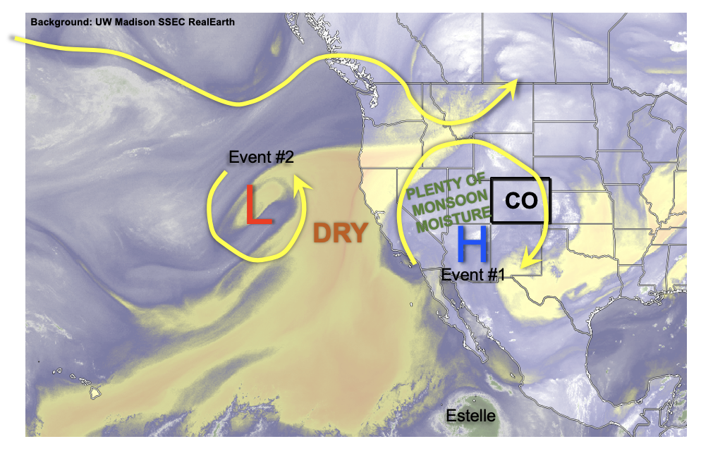
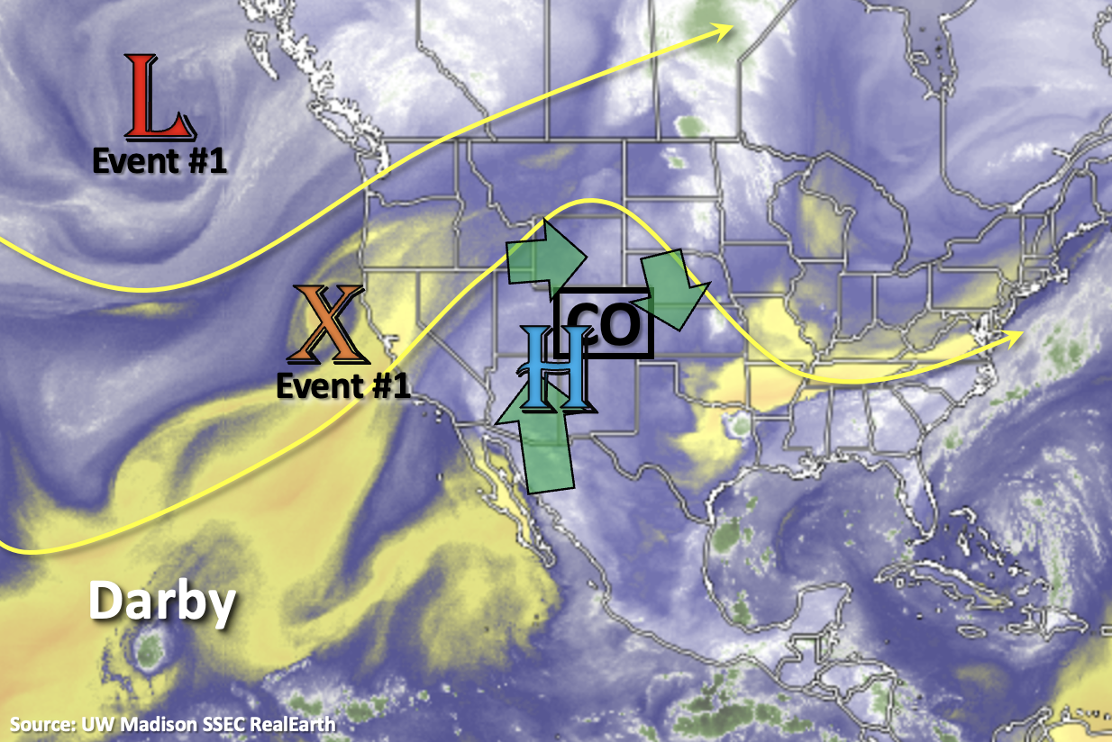
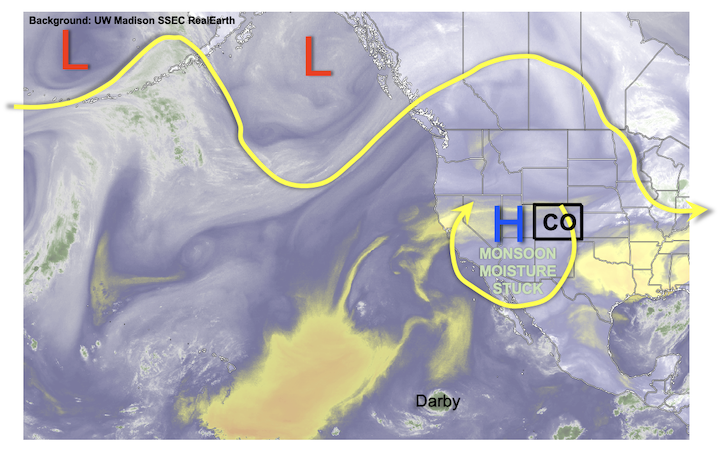
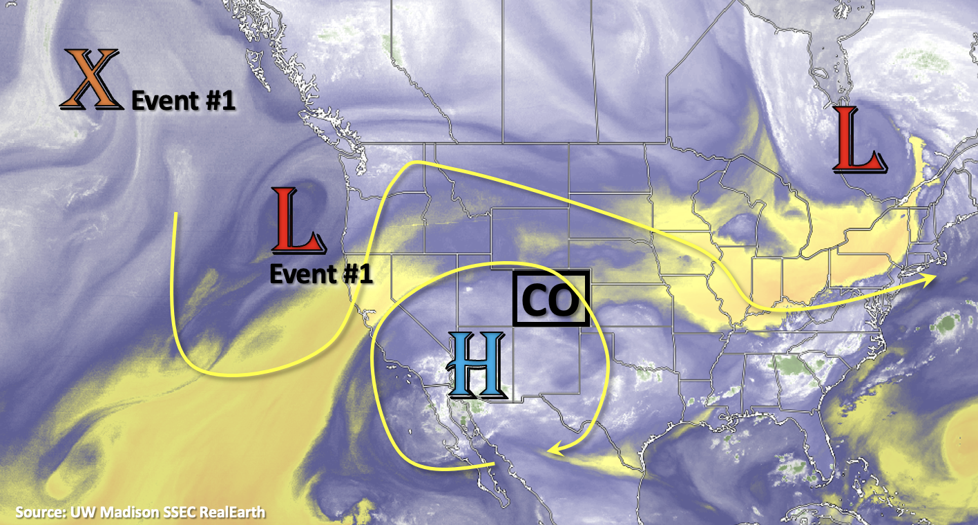
Looking at the water vapor imagery below, the High is currently over Arizona with an incoming Low off the west coast. As the Low and subsequent shortwaves move east over the next few days (Event #1), they will start to break down the High before a ridge rebuilds over the Pacific (Event #2). A second High should then develop to our southeast, which will help pull a subtropical moisture plume northward on its west side. As this moisture meets disturbances moving through the northwesterly flow, a very active rainfall pattern is anticipated. Finally, by the end of next week, the High should begin to reestablish itself over the Four Corners region. This should keep rainfall in the forecast for the foreseeable future.

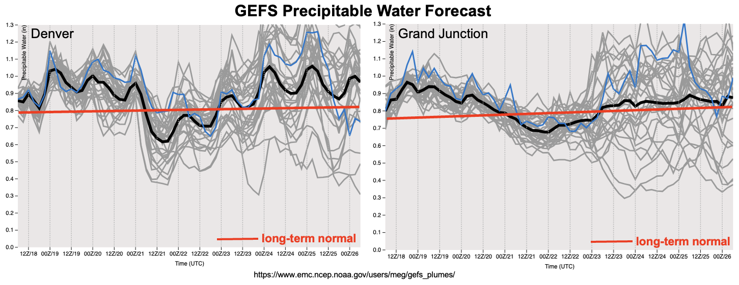
As far as the flood threat, after tomorrow, it becomes quite elevated with PW at or above the long-term average through Tuesday (west) and Thursday (east). A High flood threat has been issued for Sunday through Tuesday with a peak in rainfall activity (intensity and coverage) anticipated on Sunday. An Elevated threat has then been issued for the back end of Event #2, but it is possible that this could be upgraded in Monday’s FTO. At that time, there should be better model consensus about where the moisture plume will set up, but it is likely that the heavy rainfall threat will continue over eastern Colorado. The end of Event #2 should be the most favorable pattern for widespread rainfall over the eastern plains.

One other weather factor for the end of this week will be the continuation of heat on Friday and Saturday. A Heat Advisory has been issued for the Grand Valley tomorrow with a shot at breaking the Grand Junction daily record. A high temperature of 104°F has been forecast with upper 90Fs forecast across the I-25 Corridor. On Saturday, there will be another shot at breaking the Grand Junction daily record as well as the daily records over Alamosa and Pueblo. High temperatures over the eastern plains should reach between 100-105°F, so be sure to hydrate over the next couple of days. A cooldown is anticipated on Sunday with a shot at much cooler temperatures for eastern Colorado on Wednesday behind a strong cold front.

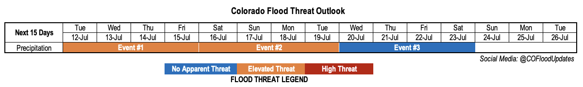
Event #1: Friday – Sunday (7/22 – 7/24)

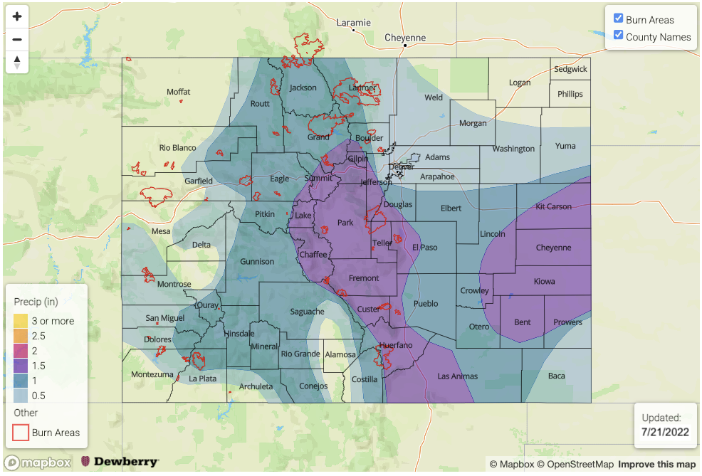
There is an increasing threat for this event with a High flood threat issued on Sunday as an abundance of moisture and mid-level dynamics combine for widespread, heavy rainfall.

More garden variety storms are forecast tomorrow with residual moisture over the area. Best chance for isolated to widely scattered storms will again be across the high terrains favoring areas south with some limited activity possible over the far eastern plains. There should be an uptick in moisture and dynamics on Saturday with scattered storms forecast over the mountains. With steering flows increasing across the northern portion of the state, the flood threat should be limited to the burn areas for this area. Over the central and southern high terrains slower steering flows and some training storms could produce isolated heavy rainfall with max 1-hour rain rates up to 1.1 inches possible. Sunday is the peak in rainfall intensity and coverage for this event with activity ramping up due to a passing shortwave and westerly steering flows spilling storms into the adjacent eastern plains. Max 1-hour rain rates up to 1.5 inches (west) and 2.25 inches (east) will be possible along with a couple stronger thunderstorms. A HIGH flood threat has been issued for this day as a Moderate threat or higher will likely be issued in the daily FTB.
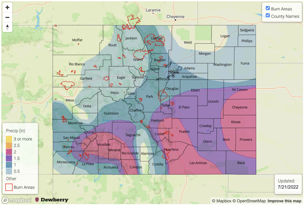
Event #2: MondayThursday (7/25 – 7/28)

High flood threat as moisture streams in from the south with embedded disturbances in the mid-levels.

Heavy rainfall chances continue at the beginning of next week starting out over the southern high terrains. Best chance for heavy rainfall on Monday will be over southwest Colorado, but ongoing rainfall and cloud cover may help to limit the flood threat over the same area on Tuesday. Storm activity looks to increase over eastern Colorado on Wednesday and Thursday with some heavy rainfall forecast for the elevated ridges and Southeast Plains. Hopefully a storm can dip into the Northeast Plains off the Cheyenne Ridge during this period, with this most likely to occur on Wednesday.

Event #3: FridaySunday (7/29 – 7/31)

No Apparent flood threat as High sets back up over the Four Corners region.

A lot of changes are anticipated for Event #3, since it is over a week out before it begins. It looks like the center of the High will set back up over the Four Corners region, which could help produce a rainfall pattern similar to this week. Of course, minor details in the location of the High can be favorable or unfavorable regarding moisture over the state. Likely this will be a mountain rainfall event with minimal spillover into the adjacent eastern plains. Check back in on Monday when the FTO will be updated again.

FTO 07-18-2022: Continuous Above Normal Moisture To Keep Storm Chances Elevated

Issue Date: Monday, July 18th, 2022
Issue Time: 3PM MDT
Valid Dates: 7/19 – 8/2

This summer has been an excellent example of how our unique terrain can “drive” its own circulation to produce heavy rainfall. But the most important ingredient required to accomplish this (much more important than in other parts of the country) is moisture. Moisture over the past ~30 days has been well above normal, both measured by PW over the total atmospheric column as well as in the boundary layer (measured by dewpoint temperature or low-level specific humidity). Yet, as shown below, if we look at total 30-day estimated rainfall departure as a percent of normal, it is clear that not everyone has benefited equally. More specifically, if we focus on areas that have received above normal rainfall, it is well correlated with elevation: higher areas have received much more than lower elevations. Although this is the case climatologically speaking, it is being significantly accentuated this summer.

As we look at the water vapor image, below, it looks like this Outlook will feature a similar story: plenty of moisture along with a favorable monsoonal flow will continue to fuel daily afternoon and evening storm chances. However, they will likely be limited to the higher terrain (though an interesting setup next week may provide some much needed rain to the Northeast and Southeast Plains).

As we see in the forecast PW plumes, below, note that the climatological averages (the red lines) are becoming nearly horizontal as we are finally approaching our highest expected moisture content over the entire year over the next 1-2 weeks! What we also note is that moisture will continue to run above normal levels for basically the entirety of this Outlook. This is occurring because of a favorable position of the upper-level monsoon ridge that will stay generally east of Colorado over the next 7-10 days. This promotes some southerly flow that is able to transport higher moisture from the moisture-rich monsoon hotspot of western Mexico.

Over the course of this week, we will see daily afternoon and evening storms mainly confined to the central higher terrain (Event #1), though there will likely be a brief downtick in storm coverage by Thursday and Friday. However, by Saturday, another strong push of monsoonal moisture will increase storm coverage and promote higher rainfall intensity. An Elevated flood threat is expected at least over the higher terrain. By early next week, things are looking a bit more interesting for areas further east as a cool front may drop southward and coincide with the monsoonal moisture. This type of setup could produce heavy rainfall chances statewide. If model trends continue to show this setup, there could be an upgrade to a High threat in the next Outlook.

The identified precipitation events are described in more detail below.

Event #1: Tuesday – Friday (July 19 – July 22)

Low-end Elevated Flood Threat For Mainly Central Higher Terrain Through Wednesday, Then Rain Chances Decrease Temporarily

Scattered showers and storms are expected over mainly the central and southern higher terrain Tuesday through Friday. The highest coverage will be Tuesday and Wednesday, and max 30 and 60 minute rain rates exceeding 0.8 and 1.2 inches, respectively, will be possible warranting the Elevated flood threat. With a bit less moisture by Thursday and Friday, coverage will follow suit and a flood threat looks unlikely at this time.

Event #2: Saturday – Wednesday (July 23 – July 27)

Elevated Flood Threat First Over Higher Terrain, Then Possibly Over Plains; Upgrade To High Threat Possible

An increase in moisture will increase rainfall coverage and intensity by Saturday, starting mainly with the southwest and western higher terrain, then spreading eastward by Sunday. Max 1-hour rain rates exceeding 1.4 inches look likely, warranting an Elevated flood threat. By Monday and Tuesday, the approach of a cool front could provide additional dynamics to create a threat at the 3-6 hour duration (and upgrade to High flood threat) over the eastern Plains. However, even outside of that occurring, isolated heavy rainfall is expected along and east of the Continental Divide with max 1-hour rain rates likely exceeding 1.0 inch.

Event #3: Thursday – Saturday (July 28 – July 30)

No Apparent Flood Threat But Sufficient Should Keep Storms Around, At Least For Higher Terrain

Moisture should drop off notably after Event #2. However, it will continue to stay near seasonal normal. Isolated to widely scattered storms are expected over the climatologically preferred central and southern higher terrain. But there is No Apparent flood threat at this time.

FTO 07-14-2022: Summer Heat & Rainfall Chances Continue With Another Monsoon Surge Forecast

Issue Date: Thursday, July 14th, 2022
Issue Time: 2PM MDT
Valid Dates: 7/15 – 7/29

As mentioned on Monday, it looks like it’s going to stay active on the rainfall front through the entirety of this outlook, which nearly goes to the end of July. The water vapor imagery (below) shows the subtropical High still located over the Four Corners region. It should continue to hang around this area through Event #3 with some slight north and south movement anticipated as it ebbs and flows in strength. Currently, it is pulling strong subtropical moisture northwards over western Colorado and Utah. As a small disturbance (orange “X”) begins to move inland tomorrow, and the subtropical moisture plume will be transported northward and then eastward around the High through Saturday (green arrows).

This will put PW well above average (see plumes below), and with some extra mid-level energy helping to provide lift and strong upslope flow forecast, an upgrade to a High flood threat has been issued for Friday and Saturday. Reminder that a High threat in the FTO corresponds to a Moderate threat or higher likely being issued in the daily FTB. Behind the passage of the mid-level disturbance on Sunday, there is a slight downtick in moisture, so rainfall is expected to do the same. However, with PW still at or near average, an Elevated flood threat has been issued for the southern and central high terrains.

The stubborn High sticks around through the end of the weekend into early next week before another Low moves east, north of Colorado’s border. This ridge is expected to support hot afternoon temperatures with the highest temperature anomalies are forecast over eastern Colorado where afternoon cloud cover and precipitation will be less likely to occur. The location of the High during this period should help to hold a nice PW plume overhead. While steering flows will be a bit faster next week, PW values should remain around average, keeping an Elevated flood threat for the near term. There will likely be a lull in precipitation at the end of the week before it looks like another monsoon surge will occur over the weekend. More details about each event can be found below.

The NCEI monthly temperature and precipitation rankings have arrived for June. As you would guess, average temperatures across the state were above average with a ranking of 105 (POR 1895-2022), and southwest Colorado received much above average temperatures. As discussed in previous FTO’s, it was a very wet June for southwest Colorado with much above average precipitation recorded. However, both Sedgwick and Phillips County were much below average in terms of rainfall with the majority of the Northeast Plains also below average. As a whole for rainfall, the state ranked 72, which is near average. Below is a look at the latest drought map on the right with drought conditions at the beginning of June on the left. Overall, there has been improvements to the Extreme and Exceptional drought conditions across the southern border over the last month or so, but an increase in extreme drought for the northeast border counties where it was extra dry during June. With precipitation mostly sticking to the mountains over the next week or so, it is likely there won’t be much relief for eastern plains. However, there is an outside chance for some scattered rainfall over the far Northeast Plains during the evening hours if storms can make their way off the Cheyenne Ridge and cross the border tomorrow.

Lastly, the monthly streamflow tracker will be updated on Monday, since we’re still waiting for a lot of the data to come in.

Event #1: Friday – Monday (7/15 – 7/18)

High/Elevated flood threat as monsoon moisture combines with mid-level energy and slower steering flows under the ridge.

An uptick in storms activity and coverage is forecast for tomorrow and Saturday with the passing shortwave and monsoon moisture over the area. Max 1-hour rain rates up to 1.5 inches will be possible over the Central Mountains, Northern Mountains and Front Range on Friday with the threat likely shifting further south over the high terrains on Saturday. A couple storms over the far eastern plains are likely during this period with the Northeast Plains favored tomorrow. Flood threats include road flooding, field ponding and isolated mud/debris flows over the steeper terrains. During this period, it is likely that a few severe thunderstorms could develop with the main threats being strong outflow winds and some hail with decent shear over the state. Be sure to tune into the daily FTB, which can better track these threats. A downtick in moisture and lift is forecast on Sunday with the flood threat likely isolated to the southern Central Mountains, San Juan Mountains and perhaps the southern Southeast Mountains. More widespread storms are then forecast on Monday over the mountains as the ridge axis is pushed east/south with the passage of the next Low to our north.

Event #2: TuesdayFriday (7/19 – 7/22)

Elevated/No Apparent flood threat as the ridge breaks down and a cold front returns moisture to eastern and central Colorado.

Elevated moisture remains over the area at the beginning of next week with more westerly flow forecast over the state as the ridge axis is temporarily pushed south. This may allow some storms to reach into the eastern plains on Tuesday. The ridge quickly rebuilds back to the west of Colorado with a day or two break in heavy rainfall chances likely at the end of the week. Faster steering flows are also forecast during this period over northern and central Colorado, which should help limit the flood threat. However, if training storms develop, there could still be a local threat for heavy rainfall.

Event #3: Saturday – Tuesday (7/23 – 7/26)

Elevated flood threat as the robust monsoon season continues and likely pulls another moisture plume into the state.

Uncertainty in the forecast increases after Event #2, but long-range guidance hints at another monsoon surge to begin at the end of next week. An Elevated flood threat has been issued for this reason and due to increased recreation activity anticipated over the weekend. Please tune back into the FTO on Monday as there will likely be changes to the forecast. Due to the uncertainty, no flood map has been drawn.

FTO 07-11-2022: Stubborn Moisture To Hang Around, Fuel Storm Chances

Issue Date: Monday, July 11th, 2022
Issue Time: 3PM MDT
Valid Dates: 7/12 – 7/26

It has now been about one month since Colorado has recorded a statewide dry day. Now, it is true that some locations have benefited far more than others. For example, large parts of southern and southwestern Colorado have gotten 2-3 times their normal rainfall over the last 30 days. But fortunately (and most people will agree, we think), it looks like that wet streak will continue for a majority of this Outlook. As expected and shown below, the rainfall streak has been associated with an abundance of moisture as measured by PW. A long axis of above normal PW can been originating over the western Mexican highlands and stretching northward into mainly southern Colorado.

As shown in the water vapor image and GEFS forecast PW plumes, below, above normal moisture will be the continued feature in our weather through essentially the entirety of this Outlook. With little to no large-scale forcing to speak of, our weather will be driven by (1) the wobbling in strength and position of the upper-level ridge and embedded small-scale disturbances and (2) the degree of boundary layer and total column moisture that will be available for storm formation. All indications are that PW will remain in the 0.7 – 1.3 inch across Colorado over this Outlook. This is quite a bit above normal. Furthermore, boundary layer moisture also appears to plentiful with dewpoint temperatures in the 40s and 50s F across most of the state and exceeding 60F along our eastern border. Unfortunately, with this kind of steady-state pattern, there is less ability to resolve individual events. However, the main takeaway is that there is very likely to be a continuous Elevated flood threat for mainly the southern and central higher terrain through at least early next week. Check back each morning for daily Bulletin updates that will hone in on particular details.

In addition to above normal moisture, we also expect generally above normal temperatures over this Outlook (after today’s brief cooldown for northeast Colorado). However, the degree of heat will be largely determined by cloud cover and precipitation coverage. At this time, the highest probability for sustained heat will be along the eastern border where the lowest precipitation chances are expected.

The identified precipitation events are described in more detail below.

Event #1: Tuesday – Friday (July 12 – July 15)

Elevated Flood Threat As Daily Higher Terrain Storms Will Be Capable Of Heavy Rainfall

With PW running well above seasonal normal, morning sunshine and plenty of boundary layer moisture will fuel scattered to numerous showers and thunderstorms each day. The region with the highest chances is likely to change daily but overall, the best chances of storms will be over the higher terrain of the Central Mountains, San Juan Mountains, Southeast Mountains with possibly some spillover into the Palmer and Raton ridges.

Maximum 30-minute rainfall intensity of 1.0 inch is expected daily, which will be capable of producing isolated flash flooding, debris slides and mud flows.

Event #2: Saturday – Tuesday (July 16 – July 19)

Continued Elevated Flood Threat With Precipitation Chances Also Extending Further East

The overall setup for this event will be similar to Event #1, although guidance suggests an increase in rain chances over the foothills of the Front Range, Palmer Ridge and Raton Ridges possibly associated with weak cool front passage. The primary storm type appears to be short-term convection with localized heavy rainfall of 30-60 minute duration. Maximum 30-min rain intensity of 1.0 inch and 60-min intensity of 1.5 inches looks possible. However, given the anticipated wet soils after Event #1, there could be an enhanced risk of small creek and stream flooding from efficient runoff. Over the course of Events #1 and #2, lucky higher terrain locations could pick up over 4 inches of rainfall!

Event #3: Wednesday – Saturday (July 20 – July 23)

Precipitation Chances Look To Continue But With Uncertainty In Moisture, No Apparent Flood Threat

There is an increase in uncertainty beyond Event #2 with some guidance suggesting a drying atmosphere from the northwest, while other guidance points to a possible influx of moisture. At this time, there is No Apparent Flood threat though at least isolated shower and storm coverage looks likely for Colorado.