FTO 08-10-2017: More Heavy Rainfall In Short Term, Then Big Pattern Change

Issue Date: Thursday, August 10, 2017
Issue Time: 2:20PM MDT
Valid Dates: 8/11-8/25

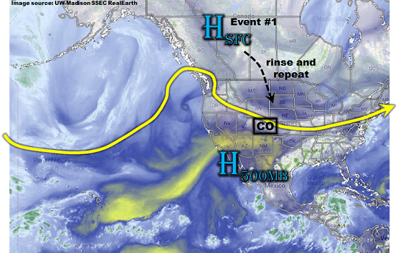
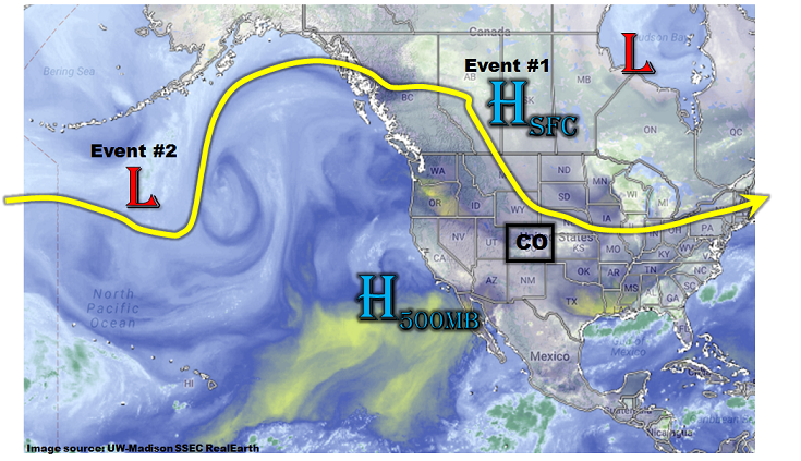
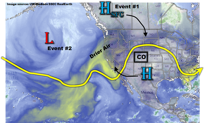
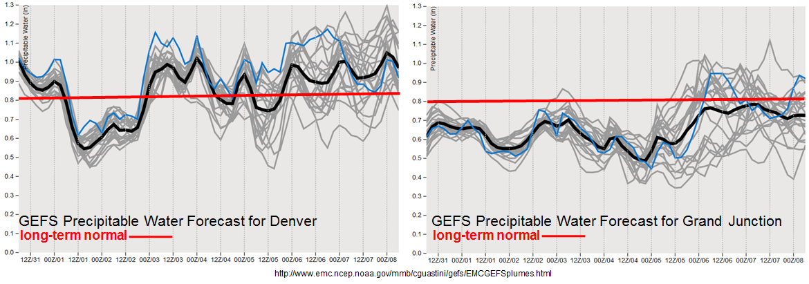
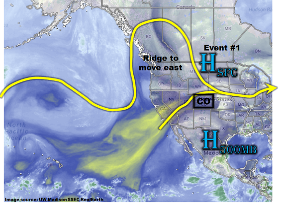
There is finally change towards a drier pattern on the horizon, but not before several more days of heavy rainfall and elevated/high flood threat conditions will be endured. As shown in the northern hemisphere water vapor image, below, a surface high pressure is currently positioned over the northern Great Plains. The clockwise circulation around this high is transporting high moisture into eastern Colorado. At least one more such surface high pressure is expected to move southward over the next 72-120 hours, which will keep elevated moisture in place. Additionally, a strong jet remains overhead, which is supporting relatively cool temperatures at mid-levels (and surface), allowing for daily round of scattered to numerous showers and storms east of the Continental Divide.

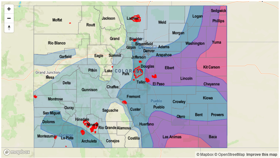
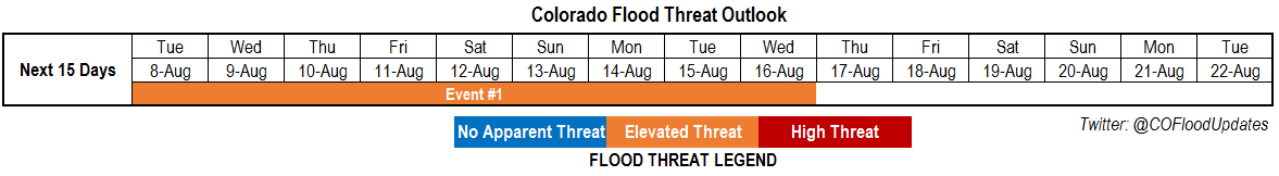
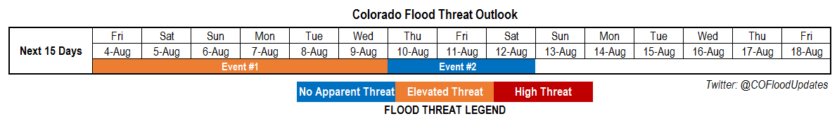
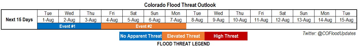
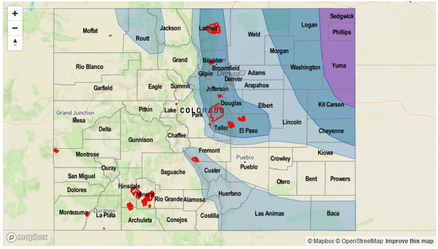
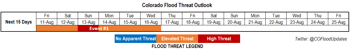
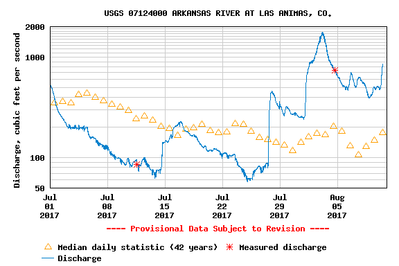
Thus, the prolonged flood threat will continue through early next week, labeled as Event #1 for this Flood Threat Outlook. At this time, it appears that relatively isolated heavy rainfall, and flooding, will be the primary impact. However, the arrival of a new surface boundary on Sunday prompts a High threat, especially given that the region under threat appears to be the Southeast Plains. We cannot overstate the need to monitor the Arkansas River and its tributaries as they remain at elevated levels. The 40 day trace from the Las Animas USGS gage, below, shows that the river has been at significantly elevated levels since late July. Thus, it remains very vulnerable since even modest rainfall and runoff could cause flooding. At this time, we do not expect major riverine flooding within Colorado’s borders, though stay tuned to daily Flood Threat Bulletins for a more detailed look.

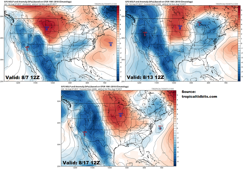
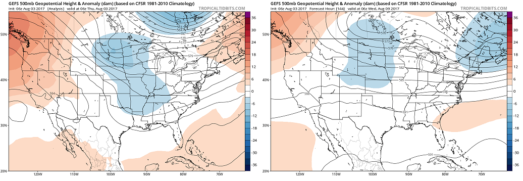
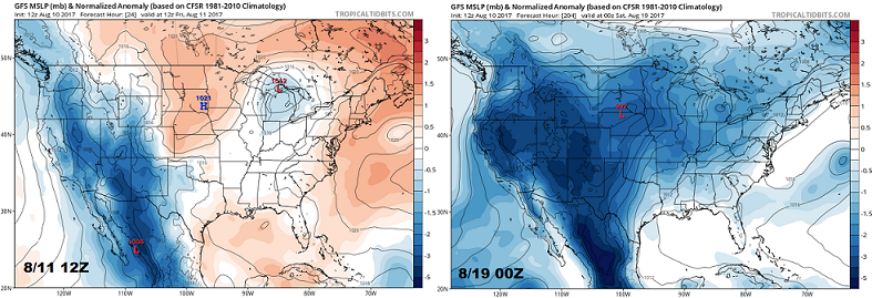
After the middle of next week, we foresee a significant pattern change, as noted by the surface pressure anomaly maps below. Note the high pressure anomalies early in the period, which is supporting the moist easterly flow and heavy rainfall activity. By the middle of next week, a surface low pressure is expected to develop. This means generally downsloping low-level winds, also accompanied by a transport of relatively dry mid-level air from the Great Basin. Thus, we have only identified one precipitation event for this 15-day Outlook, which is described in more detail below.

Event #1: Friday (8/11) through Wednesday (8/16)

Prolonged Elevated/High Flood Threat for daily rounds of heavy rainfall east of the Continental Divide; Arkansas River basin will be vulnerable to minor riverine flooding

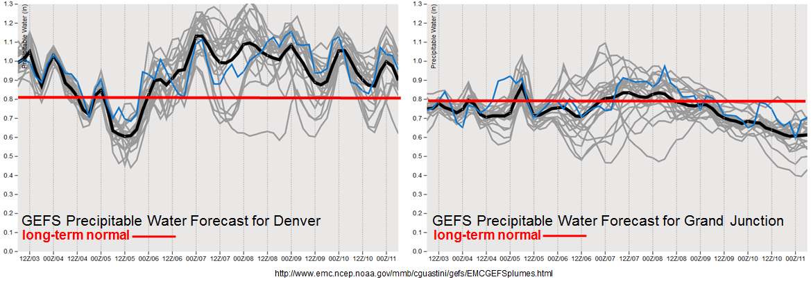
With continued elevated moisture (PW expected to stay at or above 1 inch east of the Continental Divide), daily rounds of scattered to numerous shower and thunderstorm activity are expected. Storms will form off the higher terrain first but then track eastward for at least several hours, especially over the Palmer and Raton Ridges. Max 1-hour rainfall up to 2.4 inches (east) and 1.9 inches (west) will be possible, supporting isolated flash flooding, small stream flooding and street flooding in urban areas. In addition, max 3-hour rainfall up to 3.1 inches (east) and 2.5 inches (west) will support mud flows and debris slides, especially in regions with saturated soils. In addition, the threat of isolated severe weather (mainly large hail) will exist especially towards the Kansas border.

At this moment, Sunday appears to be the most vulnerable day, due to the expected widespread coverage of heavy rainfall in the Southeast Plains. The Arkansas River and its major tributaries will be in a particularly elevated risk of riverine flooding, especially towards the Kansas border.

Legend

FTO 08-07-2017: Relentless Moisture To Keep Fueling Heavy Rainfall

Issue Date: Monday, August 8, 2017
Issue Time: 2:15PM MDT
Valid Dates: 8/8-8/21

As shown in the water vapor image, below, a “rinse and repeat” type pattern is expected over the next 7+ days for this edition of the 15-day Colorado Flood Threat Outlook. Speaking strictly from the perspective of upper-level flow, this pattern is not all that impressive. With a continuation of a modestly strong jet stream positioned just north of Colorado, this time of year, such a pattern would not strike one as being particularly rainy across out state. The big wildcard, however, is the train of surface high pressure systems that will be coming down out of Canada.

This is well depicted in the forecasted sea-level pressure anomaly maps from the Tropical Tidbits website, shown below. The maps show conditions for this afternoon, this coming Sunday (8/13) and next Thursday (8/17). Note the remarkably similar conditions across Colorado and the northern Great Plains as anomalously strong high pressures are forecasted. The implication of such a pattern for our state is two-fold. First, it promotes southeasterly winds that typically allow for access to above normal moisture levels and in turn, heavy rainfall chances. Second, note the relatively strong surface pressure gradients, which allows for an increased amount of moisture convergence. Stated differently, instead of typical high-elevation storms to be “one and done” in the sense that they quickly decay once they move eastward off the higher terrain, storms persist longer and create outflow boundaries. In turn, this supports larger storm complexes where 3-hour and 6-hour windows of heavy rainfall are possible.

However, the pattern described above only favors above normal precipitation east of the Continental Divide. In short, the moisture provided by the surface high pressures cannot readily make it over the Divide. This is readily shown in the forecasted Precipitable Water (PW) plumes from the GFS ensembles. While Denver stays above normal basically the entire next 8 days, Grand Junction drops below normal and stays there. Thus, while we expect some monsoonal moisture and very isolated heavy rainfall to be possible in the climatologically favored southwest areas, the rest of the western slope will be on the drier side.

We have identified one prolonged precipitation event for this Outlook, which is described in more detail below.

Event #1: Tuesday (8/7) through Wednesday (8/16)

Prolonged Elevated Flood Threat for daily rounds of heavy rainfall east of the Continental Divide; Arkansas River basin will be vulnerable to riverine flooding

With Precipitable Water continuing to stay at or above 1 inch east of the Continental Divide, daily rounds of shower and thunderstorm activity are expected. Storms will form off the higher terrain first but then track eastward for at least several hours, especially over the Palmer and Raton Ridges. Max 1-hour rainfall up to 2.4 inches (east) and 1.9 inches (west) will be possible, supporting isolated flash flooding, small stream flooding and street flooding in urban areas. In addition, max 3-hour rainfall up to 3.1 inches (east) and 2.5 inches (west) will support mud flows and debris slides, especially in regions with saturated soils. In addition, the threat of isolated severe weather (mainly large hail) will exist especially towards the Kansas border.

In addition to the short-term hazards described above, we are now more confident that the Arkansas River and its major tributaries (namely: Monument Creek, Fountain Creek, Purgatoire River, Huerfano River, Apishapa River) will be in a prolonged elevated risk of riverine flooding. Current flows in the Arkansas River basin are above the 75th percentile at many locations and saturated soils will promote very efficient runoff. While at this time we expect that any riverine flooding will be short-duration (i.e. peak during late afternoon and subside during the overnight hours), please stay tuned to daily Flood Threat Bulletins as this could change.

Legend

FTO 08-03-2017: Very Active Weather Over The Next 7 Days

Issue Date: Thursday, August 3, 2017
Issue Time: 1PM MDT
Valid Dates: 8/4-8/18

Changes have been, and will continue to be in Colorado’s air for this edition of the 15-day Flood Threat Outlook. As shown in this morning’s water vapor image, below, an upper-level trough has established itself over the northern Great Plains. This has allowed for cool air out of Canada to be transported into eastern Colorado. For example, today’s high temperatures are up to 20F below normal in the northeast part of the state.

As shown in the 500mb GFS ensemble forecast maps, below, this trough is expected to persist not just in the short-term but possibly for the next 7 or more days. Meanwhile, Precipitable Water, while lower today than last week’s impressive string of elevated levels, remains above average. The positioning of the Great Plains trough will allow for a slew of mid-level disturbances to enter Colorado, especially the northeast quadrant of the state. In addition, many of these disturbances will be followed by weak to moderate strength surface high pressure systems such as the one currently moving southward. With some degree of elevated moisture remaining in the state, we foresee a prolonged period of active weather, mainly east of the Continental Divide.

Although active weather is expected, instability will not be as much of a given as in the past few weeks especially in northeast Colorado. Another important wildcard is that Great Plains trough will keep strong mid and upper-level winds around. For example, below is the forecast for the surface to 500-mb wind shear (keep in mind, this value can only be positive) at Denver. For reference, the average value for this time of year is about 15 – 18 knots. Instead, what we see is consistently strong shear with many days approaching or exceeding 30 knots. As some of you weather gurus know, there is only one implication of this in the summer: severe weather. Strong shear promotes tilted, possibly rotating storm updrafts that in turn support large hail and the transfer of momentum from the high mid-level wind speeds down to the surface. Thus, we foresee that severe weather will be a frequent component of eastern Colorado’s forecast for the next week.

Finally, most of the discussion has focused on eastern Colorado. Given that we are right in the middle of monsoon season, it would be amiss to not discuss the western slope. As shown below, while Denver’s PW will remain elevated for the next 7+ days, Grand Junction (and most of the western slope) will be near average to below average. The positioning of the upper-level ridge over the southwest US is not particularly conducive for moisture transport into western Colorado. Thus, although some isolated moderate to heavy rainfall will be possible especially over the shorter term, we expect drier than normal weather overall.

We have identified two precipitation events for this Outlook, which are described in more detail below.

Event #1: Friday (8/4) through Wednesday (8/9)

Elevated Flood Threat for daily rounds of heavy rainfall over mainly eastern Colorado

The combination of passing mid-level shortwaves and a one or more surface high pressure systems will allow for a very active weather pattern, especially in eastern Colorado. While the far northeast part of the state will experience very cool conditions, farther south, expect diurnal upslope flow to result in scattered to numerous showers and thunderstorms that will quickly move off the mountains and into the eastern plains. Over the next 5 days, widespread rainfall above 1 inch is likely. However, many locations will receive much more than that, with up to 4 or 5 inches not out of the question. On a daily level, max 1-hour rainfall up to 2.1 inches (east) and 1.4 inches (west) will be possible though 3 hour rainfall up to 3 inches could also occur. Severe weather will be possible nearly every day from Friday through Wednesday. Large hail will be the primary threat, with gusty winds also possible.

The main impacts from this event will be isolated flash flooding, higher elevation mud flows and debris slides (especially over fire burns) and street flooding in urban areas. However, we are also becoming increasingly concerned about riverine flooding within the Arkansas River basin where the past 30 days have seen near record rainfall over a wide area. Current flows from the headwaters downstream to the Kansas border are in the 75th to 90+ percentiles. The riverine flooding threat will increase as this event wears on. Please check back for Monday’s Outlook as well as daily Flood Threat Bulletins for the latest information.

Legend

Event #2: Thursday (8/10) through Saturday (8/12)

No Apparent Flood Threat for isolated heavy rainfall in far eastern parts of the state

Drier air will eventually encroach on Colorado from the northwest, which will reduce heavy rainfall potential following Event #1. However, with the Great Plains trough expected to stay in place, return flow could provide adequate moisture for isolated heavy rainfall in far eastern areas. In addition, the severe weather chances are likely to stay elevated. Currently, it is unclear if the flood threat will be within Colorado’s border, hence why this event is not assigned a threat yet.

Legend

FTO 07-31-2017: Drying Short-Lived As Moisture To Find Its Way Back Into Colorado

Issue Date: Monday, July 31, 2017
Issue Time: 1:30PM MDT
Valid Dates: 8/1 – 8/15

After quiet a memorable stretch of active weather, noticeable drying has begun across roughly the western half of our state. Before getting to today’s Outlook, we want to reflect on just how impressive the recent rainfall has been. Below are 30-day precipitation estimates from the NOAA River Forecast Centers. Isolated parts of southeast Colorado have received over 10 inches (even as high as 15 inches) of rainfall since July 1st. Even more impressively is that this has occurred through a prolonged stretch of days with very heavy rainfall, as opposed to one or two events. So how does this stack up with climatology? Average July precipitation depends strongly on elevation, but east of the Continental Divide, roughly ranges from 1.5 inches in the lowest elevations to as much as 4 inches in the foothills of the Palmer Ridge and Wet Mountains. Thus, over the last 30 days, isolated locations circled in the left map below, have experienced anywhere from 3 to 5 times their normal rainfall. Looking at NOAA Atlas 14 guidance, this equates to a 1 in 100-500 year event, depending on your exact location. For example, in eastern El Paso County, Atlas 14 estimates that a 30-day rainfall of 10.3 inches is a 1 in a 100 year event, with the 1 in the 1000 year event estimate being 13.7 inches.

Shifting the focus back to the Outlook, this afternoon’s water vapor image, below, shows some notable changes in the weather pattern across western North America. The upper-level ridge located south of Colorado, which has been responsible for moisture advection into the state, has expanded westward. The upper-level flow is currently switching to a more westerly component, which is now advecting much drier air from the west (see dryness over California). In addition, a strong surface high pressure is expected to move southward out of Canada over the next 72 hours. A cool (or even “cold”?!) frontal passage is expected across eastern Colorado that will limit high temperatures to as much as 15F below normal by mid-week. Frontal dynamics will likely support light to moderate precipitation that we label Event #1, but with limited instability, we currently do not expect a flood threat. Thereafter, a dynamic pattern will ensue with an upper-level trough expected to establish across the central United States. Frequent shortwave and surface frontal passages are expected across eastern Colorado, which should be accompanied by at least 24 hours of return flow to elevate moisture levels. We expect a multi-day elevated flood threat (Event #2) mainly across northeast Colorado. However, with fast steering winds, only isolated heavy rainfall (though with possible severe weather) is currently expected.

The forecasted Precipitable Water plumes from the GFS Ensembles, below, show that Denver will continue to experience average to above average moisture levels. Meanwhile, Grand Junction will remain mainly below normal. Overall, we expect a pause in the monsoon, and an increase in “action” for northeast Colorado.

We have identified two precipitation events for this Outlook, which are described in more detail below.

Event #1: Tuesday (8/1) through Thursday (8/3)

No Apparent Flood Threat though light to moderate precipitation will be possible

Elevated moisture levels will continue to be scoured out of Colorado as upper-level westerly flow advects in drier air. On Tuesday and Wednesday, scattered thunderstorms will be possible mainly across southern Colorado. However, with faster steering winds, total precipitation is expected to stay on the lighter side, in the 0.5 – 0.75 inch range (hence, no precipitation map). On Thursday, a strong, fall-like cool front will move southward across eastern Colorado, stabilizing the air mass and putting a cap on heavy rainfall coverage and intensity. Some upslope rain showers and perhaps a weak thunderstorm are expected, but flooding is not expected at this time.

Event #2: Friday (8/4) through Monday (8/7)

Elevated Flood Threat for isolated heavy rainfall with current guidance suggesting northeast Colorado as target

Summer-time cool fronts are fleeting and return southeasterly flow will quickly set up by Friday. Precipitable water is expected to return back into the 0.9 – 1.1 inch range (which is above normal). Isolated thunderstorms will return to our forecast then, and increase in coverage and intensity into the weekend as one or more additional weak frontal passages is possible. These fronts will act more of focal points for storms, with little temperature changes. The northeast quadrant of the state is expected to see the highest coverage of thunderstorm activity. At this time, we foresee max 1-hour rain rates up to 1.2 inches (west) and 1.6 inches (east). In addition, severe weather chances, are expected to increase as bulk wind shear ramps up to above 30 kts. We have labeled this event with an elevated flood threat mainly for isolated flash flooding. Stay tuned to the next Outlook for a better assessment of this event.

Legend