Issue Date: Monday, August 8, 2017
Issue Time: 2:15PM MDT
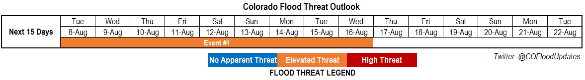
Valid Dates: 8/8-8/21
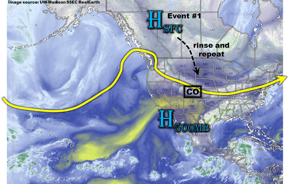
As shown in the water vapor image, below, a “rinse and repeat” type pattern is expected over the next 7+ days for this edition of the 15-day Colorado Flood Threat Outlook. Speaking strictly from the perspective of upper-level flow, this pattern is not all that impressive. With a continuation of a modestly strong jet stream positioned just north of Colorado, this time of year, such a pattern would not strike one as being particularly rainy across out state. The big wildcard, however, is the train of surface high pressure systems that will be coming down out of Canada.
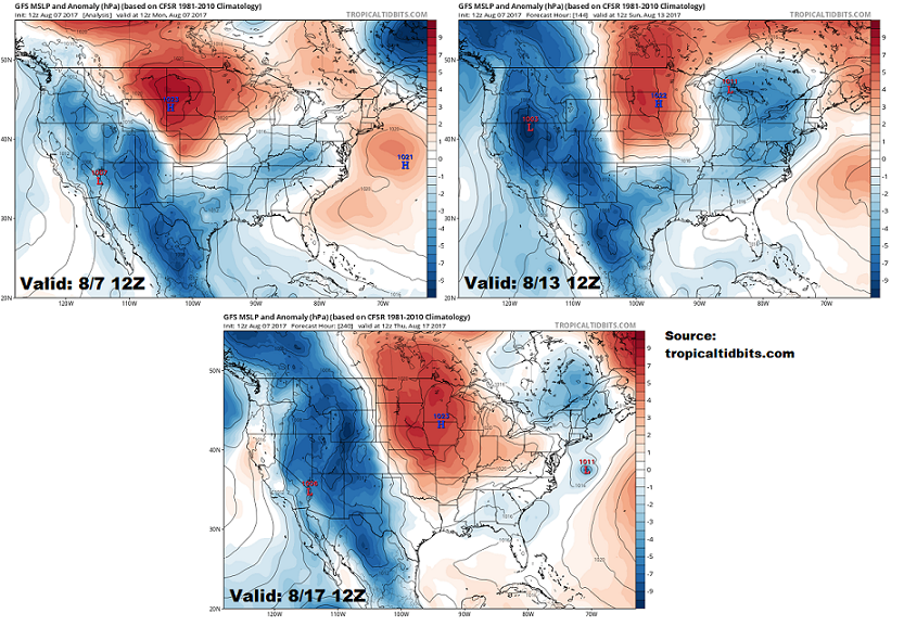
This is well depicted in the forecasted sea-level pressure anomaly maps from the Tropical Tidbits website, shown below. The maps show conditions for this afternoon, this coming Sunday (8/13) and next Thursday (8/17). Note the remarkably similar conditions across Colorado and the northern Great Plains as anomalously strong high pressures are forecasted. The implication of such a pattern for our state is two-fold. First, it promotes southeasterly winds that typically allow for access to above normal moisture levels and in turn, heavy rainfall chances. Second, note the relatively strong surface pressure gradients, which allows for an increased amount of moisture convergence. Stated differently, instead of typical high-elevation storms to be “one and done” in the sense that they quickly decay once they move eastward off the higher terrain, storms persist longer and create outflow boundaries. In turn, this supports larger storm complexes where 3-hour and 6-hour windows of heavy rainfall are possible.
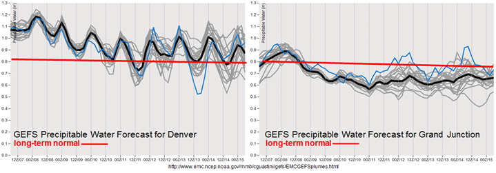
However, the pattern described above only favors above normal precipitation east of the Continental Divide. In short, the moisture provided by the surface high pressures cannot readily make it over the Divide. This is readily shown in the forecasted Precipitable Water (PW) plumes from the GFS ensembles. While Denver stays above normal basically the entire next 8 days, Grand Junction drops below normal and stays there. Thus, while we expect some monsoonal moisture and very isolated heavy rainfall to be possible in the climatologically favored southwest areas, the rest of the western slope will be on the drier side.
We have identified one prolonged precipitation event for this Outlook, which is described in more detail below.
Event #1: Tuesday (8/7) through Wednesday (8/16)
Prolonged Elevated Flood Threat for daily rounds of heavy rainfall east of the Continental Divide; Arkansas River basin will be vulnerable to riverine flooding
With Precipitable Water continuing to stay at or above 1 inch east of the Continental Divide, daily rounds of shower and thunderstorm activity are expected. Storms will form off the higher terrain first but then track eastward for at least several hours, especially over the Palmer and Raton Ridges. Max 1-hour rainfall up to 2.4 inches (east) and 1.9 inches (west) will be possible, supporting isolated flash flooding, small stream flooding and street flooding in urban areas. In addition, max 3-hour rainfall up to 3.1 inches (east) and 2.5 inches (west) will support mud flows and debris slides, especially in regions with saturated soils. In addition, the threat of isolated severe weather (mainly large hail) will exist especially towards the Kansas border.
In addition to the short-term hazards described above, we are now more confident that the Arkansas River and its major tributaries (namely: Monument Creek, Fountain Creek, Purgatoire River, Huerfano River, Apishapa River) will be in a prolonged elevated risk of riverine flooding. Current flows in the Arkansas River basin are above the 75th percentile at many locations and saturated soils will promote very efficient runoff. While at this time we expect that any riverine flooding will be short-duration (i.e. peak during late afternoon and subside during the overnight hours), please stay tuned to daily Flood Threat Bulletins as this could change.