Issue Date: Monday, July 31, 2017
Issue Time: 1:30PM MDT
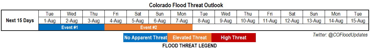
Valid Dates: 8/1 – 8/15
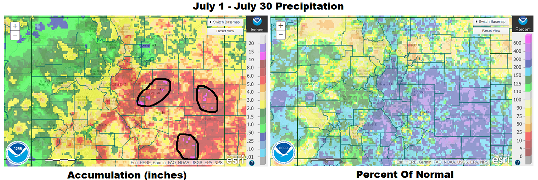
After quiet a memorable stretch of active weather, noticeable drying has begun across roughly the western half of our state. Before getting to today’s Outlook, we want to reflect on just how impressive the recent rainfall has been. Below are 30-day precipitation estimates from the NOAA River Forecast Centers. Isolated parts of southeast Colorado have received over 10 inches (even as high as 15 inches) of rainfall since July 1st. Even more impressively is that this has occurred through a prolonged stretch of days with very heavy rainfall, as opposed to one or two events. So how does this stack up with climatology? Average July precipitation depends strongly on elevation, but east of the Continental Divide, roughly ranges from 1.5 inches in the lowest elevations to as much as 4 inches in the foothills of the Palmer Ridge and Wet Mountains. Thus, over the last 30 days, isolated locations circled in the left map below, have experienced anywhere from 3 to 5 times their normal rainfall. Looking at NOAA Atlas 14 guidance, this equates to a 1 in 100-500 year event, depending on your exact location. For example, in eastern El Paso County, Atlas 14 estimates that a 30-day rainfall of 10.3 inches is a 1 in a 100 year event, with the 1 in the 1000 year event estimate being 13.7 inches.
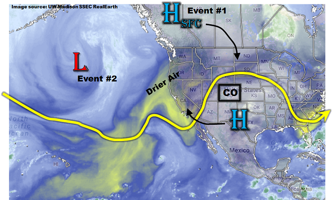
Shifting the focus back to the Outlook, this afternoon’s water vapor image, below, shows some notable changes in the weather pattern across western North America. The upper-level ridge located south of Colorado, which has been responsible for moisture advection into the state, has expanded westward. The upper-level flow is currently switching to a more westerly component, which is now advecting much drier air from the west (see dryness over California). In addition, a strong surface high pressure is expected to move southward out of Canada over the next 72 hours. A cool (or even “cold”?!) frontal passage is expected across eastern Colorado that will limit high temperatures to as much as 15F below normal by mid-week. Frontal dynamics will likely support light to moderate precipitation that we label Event #1, but with limited instability, we currently do not expect a flood threat. Thereafter, a dynamic pattern will ensue with an upper-level trough expected to establish across the central United States. Frequent shortwave and surface frontal passages are expected across eastern Colorado, which should be accompanied by at least 24 hours of return flow to elevate moisture levels. We expect a multi-day elevated flood threat (Event #2) mainly across northeast Colorado. However, with fast steering winds, only isolated heavy rainfall (though with possible severe weather) is currently expected.
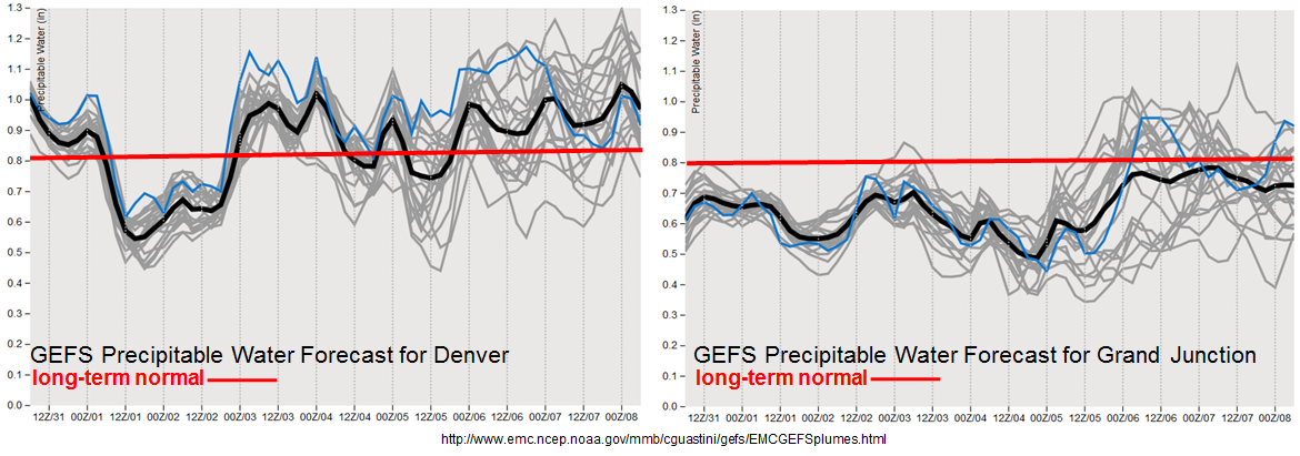
The forecasted Precipitable Water plumes from the GFS Ensembles, below, show that Denver will continue to experience average to above average moisture levels. Meanwhile, Grand Junction will remain mainly below normal. Overall, we expect a pause in the monsoon, and an increase in “action” for northeast Colorado.
We have identified two precipitation events for this Outlook, which are described in more detail below.
Event #1: Tuesday (8/1) through Thursday (8/3)
No Apparent Flood Threat though light to moderate precipitation will be possible
Elevated moisture levels will continue to be scoured out of Colorado as upper-level westerly flow advects in drier air. On Tuesday and Wednesday, scattered thunderstorms will be possible mainly across southern Colorado. However, with faster steering winds, total precipitation is expected to stay on the lighter side, in the 0.5 – 0.75 inch range (hence, no precipitation map). On Thursday, a strong, fall-like cool front will move southward across eastern Colorado, stabilizing the air mass and putting a cap on heavy rainfall coverage and intensity. Some upslope rain showers and perhaps a weak thunderstorm are expected, but flooding is not expected at this time.
Event #2: Friday (8/4) through Monday (8/7)
Elevated Flood Threat for isolated heavy rainfall with current guidance suggesting northeast Colorado as target
Summer-time cool fronts are fleeting and return southeasterly flow will quickly set up by Friday. Precipitable water is expected to return back into the 0.9 – 1.1 inch range (which is above normal). Isolated thunderstorms will return to our forecast then, and increase in coverage and intensity into the weekend as one or more additional weak frontal passages is possible. These fronts will act more of focal points for storms, with little temperature changes. The northeast quadrant of the state is expected to see the highest coverage of thunderstorm activity. At this time, we foresee max 1-hour rain rates up to 1.2 inches (west) and 1.6 inches (east). In addition, severe weather chances, are expected to increase as bulk wind shear ramps up to above 30 kts. We have labeled this event with an elevated flood threat mainly for isolated flash flooding. Stay tuned to the next Outlook for a better assessment of this event.