Issue Date: 8/21/2015
Issue Time: 9:45AM
— NO Flood Threat Today
— Elevated Fire Threat West of the Continental Divide
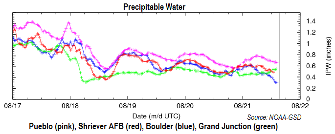
The last several days have been some of the driest days since the start of the Flood Threat Bulletin season. Today, this streak will continue. As the chart shows, below, Precipitable Water (PW) values are in the 0.3 to 0.6 range across the state. These values are expected to stay in this range today, squashing chances of heavy rainfall. Overall, we expect sunny to partly cloudy skies and seasonable temperatures today. The very southeast corner of Colorado, namely Baca and Prowers counties, may see a stray weak thunderstorm this afternoon and early evening. However, the odds for a storm a quiet low, less than 10%. No flooding is expected today.
There is an elevated fire threat today across and west of the Continental Divide. One of the best predictors of wildfire activity is consecutive dry days. And we have seen a string of such days over western Colorado now. A combination of moderate wind speeds, very low relative humidity and decreasing soil moisture will raise the chances of wildfires.
Today’s Flood Threat Map
For more information on today’s flood threat, see the map below (hover over threat areas for more details). For Zone-Specific forecasts, jump below the map.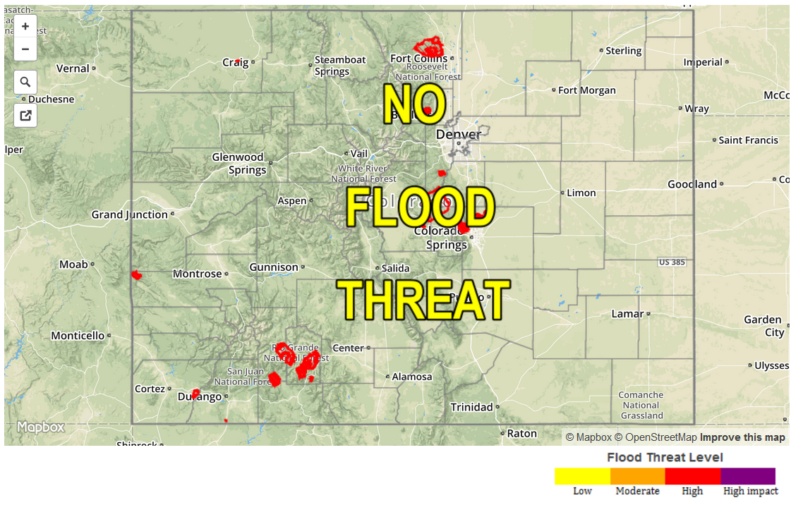
Zone Specific Forecasts
Front Range, Urban Corridor, Northeast Plains, Southeast Plains, Palmer Ridge, Raton Ridge, Southeast Mountains:
Mostly sunny and much warmer today with highs in the 60s in the higher terrain to the mid 90s in the lower elevations of the Arkansas River valley. A stray thunderstorm cannot be ruled out in Baca and Prowers County during the late afternoon and early evening. However, rainfall will be limited to 0.4 inches or less due to fast storm motion. Flooding is not expected today.
Southwest Slope, San Juans, San Luis Valley, Central Mountains, Northern Mountains, Grand Valley, Northwest Slope, Southwest Slope:
Mostly sunny and much warmer today with highs ranging from the mid 60s in the highest terrain to the mid 90s in the lower valleys. Relative humidity values are expected to drop into the 10-20% range today, which will cause an elevated wildfire threat. Moderate wind speeds and decreasing soil moisture will also contribute to the risk. Please check your local National Weather Forecasts for more detailed fire risk information.